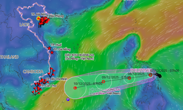
The National Center for Hydro-Meteorological Forecasting (NCHMF) reported that at 1 PM today, a tropical depression was located in the coastal area east of central Philippines. It had maximum sustained winds of force 6, gusting to 8, and was moving west at 5-10 km/h.
The NCHMF forecasts that by 1 PM tomorrow, the tropical depression will remain in central Philippines, maintaining its intensity while changing direction to west-southwest at 10-15 km/h. By 1 PM on 8/12, it is expected to be in the eastern part of the central East Sea, maintaining its strength and direction but increasing its speed to 15-20 km/h.
The Hong Kong Observatory currently believes that the tropical depression will weaken upon reaching the central East Sea and is unlikely to strengthen into a typhoon.
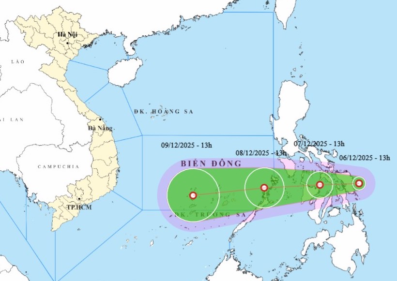 |
Forecast track of the tropical depression. *Photo: NCHMF*
Due to the tropical depression, the eastern part of the central East Sea will experience winds of force 6, gusting to 8, with waves 2-4 meters high, starting in the early morning of 8/12. Vessels in the danger zone may encounter thunderstorms, whirlwinds, strong winds, and high waves.
The NCHMF predicts that in December, the East Sea may see one to two typhoons or tropical depressions. The Central and South Central regions are likely to experience one to two widespread heavy rain events. Rainfall from southern Quang Tri to the northern South Central coast is expected to be higher than the multi-year average, with a continued high risk of flash floods and landslides.
The ENSO phenomenon, a Pacific climate oscillation, is forecast to remain in a La Nina phase – known for increasing rainfall and cold air – until 2/2026, normalizing between 3/2026 and 5/2026.
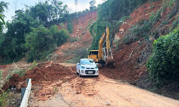
By the end of November, the East Sea had recorded 15 typhoons and tropical depressions, making 2025 the year with the most cyclones since observations began in 1961. Recently, Typhoon Koto, though weakening at sea, still caused heavy rain and landslides in the South Central region.
This year's typhoon season saw many extreme developments, including: Typhoon Wutip appearing in June – the first time in over 40 years; Typhoon Ragasa reaching force 17, gusting above 17, making it the strongest ever in the East Sea; and a tropical depression in late November originating from Typhoon Senyar, which moved from the Indian Ocean to the Northwest Pacific, an unprecedented event.
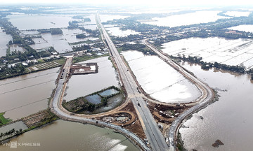
2025 also witnessed widespread severe flooding, with peak flood levels on many rivers exceeding historical marks in the Northern, Central, Central Highlands, and lower Mekong Delta regions. Rarely have exceptionally large floods occurred simultaneously on 20 rivers.
Natural disasters have caused approximately 100 trillion dong in damage and left 409 people dead or missing since the beginning of the year.
Gia Chinh