The National Center for Hydro-Meteorological Forecasting reported that at 7 am today, the tropical depression was located in the central Philippines. It maintained a maximum wind speed of 49 km/h, equivalent to level 6, with gusts up to level 8, and continued its westward movement from yesterday, but its speed increased to 15 km/h.
It is forecast that by 7 am tomorrow, the tropical depression will be in the waters east of Palawan island, Philippines. It is expected to maintain its intensity, moving west-southwest at a speed of 15-20 km/h. The storm tends to shift southward due to interaction with cold air spreading from the north. By 7 am on 9/12, the tropical depression will be located northeast of the Truong Sa special administrative region, about 240 km east-southeast of Song Tu Tay island. It is expected to maintain its intensity and direction, with its speed increasing to 20 km/h. The Hong Kong meteorological station stated that the tropical depression currently has a strength of 45 km/h; it will weaken to 40 km/h upon entering the East Sea and continue to dissipate.
Due to the influence of the tropical depression, starting tomorrow morning, the southeastern waters of the central East Sea (including the northeastern waters of the Truong Sa special administrative region) will experience winds gradually strengthening to level 6, with gusts up to level 8, and sea waves 2-4 m high. Vessels operating in the aforementioned dangerous area are likely to be affected.
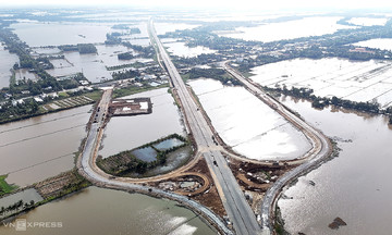
The National Steering Committee for Civil Defense yesterday issued an official dispatch requesting coastal provinces from Quang Tri to An Giang to closely monitor the tropical depression's developments. They are to notify vessels in dangerous areas to proactively avoid the storm and prepare rescue equipment for any potential situations.
The National Center for Hydro-Meteorological Forecasting anticipates that in December, the East Sea could experience one to two storms or tropical depressions. The Central and South Central regions are likely to see one to two widespread heavy rainfall events, with precipitation from southern Quang Tri to the northern South Central coast exceeding the multi-year average. The risk of flash floods and landslides remains high.
The ENSO phenomenon (climatic oscillation over the Pacific Ocean) is forecast to continue leaning towards the La Nina phase (a state that increases rainfall and cold air) until February 2026, before returning to normal from March to May 2026. By the end of November, the East Sea had recorded 15 storms and tropical depressions, making 2025 the year with the most cyclones since observational data began in 1961. Recently, despite weakening at sea, typhoon Koto's circulation still caused heavy rain and landslides in the South Central region. Disasters from the beginning of the year to date have caused damages of about 100 trillion VND, resulting in 419 deaths and disappearances.
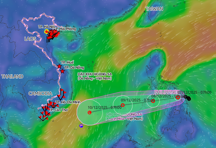 |
Forecast track of the tropical depression. Photo: Disaster Monitoring System.
Gia Chinh