China's Ministry of Emergency Management activated a level IV emergency response for typhoon and flood on 23/8 in preparation for Typhoon Kajiki. The typhoon is currently in the South China Sea and is forecast to bring heavy rain and strong winds to the southern provinces of Guangdong and Hainan.
A level IV alert is the lowest in China's four-tier warning system. The most severe warning is level I (red), followed by orange, yellow, and blue.
 |
Boats return to port in Sanya, Hainan province, China on 23/8 to avoid Typhoon Kajiki. Photo: AFP |
Boats return to port in Sanya, Hainan province, China on 23/8 to avoid Typhoon Kajiki. Photo: AFP
Hainan officials raised the warning level to II yesterday evening. Phoenix International Airport in Sanya, Hainan, announced its closure from 10 a.m. on 24/8.
According to Guangdong's meteorological agency, heavy rain and strong winds are expected to sweep across the Leizhou Peninsula and coastal areas of Maoming, Yangjiang, and Jiangmen cities on 24/8 and 25/8.
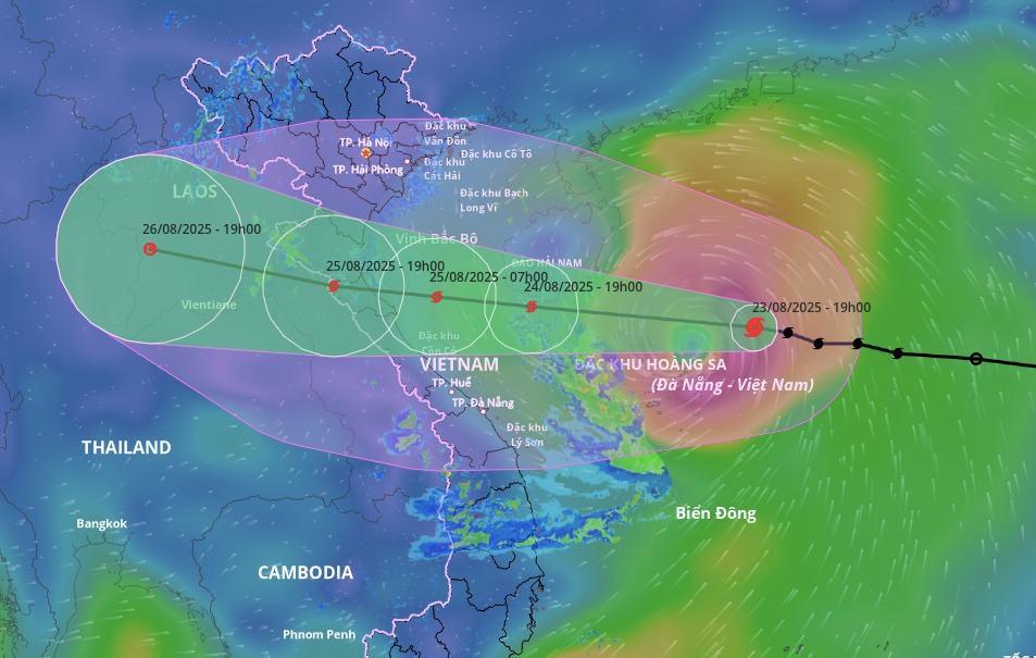
In Vietnam, the National Center for Hydro-Meteorological Forecasting reported that Typhoon Kajiki intensified to a category 11 storm on the evening of 23/8 and is expected to reach category 13 by the evening of 24/8, bringing strong winds and heavy rain to the northern delta and the Thanh Hoa to Hue regions. The typhoon is moving westward at a speed of 20-25 km/h.
Vietnamese meteorological authorities have issued a level 4 disaster risk warning (on a scale of 1 to 5) for the coastal areas from Thanh Hoa to Quang Tri, and for the inland areas from Thanh Hoa to northern Quang Tri. A level 3 warning has been issued for the western North China Sea (including the Paracel Islands), the Gulf of Tonkin, and the sea areas from southern Quang Tri to Hue.
 |
Forecast track and affected area of Typhoon Kajiki, evening of 24/8. Photo: Disaster Monitoring System |
Forecast track and affected area of Typhoon Kajiki, evening of 24/8. Photo: Disaster Monitoring System
By noon on 25/6, the typhoon is expected to make landfall between Thanh Hoa and northern Quang Tri, with winds of category 10-11 and gusts of category 13, before moving further inland into central Laos.
The Japan Meteorological Agency predicts the typhoon will intensify as it approaches land. While near the Paracel Islands, it is expected to have winds of 108 km/h, but it could reach a maximum of 144 km/h upon landfall. The Hong Kong Observatory has made a similar prediction about the intensity and suggests the typhoon's center will hit Nghe An and Ha Tinh provinces in Vietnam.
Nhu Tam (Xinhua, China Daily)