The China Meteorological Administration (CMA) announced on 23/9 that Super Typhoon Ragasa is expected to make landfall between Shenzhen and Xuwen County, Guangdong Province, tomorrow.
The CMA nicknamed Ragasa the "King of Storms" in the Northwest Pacific, stating it poses a greater threat than the four typhoons – Wutip, Wipah, Tapah, and Mitag – that hit Guangdong earlier this year. The agency also warned of torrential rain accompanying the typhoon's landfall.
Hong Kong's Dimsum Daily called Ragasa "King of the Winds," with wind speeds exceeding category 17 on the Beaufort scale.
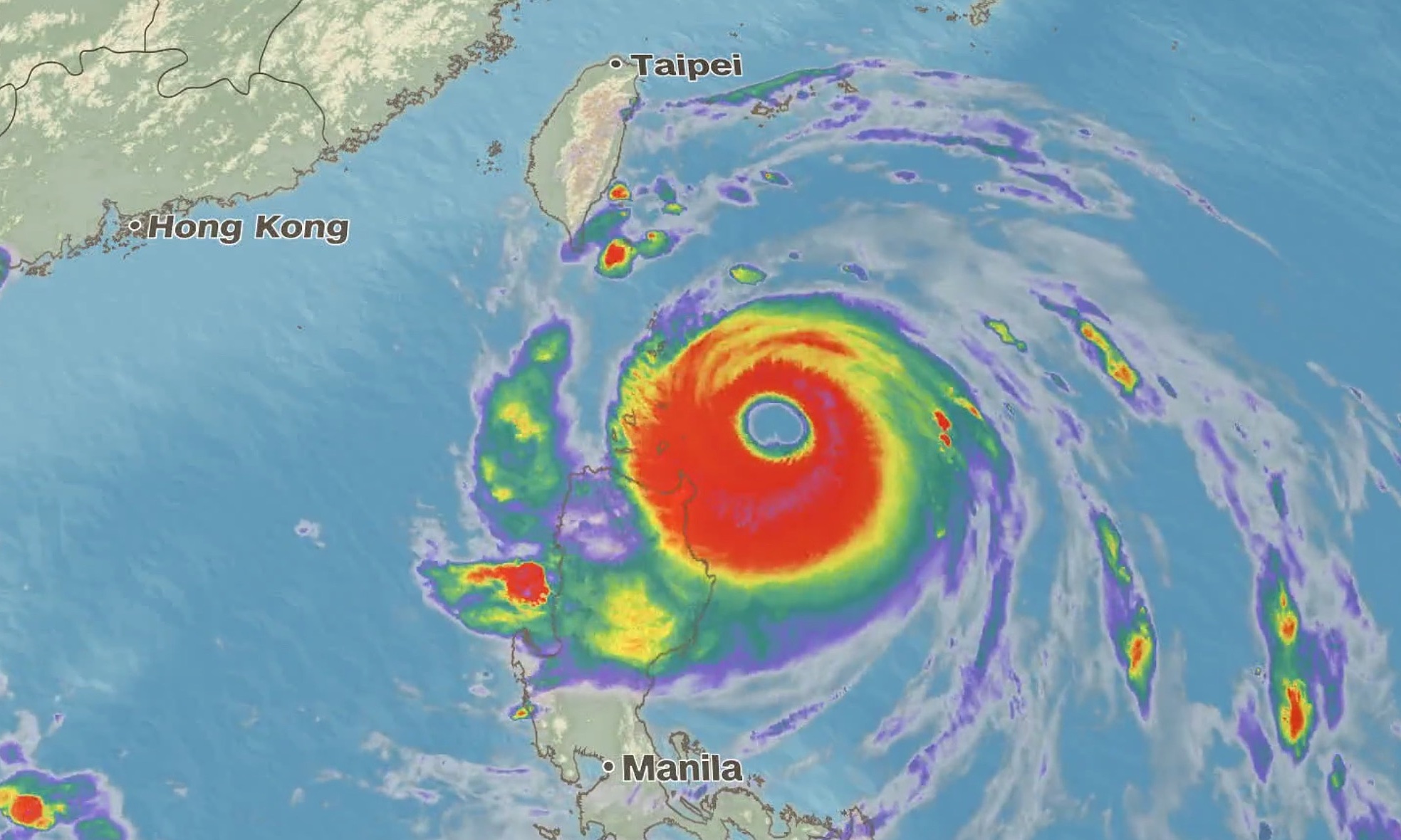 |
Typhoon Ragasa sweeps across the Philippines on 22/9. Graphic: CNN |
Guangdong's Meteorological Bureau forecasts heavy rain and winds of 8-10 on the Beaufort scale starting 23/9 in eastern and southern parts of the province, including the Pearl River Delta, Meizhou, and Heyuan.
Heavy rainfall is expected to continue on 24/9 in eastern, western, and some northern areas of Guangdong. Ragasa is predicted to make landfall once or multiple times as it moves westward.
On 23/9, Chinese authorities ordered school and business closures in at least 10 cities, affecting tens of millions of residents and thousands of factories in the southern industrial hub.
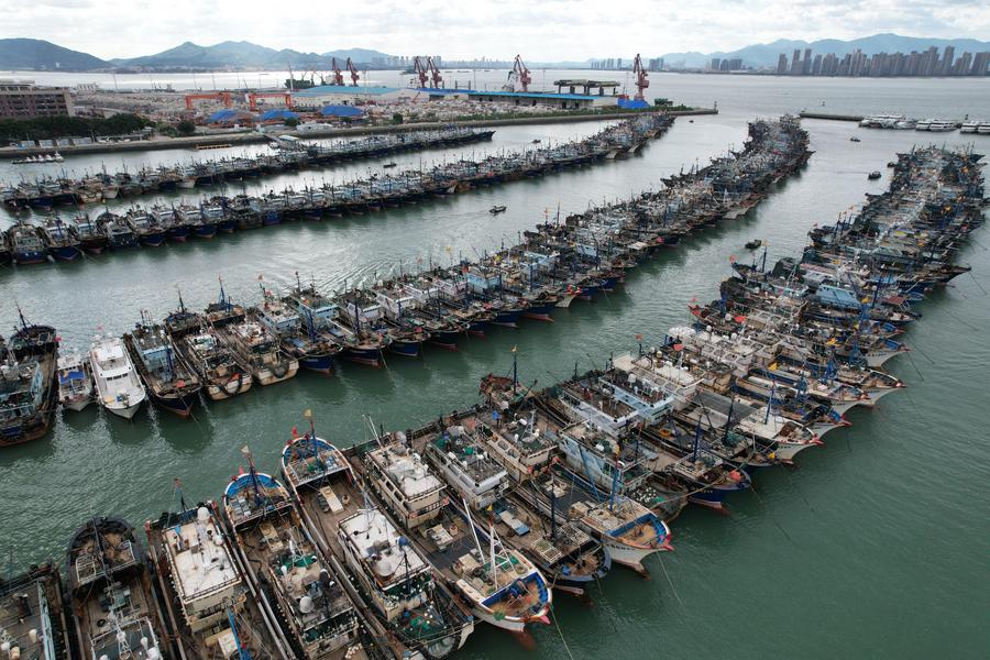 |
Boats anchored at a fishing port in Xiamen, Fujian, southeast China on 22/9. Photo: Xinhua |
Guangdong has issued its highest typhoon alert as Ragasa approaches with gusts of up to 230 km/h, according to the Hong Kong Observatory.
Guangdong's emergency response agency urged local authorities to "resolutely implement preventive measures to ensure the safety of lives and property and minimize damage" caused by the typhoon.
Shenzhen has evacuated 400,000 people and urged residents to stay indoors unless absolutely necessary. Schools, markets, and businesses were closed as of this afternoon. Other major cities like Zhuhai, Dongguan, and Foshan are also on high alert.
Earlier, The Weather Network (TWN), a Canadian meteorological analysis organization, reported that Super Typhoon Ragasa reached sustained winds of 270 km/h when it hit the Babuyan Islands in the northern Philippines on 22/9.
This made Ragasa stronger than two other super typhoons this year, Erin in the North Atlantic in August and Errol in the East Indian Ocean in mid-April, making it the strongest globally since the start of the year.
According to Vietnam’s National Center for Hydro-Meteorological Forecasting, by 4 a.m. on 25/9, Typhoon Ragasa will be over southern Guangzhou province, with maximum sustained winds of level 12 and gusts of 15, moving west-northwest at 20-25 km/h. The typhoon is then expected to rapidly weaken into a tropical depression, and by 4 a.m. on 26/9, it will be over northern Vietnam, with wind speeds reduced to level 6 and gusts of 8.
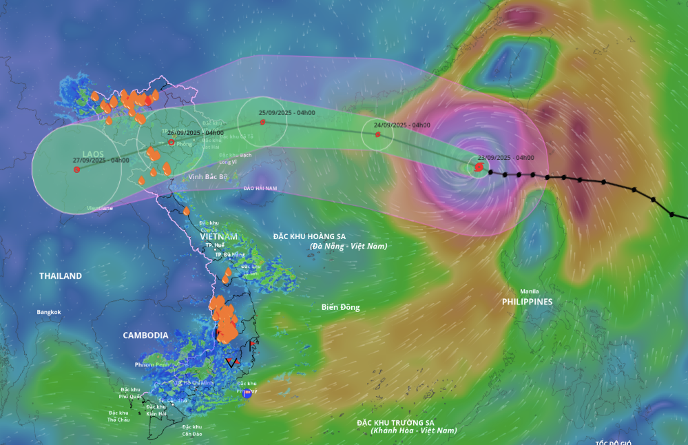 |
Forecast path and area of influence of the super typhoon, morning of 23/9. Photo: Disaster Monitoring System |
Thanh Danh (According to SCMP, Dimsum Daily Hong Kong, AFP)