A severe flash flood on 26/8 in the Nepal border region with China's Tibet buried many structures and caused significant casualties. At least 472 people died, and nearly 1,500 are missing, including hundreds of citizens from countries such as India, USA, Australia, UK, and South Korea.
Satellite images reveal the origin of this devastating event: a 930-meter-long glacier segment near Langtang Lirung peak in the Himalayas collapsed into the valley below. As it fell, the glacier fractured and melted, carrying rocks, sand, snow, and sediment that blocked the Lhende Khola river. Massive ice blocks continued to fall, releasing enough force to breach this natural dam, creating a surging flash flood downstream.
Daniel Shugar, a geologist at the University of Calgary, stated that Planet Labs satellite data showed a 200 square meter ice mass detached at an altitude of about 5,200 meters. It rolled down the mountainside and fell vertically from a height of 1,200 meters into the river below. "The energy from the impact was so powerful that the ice mass disintegrated, sweeping away liquid materials, creating the flash flood", Shugar said.
Hatim Sharif, an engineering professor at the University of Texas at San Antonio, USA, reported on 27/8 that the flood wave, comprising water, crushed ice, and rocks surging through steep mountain valleys, possessed immense destructive power. The powerful flow was laden with mud, sand, gravel, and large boulders, all moving as a fluid mass that Professor Sharif likened to "liquid concrete". He explained that at the same speed, this material impacts a building with approximately twice the force of water, and flood waves can carry car-sized rocks.
Professor Sharif believes that humans cannot outrun this flood. The only way to escape is to move to higher ground, at least 6 meters above. The flood's composition also makes search and rescue operations more dangerous. Sharif stated that the mud and rock sediment layers can retain water for extended periods, making the post-flood terrain "unpredictably altered and perilous". Some areas may be firm enough to support a person's weight, while immediately adjacent, soft mud can trap rescuers waist-deep.
The depth of the mud layer is also an issue. He said that the remaining sediment can be several meters thick, meaning that searching for missing persons "requires manual probing and excavation, making it very slow". Another concern is that new rains could cause this entire mass to continue moving. "Residents in downstream villages need to stay away from riverbanks, even on seemingly calm days", Sharif warned.
A video from Taruka village, over 80 km downstream from the landslide site, captured the surging floodwaters carrying a massive boulder downstream. This demonstrated the flood's immense power and its ability to transport rocks and other debris, increasing its destructive potential.
The International Centre for Integrated Mountain Development (ICIMOD), based in Nepal, reported that a large volume of ice and debris poured into Lhende Khola, a tributary of the Bhote Koshi River. This created a massive flow that carried sediment and large rocks downstream. Water levels in the rivers below rose 7-9 meters within 30 minutes, and many monitoring stations were swept away or damaged.
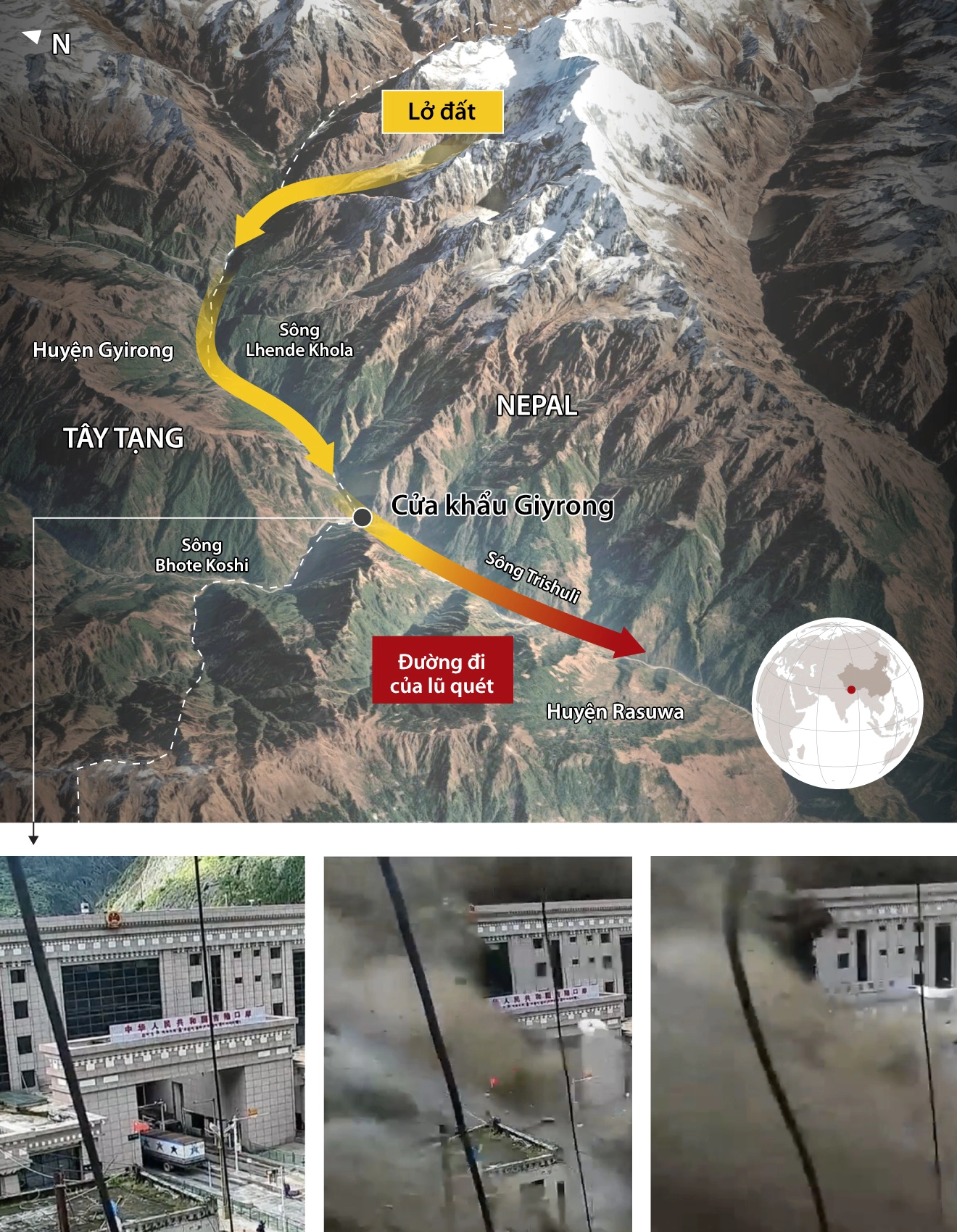 |
Path of the flash flood in Nepal. Graphics: Reuters |
Huyen Le (According to CNN, AFP)