Aman Budathoki, a Nepali helicopter pilot, directly witnessed the devastating power when floodwaters unexpectedly surged down the Bhotekoshi River section in the Himalayas during the flash flood disaster on 26/8.
He initially spotted a massive dust cloud rising from the riverbed and assumed it was a landslide. Moments later, dark, swirling water, laden with earth and rocks, roared down the gorge at an alarming speed. From above, Budathoki estimated the flood waves were 5-6 meters high, powerful enough to toss large vehicles and uproot numerous trees from the riverbanks.
Flash flood sweeps away a bridge in Nepal on 26/8. *Video: RT*
Budathoki described the scene as "terrifying and horrific," a description that seemed understated for the 6-meter walls of water surging through the narrow valley. Pilots like Budathoki regularly fly around Nepal's mountains and are accustomed to harsh weather, but not to disasters of this magnitude.
The United States Geological Survey (USGS) suggested that a glacier collapse triggered seismic activity, leading to cascading effects downstream in Nepal and Tibet.
"This phenomenon was initially believed to be a magnitude 4,4 earthquake. However, additional analysis from nearby seismic stations, long-period seismic waves, and satellite imagery revealed it was actually a glacier collapse and a debris flow, not an earthquake," the USGS stated, adding that the tremor from the landslide registered a magnitude of 5,2.
Saswata Sanyal, an expert at the International Centre for Integrated Mountain Development (ICIMOD), characterized the event as a "cascading hazard sequence." This term describes a hazard, such as an earthquake, triggering an ice and rock avalanche, which then leads to a river blockage and causes a flash flood due to the sudden release of a large volume of water.
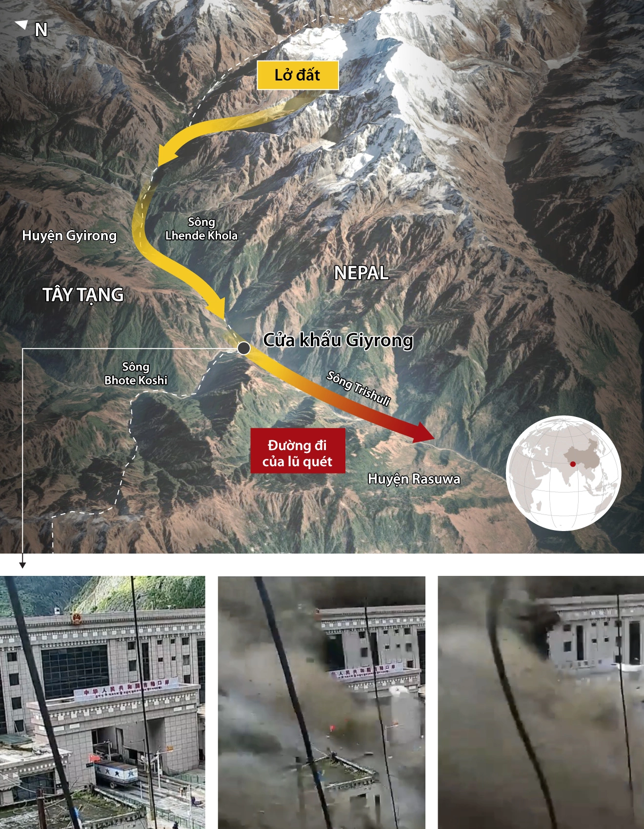 |
Path of the tsunami-like flash flood on the Nepal - Trung Quoc border. *Graphics: Reuters*
Experts emphasize that this sequence of events remains a hypothesis. Research teams are reviewing satellite images, seismic data, and drone footage to determine the exact order of events. Researchers at ICIMOD suggest that multiple simultaneous processes may have contributed to the disaster.
Nepali police recovered 162 bodies, while 468 tourists, mostly foreigners, remain missing. In Trung Quoc territory, the disaster resulted in at least three deaths and 558 missing persons, including 260 foreign nationals.
Nepal is located in the heart of the Hindu Kush Himalaya region, one of the fastest-warming mountainous areas on the planet. Thousands of glaciers and glacial lakes are spread across the country, with many situated high above densely populated valleys.
Nepal's steep terrain makes it particularly hazardous. There is minimal flat land for water to spread, so runoff is always concentrated, swift, and forceful.
ICIMOD research indicates that the rate of ice loss in the Hindu Kush Himalaya region has doubled since 2000, an alarming rate that concerns hydrologists and disaster response specialists. As glaciers shrink and destabilize, debris, meltwater, and ice can combine in dangerous ways, especially during earthquakes.
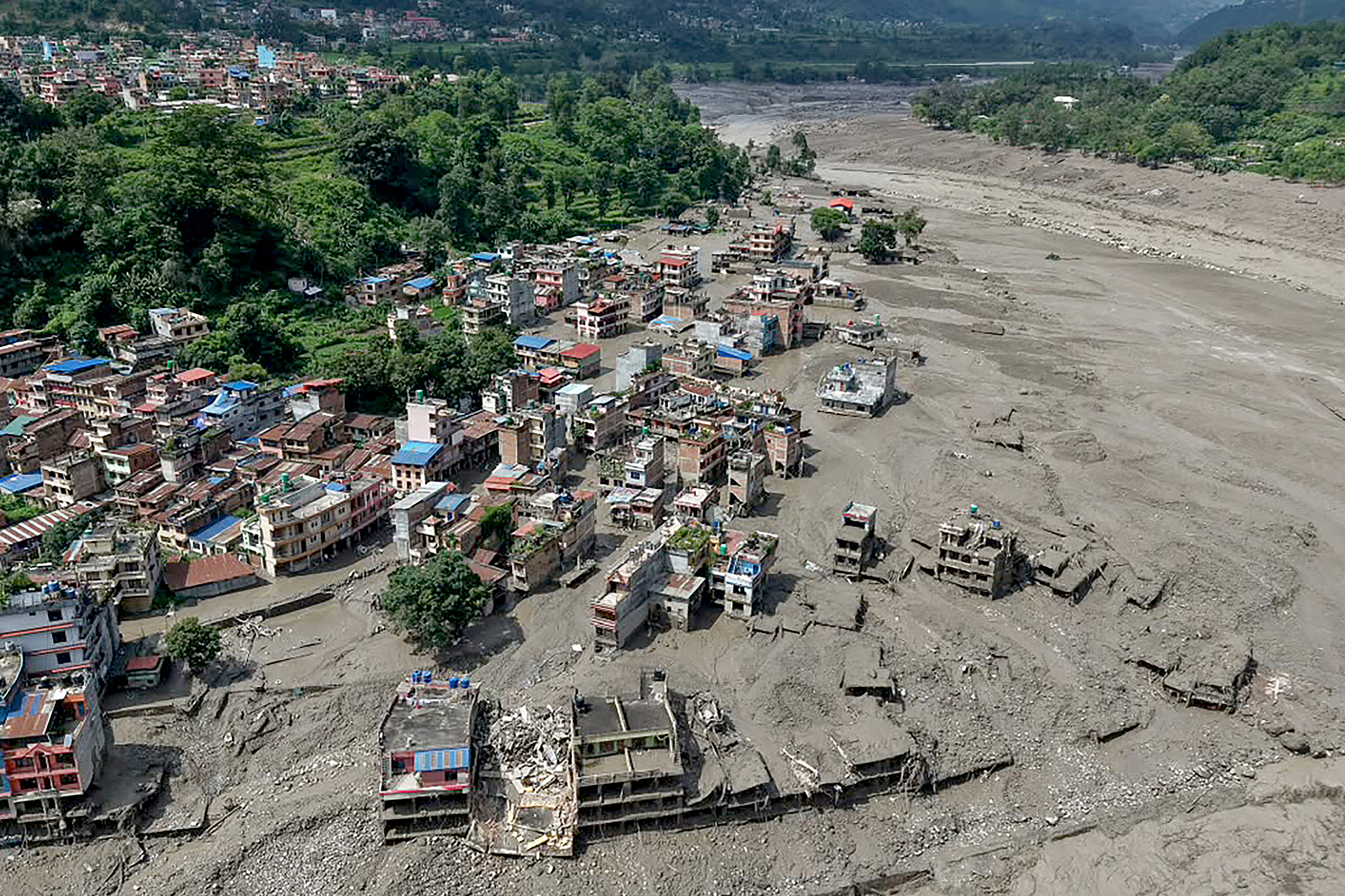 |
Houses partially submerged in muddy river water at Trishuli Bazar, Nuwakot district, Nepal. *AFP*
Scientists stress that this does not mean climate change caused this particular flash flood in Nepal. However, it indicates that underlying conditions are becoming more complex, with more water stored in high-mountain lakes and more unstable slopes situated above communities with minimal resilience.
Huyen Le (According to IB Times, AFP)