This morning, floodwaters from fields and residential areas overflowed national route 1A at Gop intersection (Hong Son commune), submerging a nearly 100-meter stretch by about half a meter. Some household belongings were swept onto the road. Strong currents shifted concrete median barriers, creating hazardous conditions; only high-clearance vehicles could pass. Authorities blocked both ends of the flooded section.
 |
Floodwaters inundate national route 1 through Hong Son commune. Photo: Duy An |
In Song Lu commune, national route 1 near Ong Vat bridge also flooded overnight due to upstream water. By morning, water receded, allowing large vehicles to pass. Authorities assisted residents in low-lying areas with relocating property, children, and the elderly; damages have not yet been assessed.
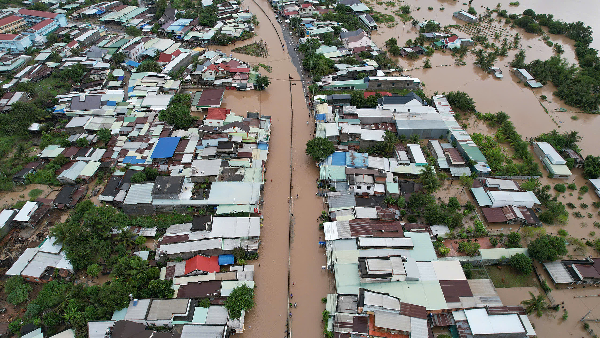
Continuous upstream rain throughout the night caused further flooding in communes of the former Ham Thuan Bac district. Many areas in Tuy Phong, including Lien Huong and Phuoc The, also experienced inundation as water drainage systems struggled to cope.
Several reservoirs in Binh Thuan are regulating flood discharge, with Song Quao reservoir expected to increase its discharge flow to 350-500 m3/s. The Irrigation Works Exploitation Company notified downstream communes to prepare proactively.
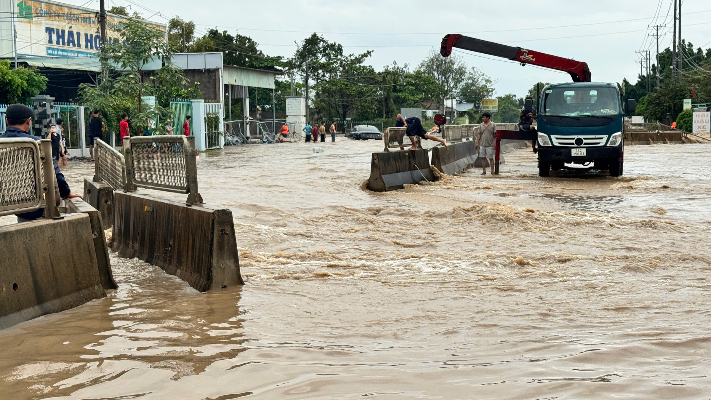 |
Strong currents shifted concrete median barriers on national route 1 through Hong Son commune. Photo: Duy An |
Widespread flooding led authorities to evacuate residents. In Hiep Thanh commune, over 30 km from Da Lat, water rose rapidly from 1h. Authorities continuously warned residents not to enter areas with strong currents and evacuated the elderly and those living alone.
National route 20 through the commune was flooded 0,3-1 meter deep, and many homes were inundated. By this morning, 16 households in low-lying areas were moved to safety; many others relocated themselves to higher ground.
In Khanh Hoa, prolonged rain since last night caused many suburban areas of Nha Trang to flood 30-50 cm deep. Nguyen Luong Bang street was flooded about 30 cm, forcing many to push their vehicles through the low-lying section along the Cai river. Phu Trung area (Tay Nha Trang ward) also experienced localized flooding, with residents using tractors for early movement. Loudspeakers broadcast continuous warnings.
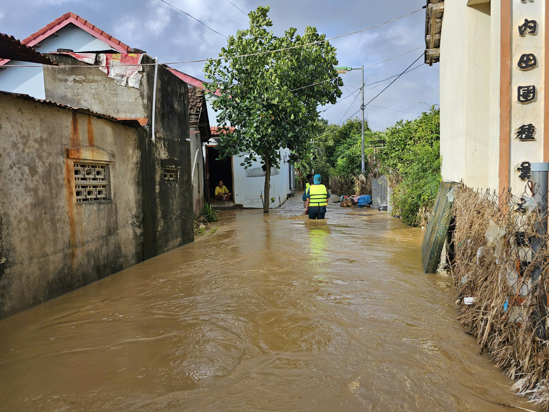 |
Rescue forces call on residents of Bac Nha Trang ward to evacuate. Photo: Trung Ngoc |
Van Binh (Bac Nha Trang ward) stated that water rose rapidly since last night, forcing him and his wife to elevate their belongings as a precaution. "The previous flood caused us to lose many assets; if the water enters today, our family will have to rent temporary accommodation again," he said.
Guard forces were deployed on several roads, prohibiting vehicles from entering flooded areas. By 9h, the water showed signs of slowing its rise.
According to the National Center for Hydro-Meteorological Forecasting, influenced by a tropical depression weakened from storm Koto, from the night of 3/12 to the morning of 4/12, areas from southern Quang Tri to Da Nang, eastern Quang Ngai extending to Dak Lak, Khanh Hoa, and Lam Dong experienced moderate to heavy rain, with some areas seeing very heavy rain accompanied by thunderstorms. Many stations recorded rainfall exceeding 180 mm, including: Ba Na (Da Nang) with 228,2 mm; Phan Dung (Lam Dong) with 202,4 mm; Khanh Hiep (Khanh Hoa) with 196 mm; and Tra Nham (Quang Ngai) with 189 mm.
Over the next 24-48 hours, areas from southern Quang Tri to Da Nang and eastern Quang Ngai will continue to experience moderate to heavy rain, with common amounts of 40-80 mm and localized areas exceeding 120 mm. There is a risk of intense heavy rain exceeding 100 mm within three hours.
Additionally, eastern Gia Lai, Dak Lak, Lam Dong, Khanh Hoa, and the southeastern provinces will receive 20-40 mm of rain, with some areas exceeding 80 mm. The Central Highlands and the Mekong Delta will experience scattered showers and thunderstorms of 10-30 mm, with localized amounts over 60 mm.
Reporting Team