The project starts at the Cha Va intersection (Vinh Long), connecting to the My Thuan - Can Tho expressway, and ends at the IC2 intersection (Can Tho), intersecting with the National Highway 91 - Nam Song Hau connector. This is also the starting point of the Can Tho - Hau Giang - Ca Mau expressway.
The total length of the project is about 17 km, including over 11 km of ramps and access roads in Vinh Long, about 4 km of ramps and elevated roads in Can Tho, and a main bridge spanning the Hau river, approximately 1 km long. The main cable-stayed bridge will have a 300 m navigation clearance, and the access roads will be designed to expressway standards.
My Thuan project management board proposed two options. The first involves building separate expressway and railway bridges, with a preliminary total investment of 24,265 billion VND. The second involves a combined road and rail bridge, with an estimated investment of 28,455 billion VND.
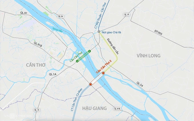 |
Can Tho 2 bridge route. Graphics: Dang Hieu |
The combined bridge option is being considered as the Ministry of Construction is conducting a pre-feasibility study for the TP HCM - Can Tho railway project. This 174 km, 1,435 mm gauge railway is expected to be completed before 2030 to synchronize with the North-South high-speed railway.
The My Thuan project management board recommends using state budget funding for the project, with construction expected to begin in 2026 and be substantially completed by 2030. Upon completion, the Can Tho 2 bridge will connect the My Thuan - Can Tho and Can Tho - Ca Mau expressways, completing the Mekong Delta's transportation network. This will reduce traffic on National Highway 1, improve road safety, and boost socio-economic development in the Southwest region.
Anh Duy