

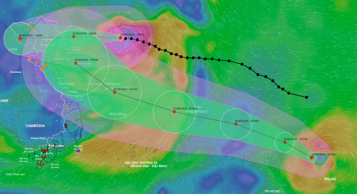
The National Center for Hydro-Meteorological Forecasting reported that at 7 a.m. today, Typhoon Bualoi was located off the Philippines, with maximum sustained winds of 88 km/h, a category 9 storm, and gusts reaching category 11. It is moving west-northwest at approximately 15 km/h.
By 7 a.m. tomorrow, the typhoon's center is expected to remain off the Philippines coast, with winds intensifying to category 9-10 and gusts up to category 12. It will continue its west-northwest trajectory, slowing down to 10-15 km/h. By 7 a.m. on 26/9, the storm is predicted to reach the central Philippines, strengthening to category 10 with gusts of category 12 and accelerating to 20-25 km/h.
 |
Images of the two storms potentially affecting Vietnam. Photo: Disaster Monitoring System |
Images of the two storms potentially affecting Vietnam. Photo: Disaster Monitoring System
Bualoi is forecasted to enter the South China Sea on the night of 26/9, becoming the 10th typhoon in the area this year. By around 28/9, it is expected to reach Vietnam’s Paracel Islands, intensifying to a category 12 storm.
The Japan Meteorological Agency predicts that upon reaching the central South China Sea, Bualoi will veer north towards Hainan Island (China), with maximum sustained winds potentially reaching 126 km/h. The Hong Kong Observatory offers a similar trajectory prediction, anticipating landfall in northern central Vietnam with winds of 120 km/h.
Due to Bualoi's influence, starting the evening of 26/9, the northeastern and central South China Sea will experience increasing winds from category 6 to 11, with gusts up to category 14 and waves reaching 5-7 meters high.
As Bualoi is still far from Vietnam, the meteorological agency has not yet assessed its potential impact. Northern and north-central provinces are currently bracing for a different storm, Typhoon Ragasa, which is heading towards the Leizhou Peninsula (China). Ragasa is projected to reach Quang Ninh - Hai Phong around noon tomorrow with winds of category 8-9.
Gia Chinh


