

Hanoi experienced continuous heavy rain from the night of 25/8 to the morning of 26/8. By 7 a.m. on 26/8, the Hanoi Drainage Company reported over 80 flooded locations, mainly in the inner city, with some areas on Duong Dinh Nghe street submerged under one meter of water.
By the evening of 26/8, 26 locations remained flooded, including Vo Chi Cong (UDIC building), Lac Long Quan, Le Duc Tho (My Dinh square), Duong Dinh Nghe, Phan Van Truong, Tran Binh, Hoa Bang, Phuc Xa, Pham Hung, Thien Hien, Nguyen Chinh, Road 2.5 Den Lu (near Den Lu lake), Huynh Thuc Khang, Thai Ha, Nguyen Van Troi, Ngoc Lam, Co Linh, Dam Quang Trung, Thang Long Boulevard underpass, Cau Buou, Yen Xa, Trieu Khuc, Yen Nghia, and Quyet Thang.
The Hanoi Drainage Company attributed the widespread and prolonged flooding to the intense rainfall over a short period. Statistics reveal that in the 24 hours from noon on 25/8 to noon on 26/8, nearly 30 communes and wards received 200-300 mm of rain. Five wards received over 310 mm: Hai Ba Trung (460 mm), Yen So (368 mm), Tay Mo (352 mm), Yen Nghia (334 mm), and O Cho Dua (323 mm).
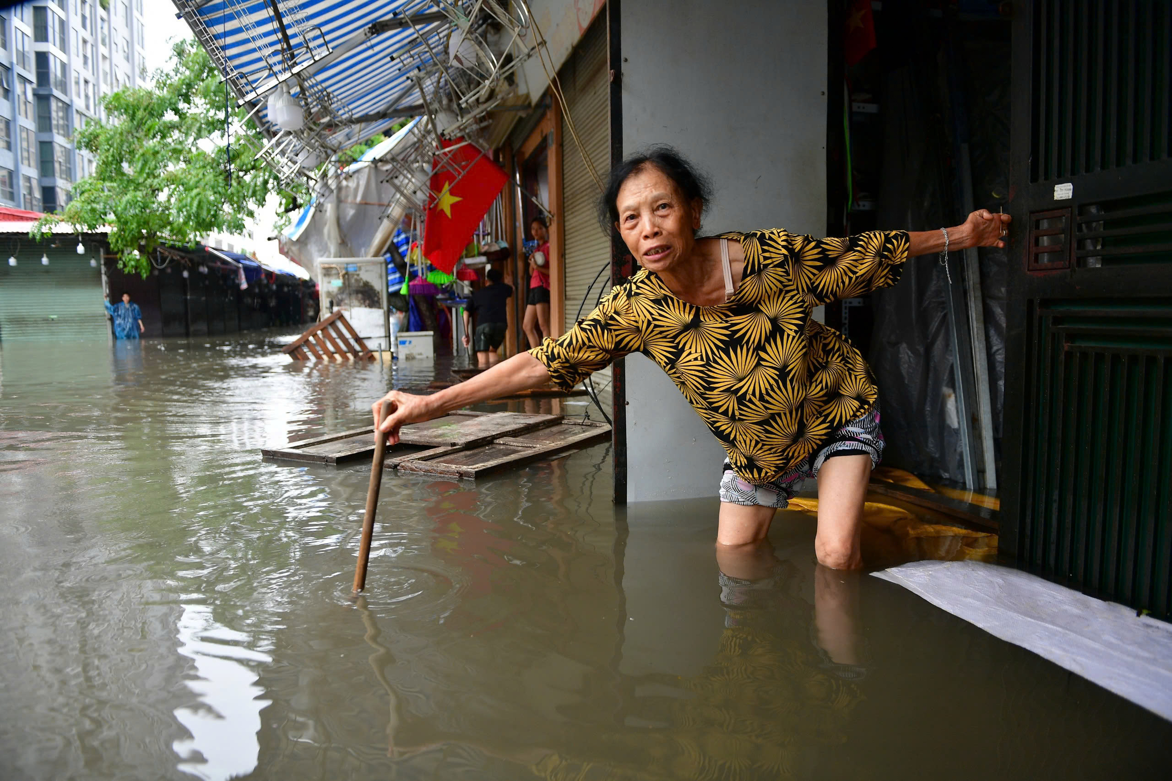 |
Flooding exceeding one meter in the Nha Xanh market area, Phan Van Truong street. Photo: Thanh Tung |
Flooding exceeding one meter in the Nha Xanh market area, Phan Van Truong street. Photo: Thanh Tung
According to Nguyen Van Huong, Head of Weather Forecasting at the National Center for Hydro-Meteorological Forecasting, Hanoi's heavy rainfall resulted from the combined impact of several weather systems. In addition to the remnants of Typhoon Kajiki, Hanoi was situated north of the intertropical convergence zone passing through north-central Vietnam. Simultaneously, a subtropical high-pressure ridge with a moist easterly wind belt encroached upon northern Vietnam.
"Under the combined influence of the intertropical convergence zone and the strong easterly winds of the subtropical high-pressure ridge operating at altitudes of 1,500-5,000 m, the northern delta and midland regions, including Hanoi, experienced heavy rainfall," Huong explained.
Hanoi's drainage infrastructure is another factor contributing to the persistent flooding. According to the Hanoi Drainage Company, the only area with a relatively complete drainage system is the four old core districts: Hoan Kiem, Ba Dinh, Dong Da, and Hai Ba Trung, belonging to the To Lich river basin (77.5 km2). However, this system can only handle 310 mm of rain over two days. With rainfall double the design capacity, as seen recently, the drainage system becomes overloaded, resulting in deep and prolonged flooding.
In the old quarter within the four core districts, the drainage system, built between 1954 and the present, is outdated. Rapid urbanization has altered ground levels, causing localized depressions. In some places, the drainage pipes show signs of deterioration and sagging, leading to flooding on streets like Tong Dan, Dinh Tien Hoang, Phung Hung, Hang Bai - Hai Ba Trung, Lien Tri - Nguyen Gia Thieu, and Phan Boi Chau - Ly Thuong Kiet.
Furthermore, the old quarter has a high concentration of restaurants and businesses that frequently discharge grease and oil into the drainage system, causing blockages. The city has yet to implement regulations encouraging the installation of grease traps in these establishments.
 |
Flooding reaches chest height at the Ecohome 3 apartment complex. Photo: Viet Tuan |
Flooding reaches chest height at the Ecohome 3 apartment complex. Photo: Viet Tuan
Other basins have poor drainage capacity due to a lack of comprehensive investment. Specifically, the Nhue River basin, encompassing the older districts of Cau Giay, Thanh Xuan, Hoang Mai, Nam Tu Liem, Bac Tu Liem, Ha Dong, part of Tay Ho district, and Thanh Tri district, has undergone rapid urbanization. However, its drainage system remains incomplete, lacking sufficient regulation reservoirs, and its main pumping stations are below planned capacity. Rainwater drainage relies primarily on gravity and the water level of the Nhue River.
The Long Bien basin (62 km2) is also experiencing rapid urbanization. While its technical infrastructure follows planning guidelines, directing water flow towards main pumping stations for forced discharge into the Red and Duong rivers, these stations have not yet been constructed. Drainage relies on gravity and the water level of the Cau Bay - Bac Hung Hai river system.
During the recent rainfall, high water levels in the To Lich, Nhue, and Cau Bay - Bac Hung Hai rivers hindered drainage.
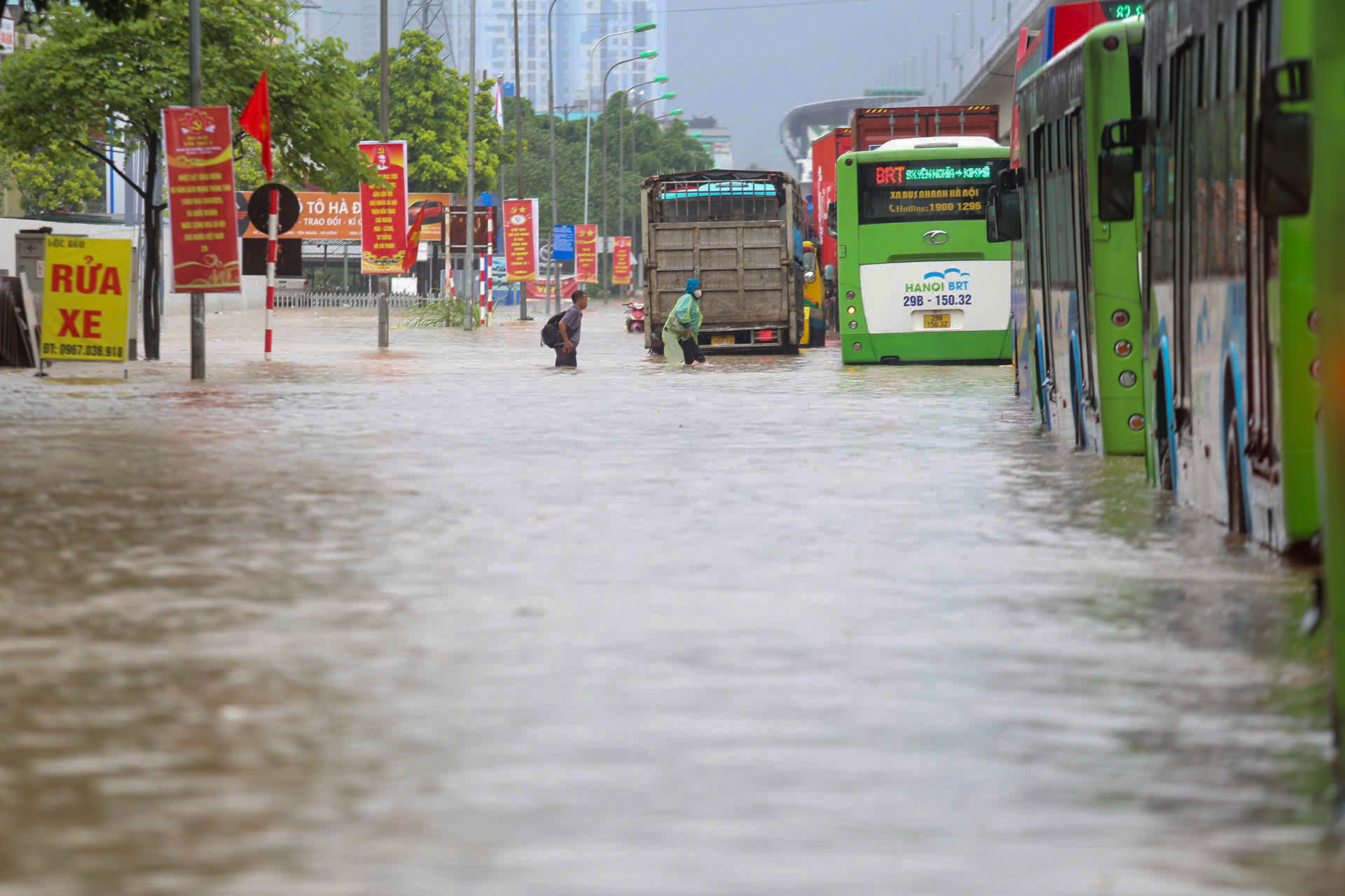 |
Flooding on National Highway 6 in front of Yen Nghia bus station. Photo: Gia Chinh |
Flooding on National Highway 6 in front of Yen Nghia bus station. Photo: Gia Chinh
The western and southwestern areas of Hanoi are also urbanizing rapidly, but their planned technical infrastructure lacks synchronized investment. Urban areas like My Dinh, Nhan Chinh, and Cau Giay, built on former agricultural land with low ground elevation, suffer from reduced natural absorption due to concrete surfaces and inadequate drainage systems, leading to widespread flooding. As of 9 p.m. last night, the roads around the Cau Giay ward headquarters remained submerged under 30-40 cm of water.
The Hanoi Drainage Company also notes that the main pumping stations and large regulating reservoirs in the western and southwestern areas of Hanoi have not reached their planned capacity. Some canals designated for urban drainage are not under the company's management, and drainage relies entirely on gravity, influenced by the Nhue River's water level.
In other areas, the drainage systems along provincial and national roads are built to traffic standards, with rainwater flowing naturally into surrounding fields and ponds. Due to the low density of drainage pipes but the abundance of open land and water bodies, these areas experience less flooding. Flooding, when it occurs, is mainly concentrated in areas with high urbanization rates and underdeveloped infrastructure, such as sections of the Thang Long Highway, National Highway 32, and Road 2B.
Besides heavy rain and inadequate infrastructure, other contributing factors include the reduced surface water area and greenery in Hanoi compared to 10-20 years ago. Public awareness also plays a role, with littering and blockage of drains to prevent odors further impeding water flow and exacerbating the flooding.
Vo Hai - Gia Chinh


