

The Hon Khoai island cluster, part of Dat Mui commune, formerly Ngoc Hien district, comprises five islands: Hon Khoai, Hon Sao, Hon Go, Hon Doi Moi, and Hon Da Le. The islands are situated approximately 11 nautical miles (nearly 20 km) from Rach Tau estuary and 10-12 nautical miles south of the international shipping lane. Hon Da Le, designated as point A2 on the baseline, has a sovereignty marker.
Hon Khoai, the largest island, features a rocky terrain, covers 4 km2, and rises 318 m above sea level. The island boasts abundant fresh water, a diverse ecosystem, a road network of approximately 14 km, and surrounding waters exceeding 1,200 km2. Currently, four units are stationed on the island: the Hon Khoai Border Guard Station, the Navy's 595 Radar Station of Region 5, the Forest Protection Department, and the Lighthouse Station. The island has no civilian population.
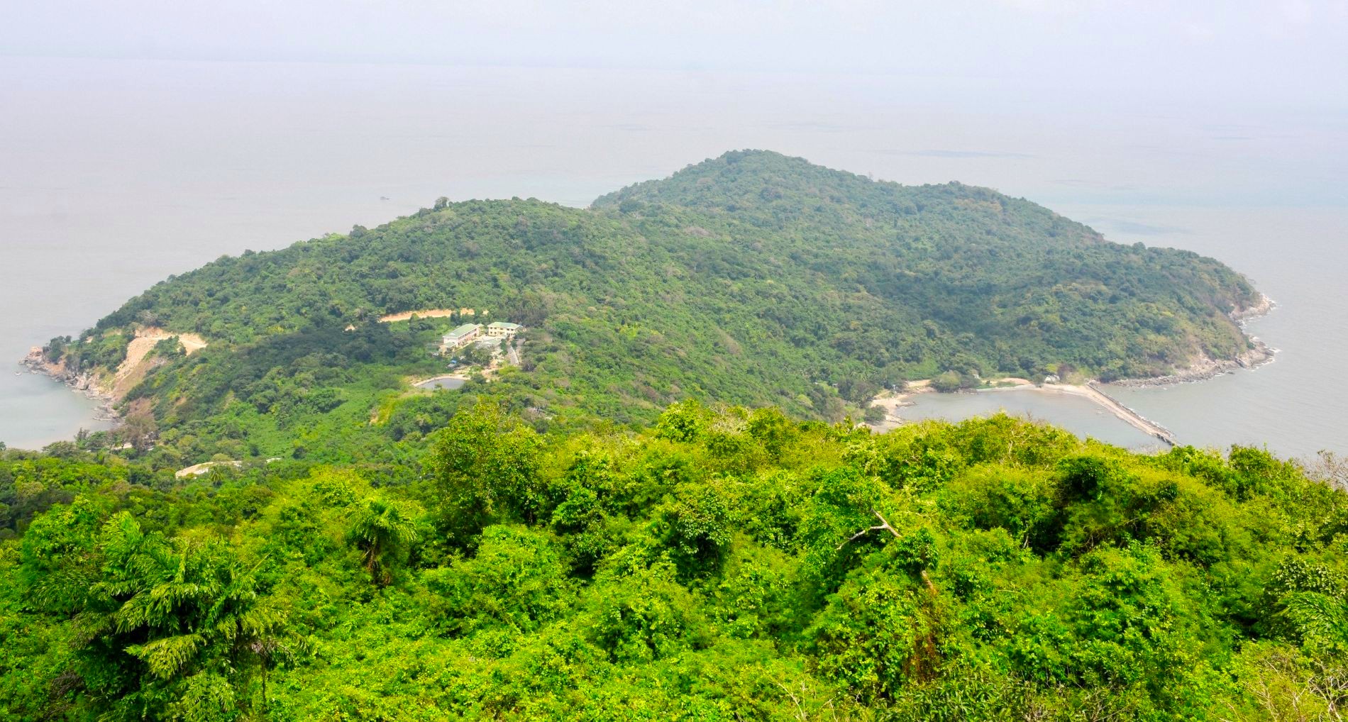 |
Hon Khoai is a strategic island cluster in the southwest sea. Photo: An Minh |
Hon Khoai is a strategic island cluster in the southwest sea. Photo: An Minh
Locals named the island Hon Khoai (Sweet Potato Island) due to its resemblance to a sweet potato. It is also known as Hon Doc Lap (Independence Island) and Giang Tien Island. During French colonial rule, it was called Poulop.
Hon Khoai holds a strategic position in national defense and security, serving as a forward post guarding the airspace, waters, and territorial sea in the southwest. South of the island lies an international shipping lane with constant vessel traffic, transporting goods regionally and globally.
To harness its potential, several key projects are underway to connect infrastructure and develop the marine economy. Upon completion, the North-South Expressway will extend to Dat Mui, connecting with the 82 km Ca Mau-Dat Mui Expressway.
 |
The oversea bridge connecting the mainland to Hon Khoai, approximately 18 km long, will be the longest oversea bridge in Vietnam. Photo: Ministry of National Defense |
The oversea bridge connecting the mainland to Hon Khoai, approximately 18 km long, will be the longest oversea bridge in Vietnam. Photo: Ministry of National Defense
Recently, the Ministry of National Defense commenced three major projects: the Ca Mau-Dat Mui Expressway, the transportation route from Ca Mau Cape to Hon Khoai Island, and the Hon Khoai dual-use general port. These projects will connect the island cluster to the mainland, serving both economic development and national defense.
The route to Hon Khoai Island is designed as an oversea bridge, approximately 18 km long—projected to be the longest in Vietnam. The bridge will be 16.5 m wide, with 4 lanes, a design speed of 80 km/h, and the capacity to transport containers. Constructed by Military Corps 12, with a total investment of over 25,700 billion VND, the project is expected to be completed by the end of 2028.
The route begins at the end of the Ca Mau-Dat Mui Expressway and terminates on the eastern shore of Hon Khoai.
The Hon Khoai Port, under construction in Dat Mui commune, is 17 km offshore. It includes a 1,000 m long wharf with a capacity of 20 million tons of cargo annually. The waterway and turning basin span 203 ha, capable of accommodating vessels up to 250,000 DWT. The project also includes breakwaters, revetments, and technical infrastructure for both civilian and military operations.
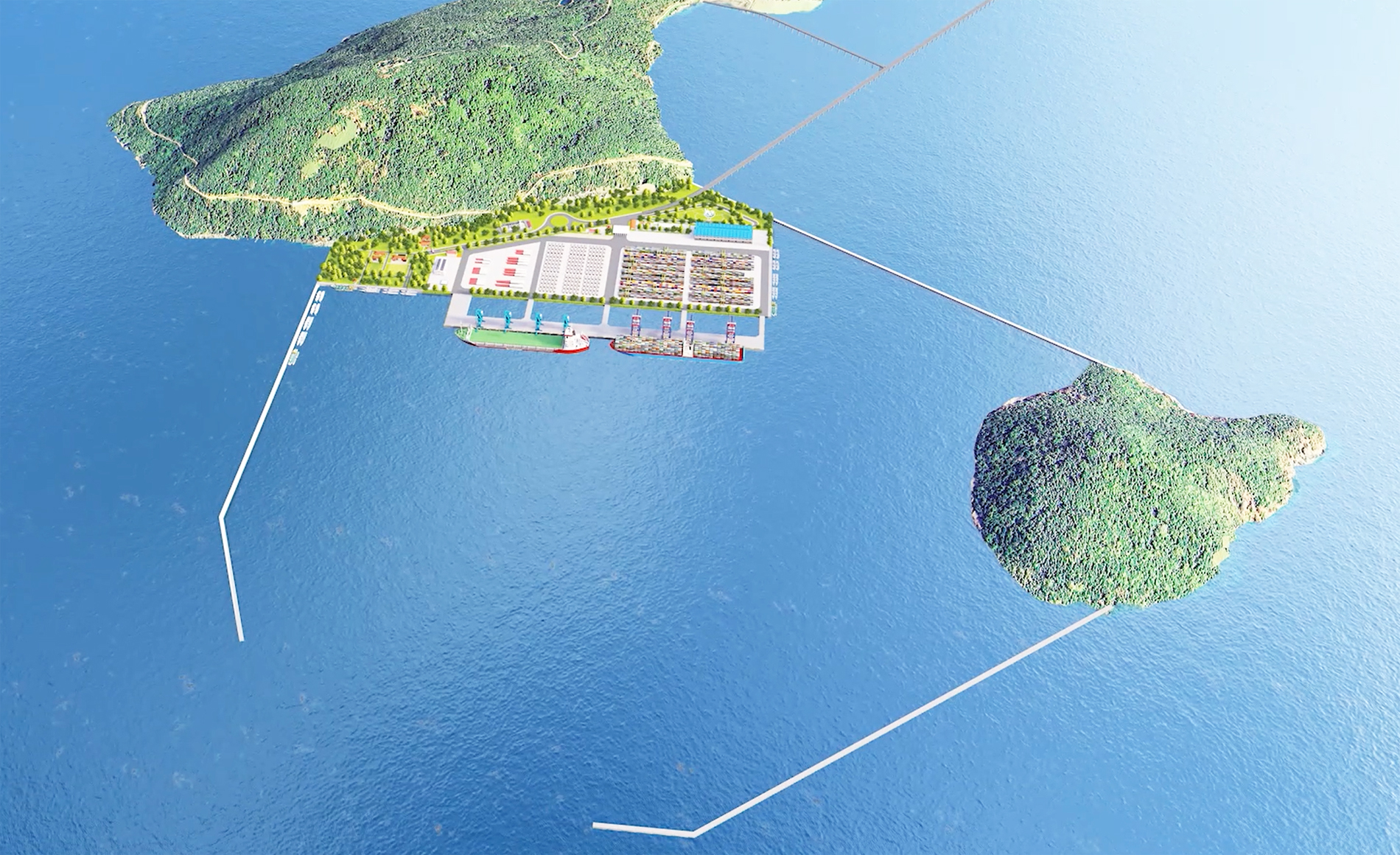 |
Hon Khoai dual-use general port is located approximately 17 km offshore. Photo: Ministry of National Defense |
Hon Khoai dual-use general port is located approximately 17 km offshore. Photo: Ministry of National Defense
Upon completion, the port will expand to 686 ha, with two additional 1,000 m general wharves for 250,000 DWT container ships and two wharves for liquid and gas cargo, accommodating vessels up to 150,000 DWT.
The expressway and port system, once finished, will create seamless connectivity from north to south and from the mainland to the islands, boosting socio-economic development in the Mekong Delta and ensuring national defense in the southwest sea.
Pham Thanh Ngai, Chairman of the Ca Mau Provincial People's Committee, stated that Ca Mau is the only province bordered by the sea on three sides, located in the heart of Southeast Asia, with numerous advantages for marine economic development.
"The Hon Khoai island cluster occupies a strategic location adjacent to the international shipping lane. The surrounding waters have significant natural depth, making it ideal for developing a deep-water port," he said.
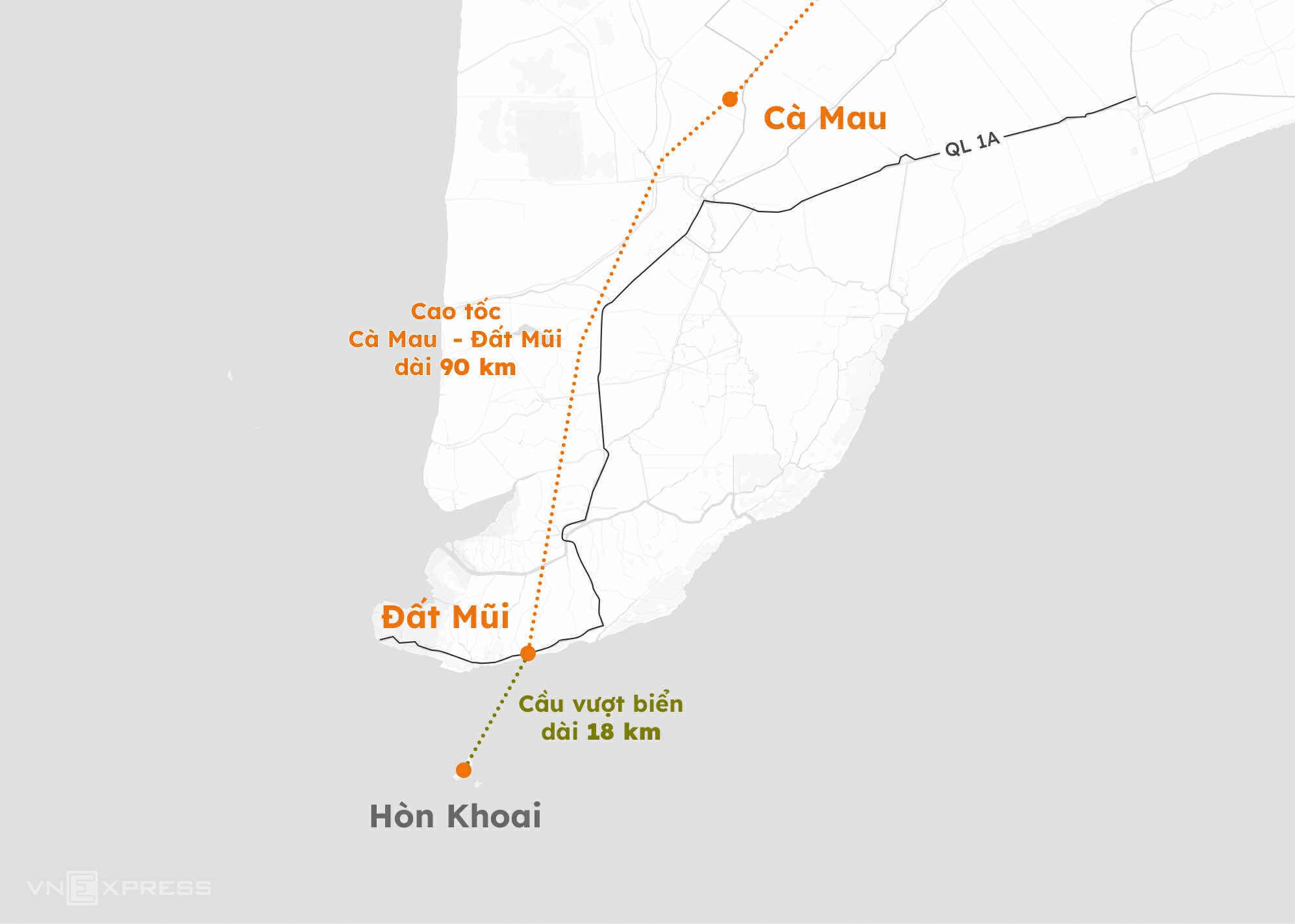 |
Distance from Hon Khoai to the mainland. Graphics: Hoang Thanh |
Distance from Hon Khoai to the mainland. Graphics: Hoang Thanh
Chuc Ly


