

On 25/8, the Gia Lai Department of Culture, Sports, and Tourism collaborated with the Southern Institute of Social Sciences to hold a scientific conference researching the value and preservation direction of the Truong Luy historical site.
Truong Luy is a defensive system built by the Nguyen lords from the 16th century, expanded and completed under the Nguyen dynasty in the early 19th century. The structure stretches about 127 km, through Quang Ngai, (old) Binh Dinh, and Gia Lai, consisting of earthen ramparts, forts, ancient roads, and defensive moats. The entire line is likened to a "central great wall."
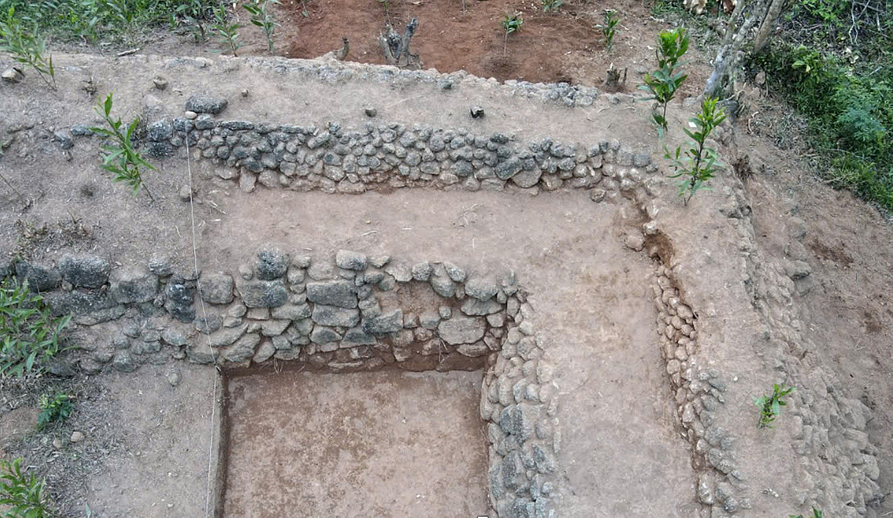 |
Truong Luy at An Quang fort being excavated. Photo: Ngoc Oanh |
Truong Luy at An Quang fort being excavated. Photo: Ngoc Oanh
The section passing through Gia Lai is 14.4 km long, starting from Hoai Son commune (former Hoai Nhon town) to the bordering area of Pho Cuong commune (former Duc Pho district, Quang Ngai). According to historical records, there were nearly 20 guard stations here, including four large ones, typically Don Thu (Don Doi) in La Vuong village, Hoai Son commune.
In June 2025, the Gia Lai Provincial Museum collaborated with the Southern Institute of Social Sciences to excavate three rampart forts: Dong Ham, H4, and An Quang, covering an area of 200 m2. The forts were built at altitudes of 400-800 m, clinging to rocky mountainsides and narrow valleys – advantageous defensive terrain. Fort H4 has a near-square layout, each side 40-50 m long, with rampart walls covered in bushes and thorny bamboo. Few artifacts were found, mainly household ceramics such as pots, bowls, and plates used by the garrisoned soldiers.
The survey results show diverse construction techniques: some sections are entirely made of stone, others have earth embankments inside and stone cladding outside; some forts still have traces of entrances and watchtowers at the corners. According to researchers, this demonstrates creativity and high adaptability to the mountainous terrain. Some suggest that the H’re people may have participated, incorporating their traditional stone stacking techniques.
Regarding the date of construction, many documents record that Truong Luy was built in 1819 under the reign of Gia Long, commanded by General Le Van Duyet. However, some researchers believe that the section through Gia Lai was actually built later, in 1876, when King Tu Duc approved the proposal of Binh-Phu Governor Pham Y to deal with instability, and merged the Binh Dinh rampart with the Quang Ngai rampart to form the "Ngai-Dinh" line.
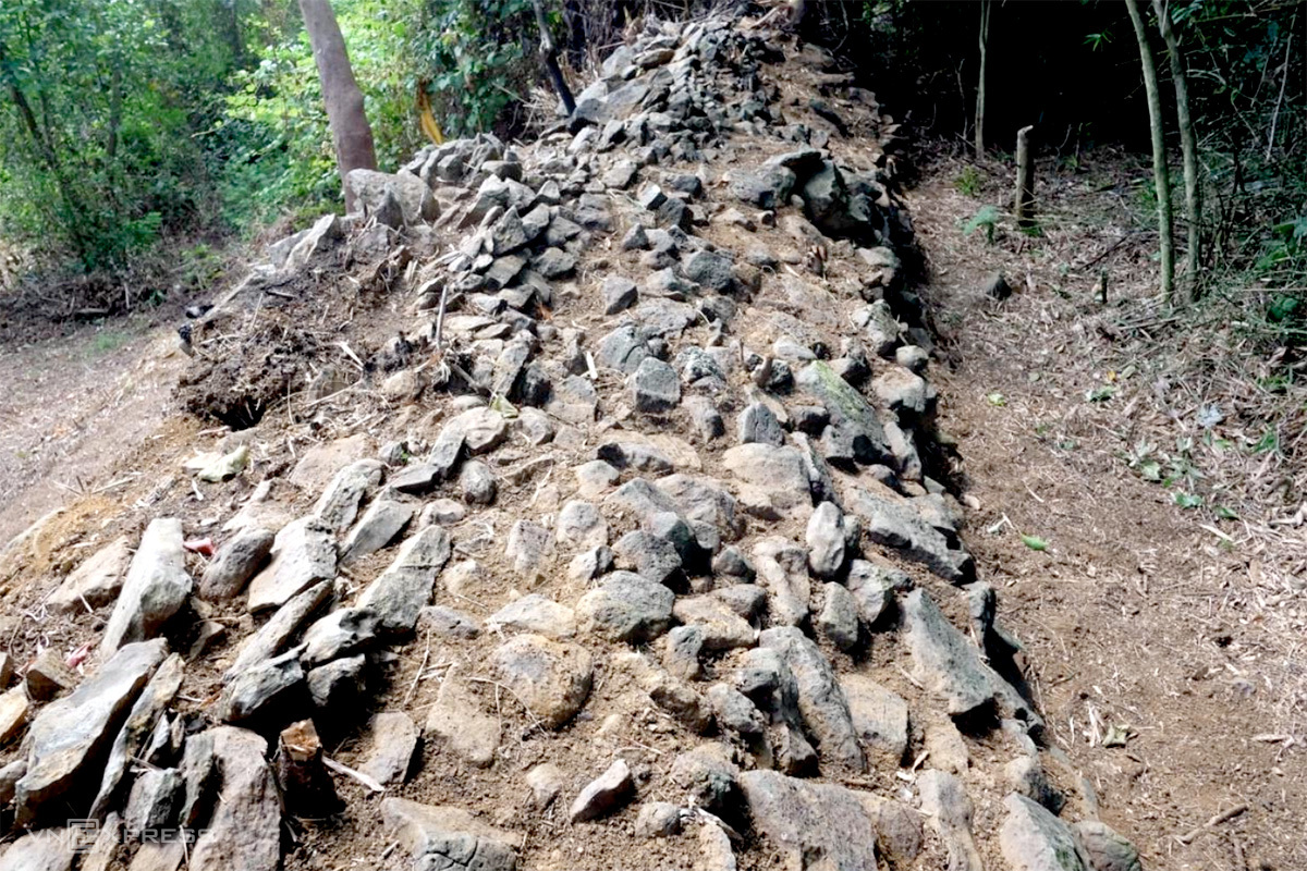 |
A section of the wall of Fort H4. Photo: Ngoc Oanh |
A section of the wall of Fort H4. Photo: Ngoc Oanh
Truong Luy not only served a military function but was also related to economics and culture. Nguyen dynasty historical records show that in addition to defense, this structure contributed to population management, tax collection, and trade regulation between the lowlands and highlands. In the early 19th century, the court also established the "nguon" (administrative units) of Tra Van and Tra Binh – special administrative units combining military and economic functions – to control the mountainous region west of Bong Son.
At the conference, many scholars said that although short, Truong Luy in Gia Lai still retains many intact architectural features and materials, providing valuable data for researching mountain forest defense art during the Nguyen dynasty. However, many issues remain unresolved, such as the exact length, construction time, participating forces, and the prioritized role between military and economic functions.
According to Dr. Nguyen Khanh Trung Kien, Deputy Director of the Southern Institute of Social Sciences, Truong Luy is a large-scale defensive system, completed under the reign of Gia Long. "The construction techniques demonstrate creativity, ensuring both defense and adaptation to the central region's terrain," he said.
 |
Dr. Nguyen Khanh Trung Kien speaking at the conference. Photo: Tran Hoa |
Dr. Nguyen Khanh Trung Kien speaking at the conference. Photo: Tran Hoa
Meanwhile, Dr. Nguyen Cong Thanh, from Quy Nhon University, suggested that Truong Luy in Gia Lai has not been fully studied, and the start date of construction needs clarification. He emphasized historical evidence indicating that the Nguyen dynasty only added the Binh Dinh rampart – the section now in Gia Lai – in 1876.
Currently, Truong Luy in Gia Lai has only been included in the provincial-level inventory of historical sites since 4/2025 and is not adequately protected. Many sections have been damaged by time, natural disasters, cultivation, and earth and stone exploitation. Preservation is difficult due to the structure's distribution across complex terrain, with some sections located on people's farmland, making demarcation and clearance challenging. The cost of surveying, marking, and protecting is also substantial.
Concluding the conference, Dr. Kien stated that the discussed opinions form an important basis for compiling a national-level historical site dossier, providing a legal basis for implementing protective measures. "Truong Luy in Gia Lai needs further in-depth research and appropriate preservation policies soon, before it is eroded by time and human impact," he emphasized.
Tran Hoa


