

The National Center for Hydro-Meteorological Forecasting reported this morning that the super typhoon is located in the northeast area of the north East Sea, with maximum sustained winds of 221 km/h, category 17, and gusts exceeding category 17. It's moving west-northwest at 20 km/h.
By 4 a.m. tomorrow, the super typhoon will be in the northern area of the East Sea, about 450 km east of the Leizhou Peninsula (China), with maximum sustained winds of category 16-17 and gusts exceeding category 17. The typhoon will maintain its course, but its speed will increase to 20-25 km/h.
By 4 a.m. on 25/9, the typhoon will be over southern Guangzhou province (China), with maximum sustained winds of category 12 and gusts of 15, maintaining its course and speed. The typhoon will then rapidly weaken into a tropical depression, and by 4 a.m. on 26/9, it will be over northern Vietnam, with maximum sustained winds of category 6 and gusts of 8.
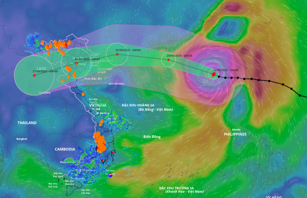 |
Forecast path and impact area of the super typhoon, morning of 23/9. Photo: *Disaster Monitoring System* |
The Japan Meteorological Agency reported that the super typhoon currently has sustained winds of 198 km/h. On 25/9, it will reach Leizhou with winds of 108 km/h, and its intensity will decrease as it enters the Gulf of Tonkin. The Hong Kong Observatory predicts the super typhoon will veer north of Leizhou, causing it to weaken rapidly.
Due to the typhoon's influence, the northern area of the north East Sea will experience strong winds of category 8-9, later increasing to 10-14. The area near the typhoon's eye will experience category 15-17 winds, with gusts exceeding category 17, and waves higher than 10 m. From 24/9, the eastern area of the Gulf of Tonkin (including Bach Long Vy island district) will experience increasing winds of category 6-7, with gusts of 9.
From the evening and night of 24/9, the Gulf of Tonkin (including Bach Long Vy special zone, Van Don, Co To, Cat Hai, and Hon Dau island) will experience increasing winds of category 8-9, with waves of 2-4 m. The area near the typhoon's eye will experience category 10-12 winds, with gusts of 14, and waves of 4-6 m. Coastal areas from Quang Ninh to Hai Phong will experience storm surges of 0.5-1 m.
Inland, from near dawn on 25/9, coastal areas from Quang Ninh to Thanh Hoa will experience increasing winds of category 6-7, later increasing to 8. Areas near the typhoon's center will experience category 9-10 winds, with gusts of 12. Further inland in northeast Vietnam, winds will reach category 6-7, with gusts of 8-9. From the night of 24/9 to 26/9, northern Vietnam, Thanh Hoa, and Nghe An will experience widespread rainfall of 100-250 mm, with some areas exceeding 400 mm. Urban flooding due to heavy rain is a concern.
On the afternoon of 22/9, at the National Steering Committee for Natural Disaster Prevention and Control meeting, Mai Van Khiem, Director of the National Center for Hydro-Meteorological Forecasting, said the super typhoon will rapidly weaken from 24/9 due to the influence of a continental high-pressure system and friction from China's terrain.
As it passes over the Leizhou Peninsula and enters the Gulf of Tonkin, the typhoon will weaken to category 11-12, with gusts of 14. Inland areas from Quang Ninh to Thanh Hoa may experience category 9-10 winds, with gusts of 14.
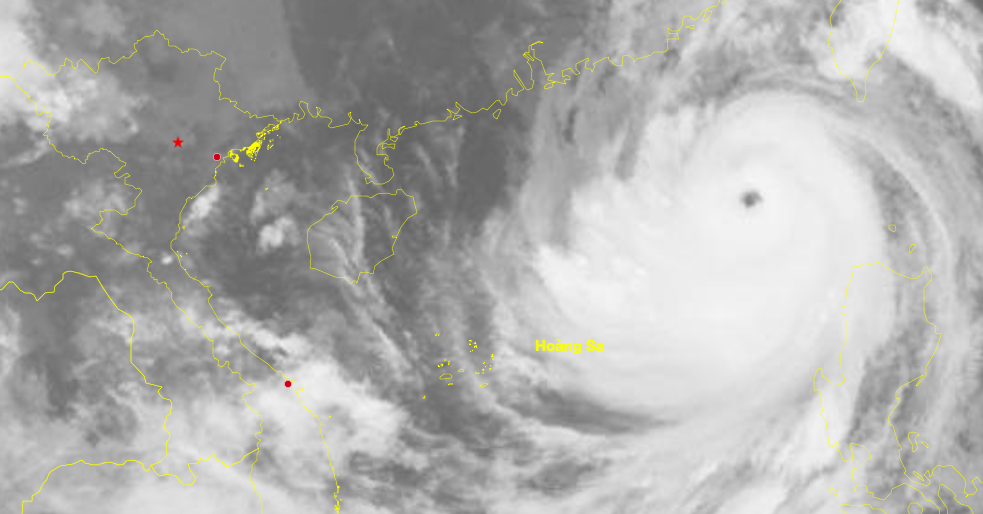 |
Satellite image of super typhoon Ragasa, at 6:50 a.m. on 23/9. Photo: *Hydro-Meteorological Administration* |
Yesterday afternoon, Deputy Prime Minister Tran Hong Ha signed an official dispatch requesting ministries, agencies, and localities from Quang Ngai northward to remain vigilant and prepare for super typhoon Ragasa with the utmost determination, taking proactive measures early and anticipating the worst-case scenario to ensure the safety of residents.
The government also requested coastal provinces and cities, especially from Quang Ninh to Hue, to postpone unnecessary meetings and mobilize the entire political system, providing timely updates to vessels about the typhoon's development to allow them to avoid it. Localities should base their actions on the specific situation to restrict or prohibit maritime activities and prepare forces, equipment, and evacuation plans as needed.
Super typhoon Ragasa formed from a tropical depression on the evening of 18/9 and intensified by 9 categories in four days. In 2024, the western North Pacific has already seen three super typhoons: Yagi, Gaemi, and Krathon. Yagi made landfall in Vietnam, causing strong winds, landslides, flash floods, and widespread flooding, resulting in 318 deaths, 26 missing persons, and nearly 84,000 billion VND in damage.
According to forecasts, from October to December, the number of typhoons and tropical depressions in the East Sea will be higher than the multi-year average, with more than 4 storms, of which two are likely to make direct landfall.
Gia Chinh


