

At 7 a.m. on 25/9, the National Center for Hydro-Meteorological Forecasting reported that Typhoon Bualoi was located east of the Philippines, with maximum sustained winds of 133 km/h, making it a category 12 typhoon with gusts reaching category 15. The typhoon is moving west-northwest at 15-20 km/h.
By the morning of 26/9, as it passes through the central Philippines, the typhoon is expected to strengthen to category 13, with gusts up to category 16. That evening, it's projected to enter the East Sea, becoming the 10th typhoon of the year. On the morning of 27/9, it is anticipated to maintain its intensity at category 12, with gusts of category 15.
Within the East Sea, the typhoon is likely to reorganize and intensify further. By 28/9, it's expected to reach category 12-13 in the middle of the East Sea, with gusts of category 16, moving west-northwest at 25 km/h.
The Japan Meteorological Agency reports Bualoi's current wind speed at 144 km/h, decreasing to 126 km/h upon entering the East Sea. However, it may regain strength to 162 km/h as it approaches the north-central coast of Vietnam. The Hong Kong Observatory forecasts a similar path, but with winds around 130 km/h near central Vietnam.
From the evening of 26/9, the eastern and central parts of the East Sea will experience strong winds of categories 6-7, increasing to categories 8-9. Near the typhoon's center, winds will reach categories 10-12, with gusts up to category 15. Wave heights are expected to reach 5-7 meters.
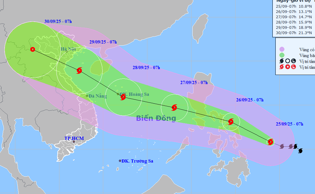 |
Forecast path of Typhoon Bualoi, morning of 25/9. Photo: NCHMF |
Forecast path of Typhoon Bualoi, morning of 25/9. Photo: NCHMF
Northern Vietnam is currently experiencing the effects of Typhoon Ragasa. After impacting Guangdong and the Leizhou Peninsula (China), Ragasa has weakened by four categories. At 7 a.m. today, the typhoon's center was located in Guangdong, approximately 100 km from Mong Cai (Quang Ninh), with maximum sustained winds of 74 km/h (category 8) and gusts of category 10.
Throughout 25/9, the typhoon is predicted to move west at 20 km/h along the coast of Guangdong and into the Gulf of Tonkin. It is expected to reach Mong Cai around noon with winds of category 8, with gusts increasing to category 11. From this evening, northern Vietnam, Thanh Hoa, and Nghe An will experience heavy rain. Coastal areas from Quang Ninh to Hai Phong will experience strong winds of category 8, with gusts reaching categories 9-10. By 4 p.m., the typhoon will weaken into a tropical depression over northeast Vietnam and by early tomorrow morning, it will become a low-pressure area over northwest Vietnam.
Dr. Truong Ba Kien, Deputy Director of the Center for Meteorological and Climate Research, Institute of Hydrometeorology and Climate Change, predicts that in the last three months of the year, the East Sea may experience 4-5 tropical cyclones, 2-3 of which will directly affect Vietnam, primarily central Vietnam.
According to Dr. Kien, the greatest risks during the remainder of the typhoon season are heavy rain causing flash floods and landslides in central Vietnam and the Central Highlands; storm surges, large waves, and high tides when strong typhoons make landfall; and consecutive storms causing repeated flooding, threatening the safety of dikes, dams, and reservoirs.
Gia Chinh


