

The National Center for Hydro-Meteorological Forecasting reported that at 4 p.m. today, the typhoon's center was located approximately 230 km east-northeast of the Paracel Islands, with maximum sustained winds of 102 km/h, category 9-10, and gusts reaching category 12.
Moving west-northwest at a speed of 25 km/h, by 4 p.m. tomorrow, the typhoon's center will be over the waters south of Hainan Island (China), with an intensity of category 12 and gusts of 14. By 2 p.m. on 25/6, the typhoon will reach category 12-13, with gusts of 15 over the waters from Thanh Hoa to Quang Tri, before making landfall in this region.
Meteorological authorities have identified a level 4 disaster risk (on a scale of 1 to 5) for the coastal areas from Thanh Hoa to Quang Tri, and for the inland areas from Thanh Hoa to northern Quang Tri. A level 3 risk has been issued for the western part of the South China Sea (including the Paracel Islands), the Gulf of Tonkin, and the waters from southern Quang Tri to Hue.
The Japan Meteorological Agency forecasts that the typhoon will intensify as it approaches land. If its current wind speed near the Paracel Islands is 108 km/h, it is expected to reach a maximum of 144 km/h. The Hong Kong Observatory has issued a similar intensity forecast and predicts that the typhoon will make landfall between Nghe An and Ha Tinh.
 |
Forecast track and impact area of Typhoon Kajiki at 4 p.m. today. Photo: NCHMF |
Forecast track and impact area of Typhoon Kajiki at 4 p.m. today. Photo: NCHMF
Mai Van Khiem, Director of the National Center for Hydro-Meteorological Forecasting, stated that Kajiki is dangerous due to the combined effects of very strong winds, exceptionally heavy rain, widespread flooding, flash floods, and landslides. The areas of greatest danger are Ha Tinh and northern Quang Tri. Residents should urgently reinforce their homes, evacuate if requested, and absolutely refrain from going out to sea during this period.
The northern South China Sea (including the Paracel Islands) is experiencing strong winds of category 8-9, with the area near the typhoon's center experiencing category 11-12 winds and gusts of 14, and waves of 4-6 m.
From tomorrow afternoon and evening, the waters from Thanh Hoa to Hue (including Hon Ngu Island and Con Co Island) will experience increasing winds from category 6 to 9-10, with areas near the typhoon's center experiencing category 11-13 winds and gusts of 15. Waves will reach 4-6 m, and 7-9 m near the typhoon's center.
From tomorrow afternoon, the northern Gulf of Tonkin (including Cat Hai, Co To, and Van Don Islands) will experience gradually increasing winds to category 6-7, with gusts of 9. The southern part of the northern Gulf of Tonkin (including Bach Long Vi Island) will experience winds of category 8, with gusts of 10.
Coastal areas from Ninh Binh to northern Quang Tri will experience storm surges of 0.5-1.2 m. Water levels at Sam Son (Thanh Hoa) will be 3.2-3.6 m, at Hon Ngu (Nghe An) 3.3-3.8 m, at Vung Ang (Ha Tinh) 2.2-2.8 m, and at Cua Gianh (Quang Tri) 1.5-2 m. There is a high risk of flooding in low-lying areas, estuaries, and islands from Thanh Hoa to northern Quang Tri.
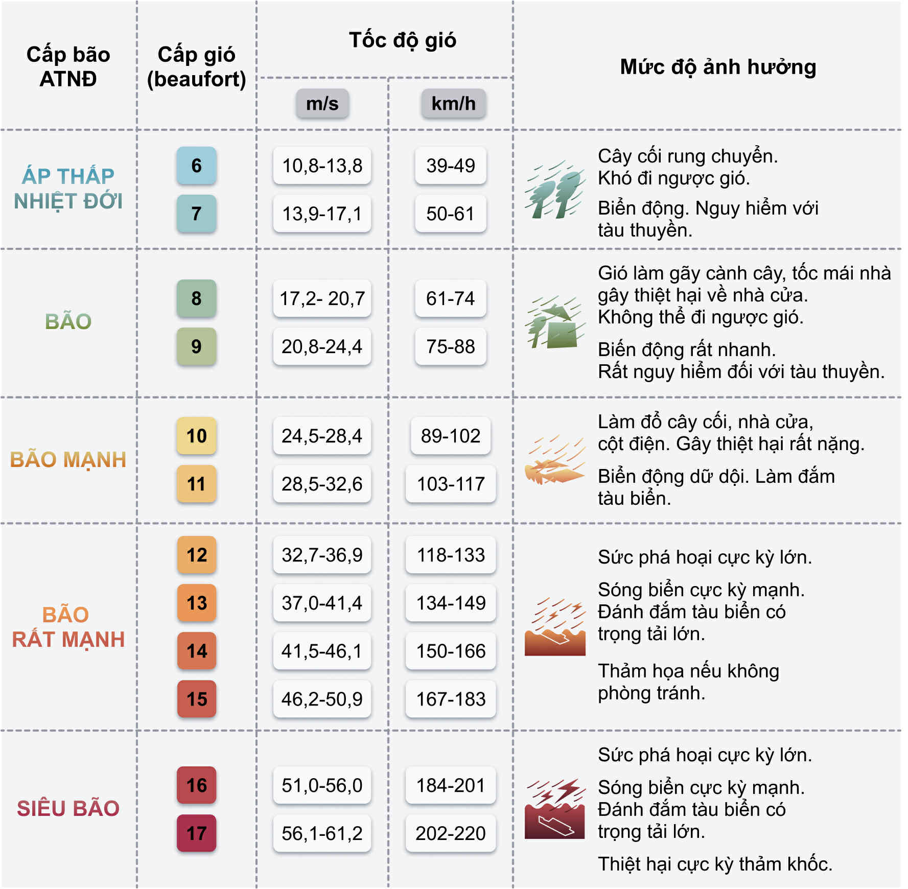 |
Typhoon warning scale. Photo: Duy Khanh |
Typhoon warning scale. Photo: Duy Khanh
Meteorological authorities warn that sea and coastal land conditions during the typhoon will be extremely dangerous and unsafe for any vehicles or structures. There is a high risk of vehicles capsizing or being destroyed, and flooding due to strong winds, large waves, and storm surges.
From tomorrow night, inland areas from Thanh Hoa to Quang Tri will experience increasing winds to category 7-9, with areas near the typhoon's center experiencing category 10-12 winds and gusts of 14-15. Coastal areas from Quang Ninh to Ninh Binh will experience increasing winds to category 6-7, with gusts of 8.
Heavy rain from the typhoon will begin tomorrow night and continue until the end of 26/8. The northern delta, southern Phu Tho, and the region from Thanh Hoa to Hue will receive 100-150 mm of rainfall, with some areas receiving over 250 mm. Thanh Hoa to northern Quang Tri will receive 200-400 mm, with some areas receiving over 700 mm. There is a high risk of intense rainfall exceeding 200 mm in three hours.
Hanoi, Da Nang, and Ho Chi Minh City will also experience rain on 25-26/8. In addition, from 25-27/8, upper and central Laos are also likely to experience heavy rain of 100-250 mm, with some areas receiving over 500 mm. Heavy rain in Laos poses a risk of landslides and flash floods in mountainous areas of the central provinces.
Kajiki formed from a low-pressure area over Luzon Island in the Philippines. On the morning of 22/8, it intensified into a tropical depression and then a typhoon a few hours later. The typical lifespan of a typhoon is 7-8 days, and Kajiki, being only three days old, is still very "young and strong," so its impact potential is very high.
Prior to Kajiki, there have been 4 typhoons in the South China Sea this year. The most recent, Typhoon Wipha, made landfall between Hung Yen and Ninh Binh on 22/7. This category 9-10 typhoon brought heavy rain, especially to Thanh Hoa and Nghe An provinces, resulting in two deaths from flash floods and landslides, and five injuries.
Gia Chinh


