

At 7 a.m. today, the National Center for Hydro-Meteorological Forecasting reported that the typhoon was located in the northwest of the Paracel Islands, about 620 km east of Nghe An and 600 km east of Ha Tinh. It had maximum sustained winds of 133 km/h, category 12, with gusts up to 15.
Moving northwest at 20 km/h, the typhoon is expected to be in the southern Gulf of Tonkin by 7 a.m. tomorrow, approximately 160 km from Nghe An and 140 km from Ha Tinh, with an intensity of category 12-13 and gusts up to 15.
The typhoon's center is predicted to hit Nghe An and Ha Tinh tomorrow afternoon. The meteorological agency has issued a level 4 disaster risk warning (on a scale of 1 to 5) for the coastal areas of Thanh Hoa to Quang Tri, and for inland areas from Thanh Hoa to northern Quang Tri. A level 3 warning is in effect for the Gulf of Tonkin and the southern waters of Quang Tri to Hue (including Hon Ngu island and Con Co special administrative-economic unit).
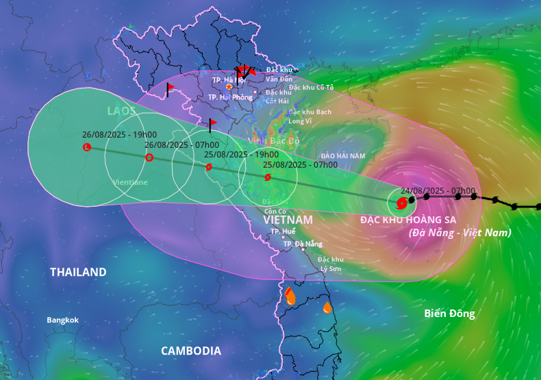 |
Forecast track and impact area of Typhoon Kajiki. Photo: Disaster Monitoring System |
Forecast track and impact area of Typhoon Kajiki. Photo: Disaster Monitoring System
The Japan Meteorological Agency reports that the typhoon currently has sustained winds of 126 km/h and is expected to increase to 144 km/h today. The Hong Kong Observatory made a similar assessment regarding intensity and predicted landfall between Nghe An and Ha Tinh.
Due to the typhoon, the northwestern area of the South China Sea (including the Paracel Islands) is experiencing winds of category 8-10, with category 11-13 near the typhoon's center and gusts up to 15. Waves are expected to reach 5-7 m, and 7-9 m near the center.
From this afternoon, winds in the waters from Thanh Hoa to Hue (including Hon Ngu island and Con Co special administrative-economic unit) will gradually increase to category 6-8, then to 9-10, with category 11-13 where the typhoon's center passes and gusts up to 15. Waves are expected to reach 4-6 m, and 7-9 m near the center.
The northern Gulf of Tonkin (including Cat Hai, Co To, and Van Don special administrative-economic units) will experience winds increasing to category 6-7 with gusts up to 9; while the southern part of the northern Gulf of Tonkin (including Bach Long Vi special administrative-economic unit) will experience winds of category 8, with gusts up to 10. Wave heights will be 2-4 m.
Coastal areas and islands from Hai Phong to Ha Tinh are expected to see storm surges of 0.5-1.5 m. Water levels at Hon Dau (Hai Phong) are predicted to be 3.3-3.8 m, Ba Lat (Ninh Binh) 1.7-2.1 m, Sam Son (Thanh Hoa) 3.2-3.7 m, Hon Ngu (Nghe An) 3.2-3.6 m, and Cua Nhuong (Ha Tinh) 2.2-2.6 m. There is a high risk of flooding in low-lying areas and estuaries due to storm surge and large waves tomorrow afternoon and evening.
The meteorological agency warns that sea and coastal conditions during the typhoon will be extremely dangerous, unsafe for any vessels or structures. There is a high risk of capsizing and damage to vessels due to strong winds, high waves, and storm surge.
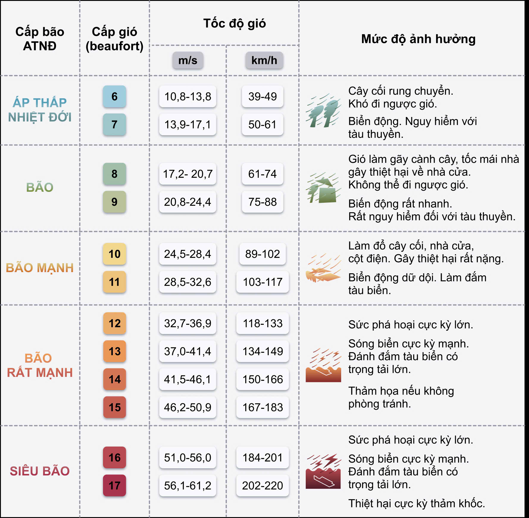 |
Typhoon categories and warning levels. Graphic: Duy Khanh |
Typhoon categories and warning levels. Graphic: Duy Khanh
Inland areas from Thanh Hoa to Quang Tri will experience increasing winds from tonight, reaching category 7-9, with category 10-12 near the typhoon's center and gusts of 14-15. Coastal areas from Quang Ninh to Ninh Binh will experience winds increasing to category 6-7 with gusts up to 8.
Heavy rain from the typhoon will begin tonight and continue until 26/8. The Red River Delta, southern Phu Tho, and Thanh Hoa to Hue are forecast to receive 100-150 mm of rain, with some areas receiving up to 250 mm. Thanh Hoa to northern Quang Tri could see 200-400 mm, with isolated areas exceeding 700 mm. There is a risk of intense rainfall exceeding 200 mm in three hours.
From 25-26/8, Hanoi and Da Nang will experience thunderstorms. Upper and Central Laos will receive 100-250 mm of rain, with some areas in Central Laos exceeding 500 mm.
Coastal provinces from Ninh Binh to Thua Thien Hue have issued sea bans, prohibiting vessels from going out to sea. Returning vessels are being arranged for safe anchorage to prevent collisions and sinking. Since yesterday, local authorities have been proactively releasing water from hydropower reservoirs and irrigation systems to ensure dam safety and reduce the risk of severe flooding due to post-typhoon rainfall.
Four working groups led by the Ministry of Agriculture and Rural Development and the Ministry of National Defense are currently in Thanh Hoa, Nghe An, Ha Tinh, and Quang Tri to coordinate with local authorities in typhoon response efforts.
Kajiki is the fifth typhoon to form in the South China Sea this year. It originated from a low-pressure area near Luzon, Philippines, and rapidly intensified into a tropical depression and then a typhoon upon entering the South China Sea on 23/7.
Gia Chinh


