

As of 7 PM, the National Center for Hydro-Meteorological Forecasting reported that Typhoon Ragasa is located in Guangdong province, China, approaching the Leizhou Peninsula and approximately 375 km east of Mong Cai city, Quang Ninh province, Vietnam. The typhoon packs sustained winds of 133 km/h near its center, with gusts up to category 15. It is moving west-northwest at about 20 km/h.
The typhoon is expected to enter the Gulf of Tonkin tonight. By 7 AM tomorrow, it will be about 100 km east of Mong Cai, with winds decreasing to categories 8-9 and gusts up to category 11. The typhoon will maintain its speed but shift its course westward.
After making landfall near Mong Cai, the typhoon will move further inland and weaken into a tropical depression over Northeast Vietnam by 7 PM tomorrow. It will then continue westward and dissipate over Northwest Vietnam.
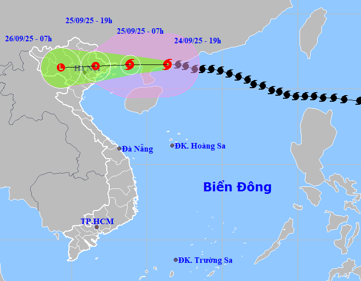 |
Projected path and area of influence of Typhoon Ragasa, evening of 24/9. Image: NCHMF |
The Japan Meteorological Agency reports that the typhoon is currently north of the Leizhou Peninsula with winds of 144 km/h and is expected to reach Quang Ninh province, Vietnam tomorrow with winds of 72 km/h. The Hong Kong Observatory reports slightly higher current wind speeds of 155 km/h, predicting the typhoon will hit near Bac Ninh province with winds around 65 km/h.
The Vietnamese meteorological agency has increased its rainfall warning. From tonight until the end of 26/9, Northern Vietnam, Thanh Hoa, and Nghe An provinces are forecast to receive 150-300 mm of rain, with some areas exceeding 450 mm. Urban flooding is a concern.
From tomorrow until 27/9, rivers in Northern Vietnam, Thanh Hoa, and Nghe An are likely to experience flooding. Water levels on the Thao River and smaller rivers are predicted to reach warning levels two and three. The Lo River, the upper reaches of the Thai Binh River, Hoang Long River, Buoi River, and the upper reaches of the Ma River are expected to reach warning levels one and two, with some potentially exceeding level two.
Wind speeds in the northwestern part of the East Sea (South China Sea) will reach categories 8-10, with categories 11-12 near the typhoon’s center, and gusts up to category 15. Waves will reach 6-8 meters. In the northern Gulf of Tonkin (including Bach Long Vy, Van Don, Co To, Cat Hai, and Hon Dau island), winds are expected to reach categories 6-8 with waves of 2-4 meters. Near the typhoon’s center, winds will be categories 9-10, with gusts up to category 12 and waves of 3-4 meters.
Starting tomorrow morning, coastal areas from Quang Ninh to Hung Yen provinces will experience increasing winds of categories 6-7, with category 8 near the typhoon’s center and gusts of categories 9-10. Inland areas of Northeast Vietnam will experience winds of category 5, reaching category 6 in some places, with gusts of categories 7-8.
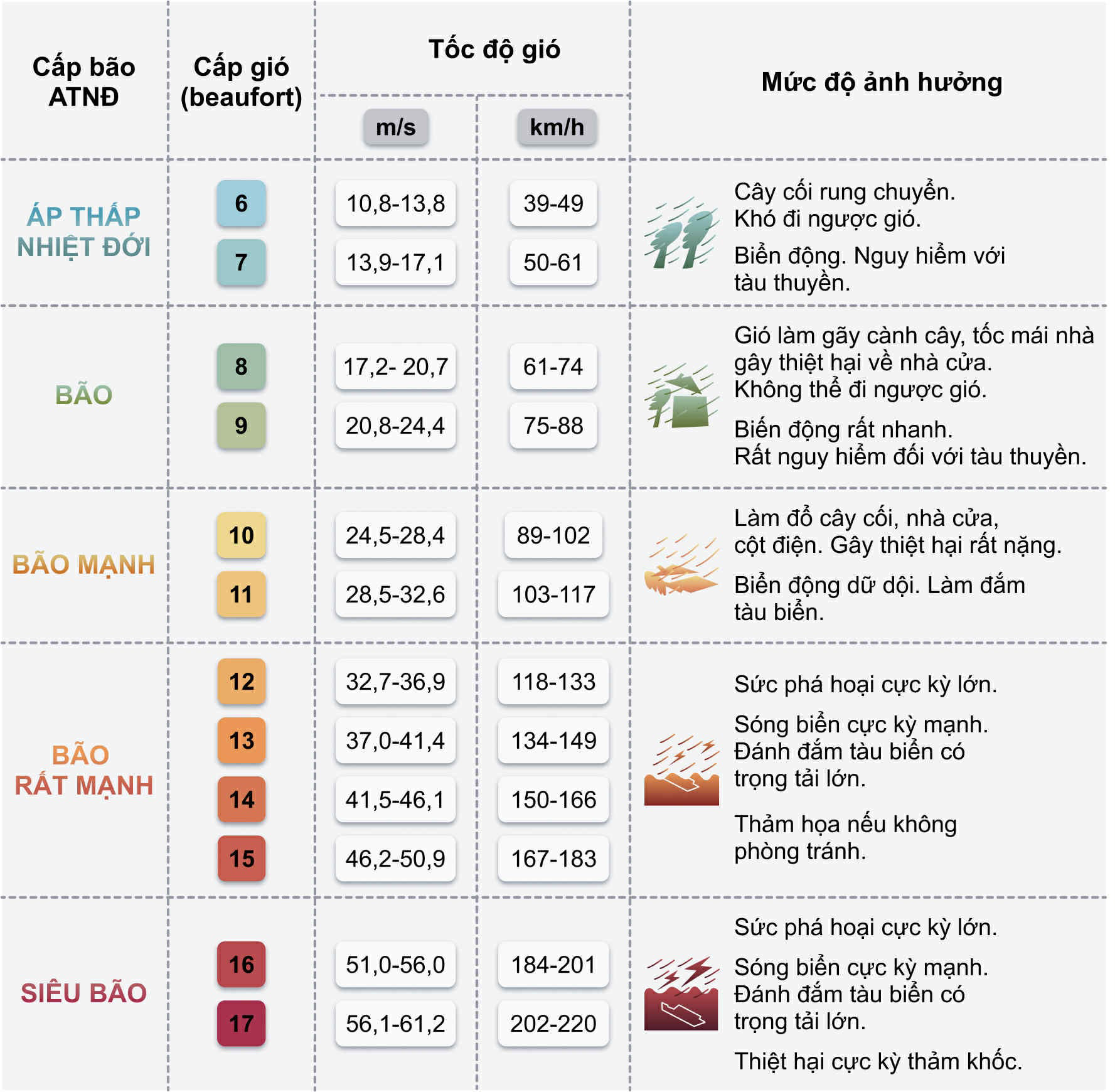 |
Typhoon categories and impact levels. Graphics: Hoang Khanh |
In response to Typhoon Ragasa, the Vietnamese government has issued two official dispatches. Quang Ninh, Hung Yen, and Hai Phong provinces have banned ships from going out to sea since noon on 24/9 and urged vessels to seek safe harbor.
Typhoon Ragasa previously swept through Taiwan, causing heavy rains that led to the collapse of a reservoir on the Ma Thai An River. The resulting floodwaters carried debris downstream, destroying a bridge over the river and causing widespread flooding in several towns, submerging houses, and sweeping away vehicles.
Taiwan's fire department reported 15 deaths and 17 people missing due to the floods. The typhoon then hit the coastal city of Jiangmen in Guangdong province, China, with winds of 241 km/h, surpassing the 196 km/h record set by Typhoon Mangkhut in 2018.
Gia Chinh


