The Hanoi People's Committee is seeking public feedback on a comprehensive adjustment proposal for the Red River urban subdivision plan (1/5,000 scale). This plan is crucial for implementing the Red River Landscape Boulevard Investment Project. The planning is being developed as Hanoi reviews its development orientations for both sides of the Red River, specifically detailing the Capital's General Plan to 2045, with a vision to 2065, and reorganizing residential areas outside the dike. The Red River Landscape Boulevard is identified as one of the capital's nine key development axes.
Plan aims to resolve numerous riverside urban issues
According to Hanoi, the plan's adjustment stems from existing challenges in developing the Red River's banks. Many riverside residential areas frequently suffer from flooding. The drainage system remains limited, and wastewater and solid waste in some areas are not yet managed comprehensively.
The spaces along the river have also not fully leveraged their landscape, ecological, cultural, and economic values. Potential sectors such as urban agriculture, riverside tourism, waterway transport, and craft villages remain underdeveloped. The multimodal transport network and waterway transport are still in early stages.
With this comprehensive adjustment, the plan aims to simultaneously address flood control, infrastructure, transport, environmental issues, community reorganization, and the exploitation of economic and cultural values in the riverside area. This also forms the basis for redefining land use functions, green space systems, transport networks, and urban development areas in subsequent phases.
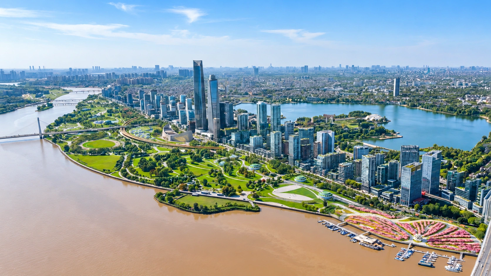 |
Perspective of the Red River urban subdivision plan. Photo: Hanoi People's Committee |
40 km planning research scope
The plan's research scope extends approximately 40 km in a northwest-southeast direction, from Hong Ha Bridge to Me So Bridge, covering one-third of the Red River's total length within Hanoi. The northern boundary is the Left Red River dike, and the southern boundary is the Right Red River dike. The entire area spans about 11,418 ha, encompassing parts of 9 communes and 7 wards, including: Hong Ha, O Dien, Thuong Cat, Dong Ngac, Phu Thuong, Linh Nam, Thanh Tri, Nam Phu, Hong Van, Me Linh, Thien Loc, Vinh Thanh, Dong Anh, Bo De, Long Bien, and Bat Trang.
Regarding spatial organization, Hanoi has established principles for reorganizing and planning residential areas outside the dike and synchronizing the spaces along both sides of the Red River. New urban spaces and service facilities are positioned along main roads. High-rise zones are arranged linearly, with low construction density and heights gradually decreasing towards the dike, ensuring views and favorable microclimates.
Buffer zones are created between high-rise urban areas and villages to facilitate spatial transition. The plan also leverages the landscapes of traditional craft villages for eco-tourism, supplementing and upgrading educational, medical, and cultural facilities, along with green land. A chain of urban parks will be formed along the riverbanks, connecting with urban areas via east-west green axes.
Natural conservation parks are designated in frequently flooded areas outside the secondary dike. Specifically, in areas adjacent to the historic inner city, integrated functional spaces are planned to connect with cultural and historical sites such as Long Bien Bridge and the West Lake - Co Loa axis.
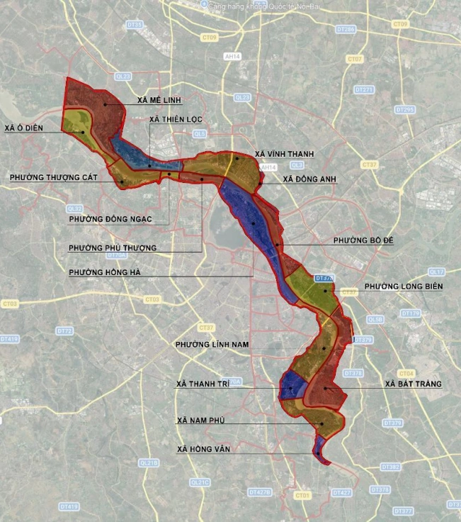 |
16 communes and wards along the Red River. Source: Hanoi People's Committee |
Three distinct segments with specific roles
According to the adjustment proposal, the entire area's architectural space structure is divided into three segments for management and development. Segment 1, from Hong Ha Bridge to Thang Long Bridge, covers about 3,436 ha and has a population of 160,000. This area is designated for ecological space, natural preservation, theme parks, sports parks, and landscape greenery.
Existing villages and hamlets will be improved and upgraded in the short term, except for those within relocation zones specified by the Flood Control Plan or affected by the landscape boulevard and interchanges. Simultaneously, the area will develop multifunctional, commercial, service, and transport facilities at the Chem port cluster and various housing groups.
Segment 2, from Thang Long Bridge to Thanh Tri Bridge, covers about 4,548 ha and has a population of approximately 541,000. This is the central area of the subdivision, identified as the "Urban Living Room", with public, cultural, commercial, service functions, and landscape spaces. The plan proposes extensive redevelopment, adding commercial, service, concentrated cultural institutions, and landmark structures that link the West Lake - Co Loa area.
Segment 3, from Thanh Tri Bridge to Me So Bridge, covers about 3,435 ha and has a population of approximately 499,000. This area is designated for commercial, service, transport, ecological agricultural parks, and resort development combined with creative experiences. The plan also requires the preservation and restoration of historical and cultural values for tourism; and the development of multifunctional areas linked to Thanh Tri and Bat Trang ports and craft villages.
Across all three segments, the planning and architectural guidelines specify a maximum height of 30-45 stories; construction density for service-public areas is 60%, housing groups 35-40%, public parks 5%, and theme parks 25%.
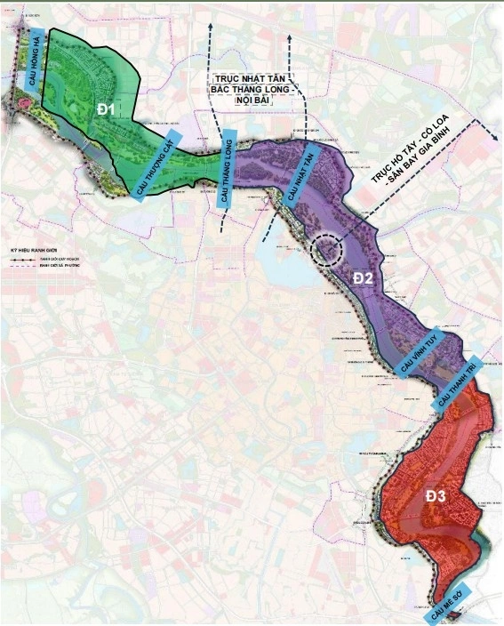 |
Spatial structure divided into three segments with distinct functions. Source: Hanoi People's Committee |
Not all villages to be relocated
For existing residential areas, Hanoi has reviewed 12 craft village clusters totaling approximately 1,067 ha. Of this, about 67 ha are designated for relocation under the Flood Control Plan; about 50 ha are affected by the landscape boulevard axis; about 108 ha are slated for redevelopment; and about 842 ha are identified for renovation and upgrading.
The proposal also specifically categorizes long-standing villages, craft villages, and traditional craft villages. There are 8 village clusters for selective renovation, two for redevelopment, and two for relocation according to the flood control plan.
Along with the transport routes, the plan also allocates a chain of parks at various locations along the river. The list of component projects includes the Trang Viet, Tam Xa, Ngoc Thuy, Long Bien - Cu Khoi, Thuong Cat - Lien Mac, O Dien, Phu Thuong, Hong Ha, Linh Nam, Linh Nam - Nam Phu - Hong Van, and Xuan Quan - Phung Cong park clusters.
These park areas are situated alongside urban development zones, settlements, craft village redevelopment areas, and other functional zones. In segment 1, projects include the Trang Viet, Thuong Cat - Lien Mac, O Dien park clusters, and urban development land in Me Linh, Thien Loc, and Thuong Cat.
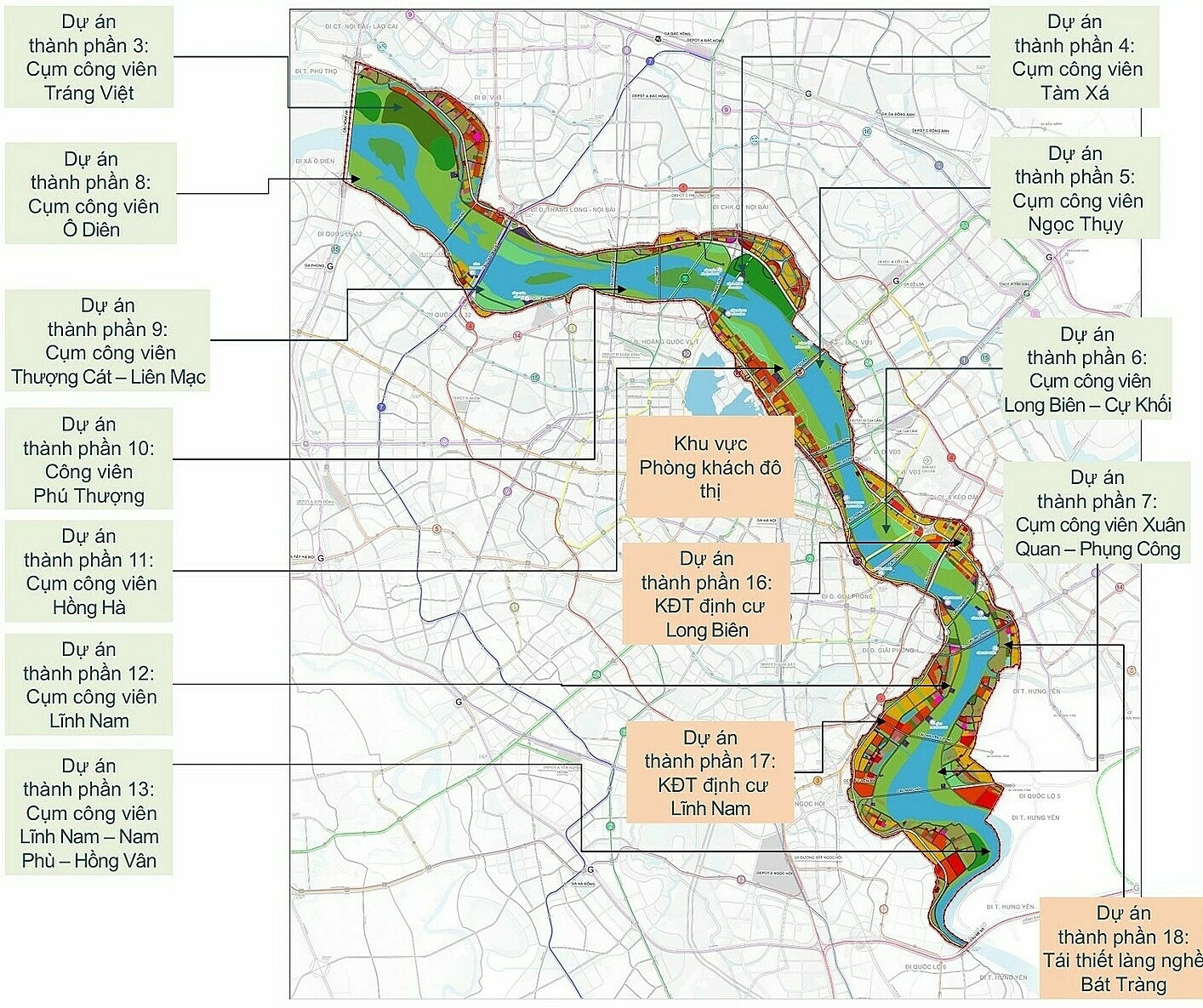 |
Component projects in the Red River urban subdivision. Photo: Hanoi People's Committee |
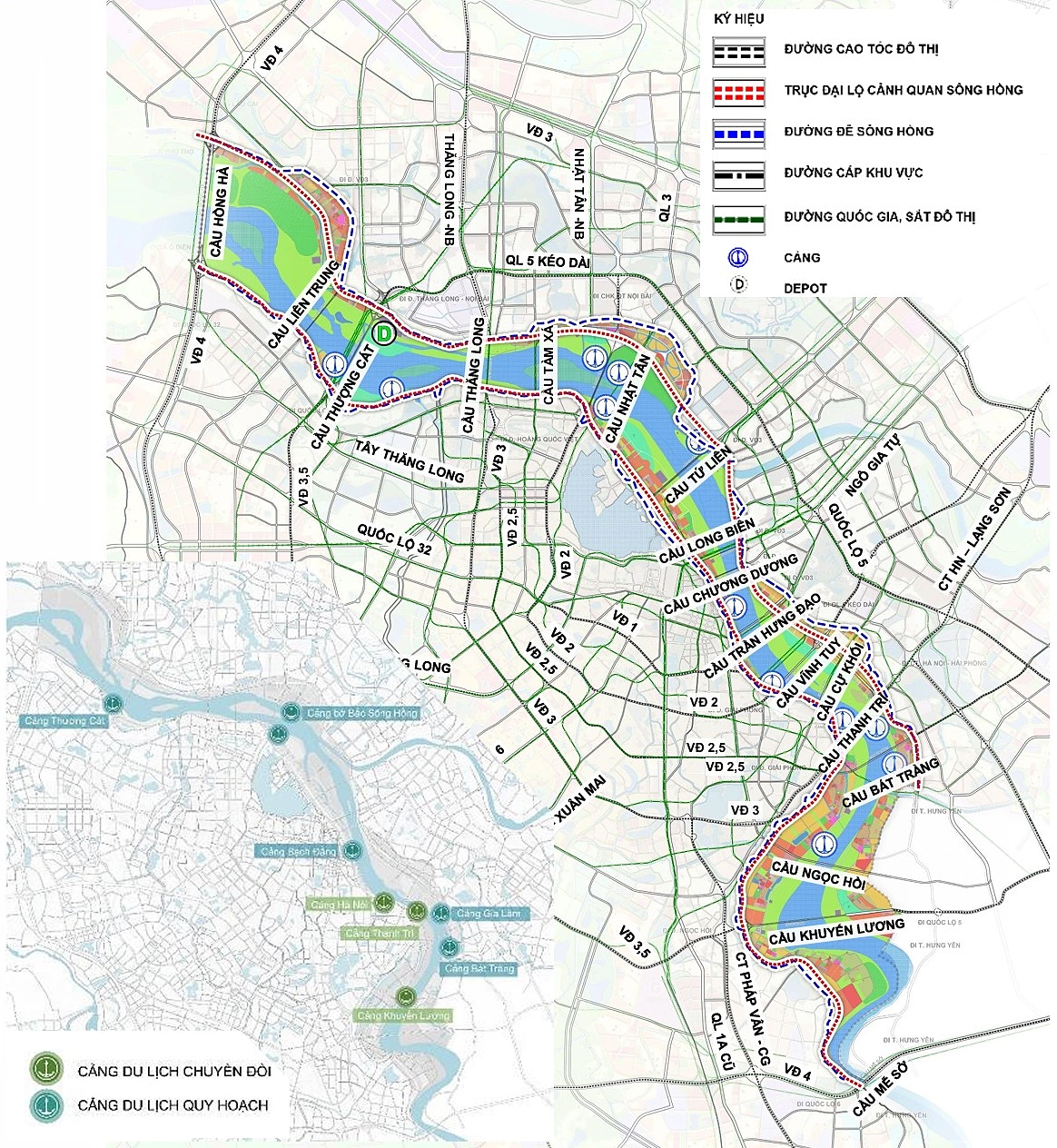
Regarding transportation, the Red River urban subdivision plan integrates various modes: roads, railways, waterways, and public transport. The Red River Landscape Boulevard serves as the main road running along both sides of the river. The Left Red River route, approximately 35 km long, and the Right Red River route, approximately 45,35 km long, are both designated as urban main axes with a main road section featuring 6 motor vehicle lanes.
Additionally, urban and inter-regional main roads will have 6-8 lanes, with widths of 40-50 m; regional roads will have 2-4 lanes, with widths of 17,5-30 m. River crossings will be facilitated by 17 road bridges: including 6 existing bridges (Thang Long, Nhat Tan, Long Bien, Chuong Duong, Vinh Tuy, and Thanh Tri); 6 bridges currently under construction (Hong Ha, Thuong Cat, Tu Lien, Tran Hung Dao, Ngoc Hoi, and Me So); and 5 planned bridges (Lien Trung, Tam Xa, Cu Khoi, Bat Trang, and Khuyen Luong).
For waterways, the plan aims to upgrade the port system, improve channels, and gradually convert the function of cargo ports into tourist ports, combining them with service points. A waterbus route is proposed to run along the river, connecting both banks and riverside landmarks, tourism spaces, while also linking with the road network according to spatial development orientations.
Concerning railways, the national railway network is slated for upgrading, renovation, and the construction of new radial and ring lines, including the ring road 4 railway line connecting at Hong Ha and Me So bridges. The urban railway network passing through the area comprises 11 lines: lines 1, 2, 4, 5, 6, 7, 8, 10, 14, 15, and 2A.
The bus system will be integrated with the urban railway, connecting to stations; stops will be located on regional-level roads and above, with distances of approximately 300-500 m and a maximum of 800 m. The plan also includes public parking lots combined with green areas, public spaces, grade-separated interchanges, and areas under viaducts; new construction projects must meet the parking demand of the structure and a portion of the area's demand.
 |
Transport infrastructure in the Red River urban subdivision plan. Photo: Hanoi People's Committee |
18 component projects of the plan
Hanoi states that the plan will be realized through 18 component projects, comprising two transport infrastructure investment projects; 11 park investment projects; two riverbank and riverbed reinforcement and regularization projects; and three urban settlement and redevelopment projects.
The proposed timeline for these projects is from 2026 to 2038. During giai doan 2026-2030, the city will prioritize the Red River Landscape Boulevard on both sides, riverbank and riverbed reinforcement, several parks, the "Urban Living Room" area, urban settlements in Linh Nam and Long Bien, and independent site clearance projects. Giai doan 2030-2038 will see the completion of the remaining component projects.
The proposal identifies six core values: safety, building a riverside city that develops harmoniously with water, ecology, transport, function, economy, and culture-civilization. It also sets requirements for flood control foundations, synchronized infrastructure, functional transformation, and quality enhancement.
The plan's objectives include implementing tasks outlined in Resolution 2 dated 17/3/2026; aiming for the Red River to become a socio-economic development axis and a symbol of Hanoi's "Culture - Identity - Creativity". The city will develop a phased plan to relocate, reorganize, and re-plan communities outside the dike; simultaneously serving as a basis for identifying investment and detailed planning projects.
Son Ha