At 4 a.m., the National Center for Hydro-Meteorological Forecasting reported the tropical depression was about 320 km east-southeast of Quang Tri and 220 km east-northeast of Hue. The depression is expected to strengthen into a typhoon this morning.
By 1 p.m. today, the typhoon is predicted to be over the Quang Tri - Hue sea area, with maximum sustained winds of level 8, and gusts up to level 10. It is expected to move west-northwest at a steady speed. The typhoon will then make landfall in the Quang Tri - Hue area and weaken into a low-pressure area over central Laos.
Both the Japan Meteorological Agency and the Hong Kong Observatory assess that the tropical depression, after strengthening into a typhoon, will not intensify further. Landfall in the Quang Tri - Hue area is expected tonight or early tomorrow morning.
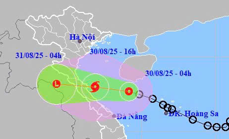 |
Forecast track and impact area of the tropical depression. Photo: NCHMF |
Forecast track and impact area of the tropical depression. Photo: NCHMF
Due to the influence of the tropical depression, which is likely to strengthen into a typhoon, the coastal area of the northwestern South China Sea (including the Hoang Sa archipelago) will experience strong winds of level 6-7 and waves of 2-4.5 m. The Thanh Hoa - Hue sea area (including Hon Ngu island and Con Co special administrative-economic unit) will see winds gradually increase to level 6-7, with the area near the typhoon's center experiencing winds up to level 8 and gusts up to level 10. Waves will reach 2-4 m, and up to 3-5 m near the typhoon's center. Coastal areas of Nghe An - Hue provinces will experience a surge of 0.2-0.4 m.
The meteorological agency warns that sea and coastal land conditions will be very dangerous, posing a safety risk to vessels and structures operating in the affected area, including tourist boats, passenger ships, cargo vessels, cages, rafts, and aquaculture farms.
Starting this morning, the coastal areas from Nghe An to Quang Tri will see winds gradually increase to level 6, with gusts up to level 8.
The coastal area from Ha Tinh to northern Quang Tri will experience winds of level 6-7, increasing to level 8 near the typhoon's center, with gusts up to level 10. Strong thunderstorms and tornadoes are possible before the tropical depression and typhoon make direct impact.
From now until the end of tomorrow, rainfall in Thanh Hoa - Hue is expected to reach 150-300 mm, and over 500 mm in some areas. The midlands and delta of northern Vietnam, as well as Da Nang, will receive 100-200 mm of rain, with some areas exceeding 400 mm.
There have been 5 typhoons in the South China Sea since the beginning of the year. On 26/8, Typhoon Kajiki made landfall in the Thanh Hoa - Ha Tinh area with winds of level 10-11, gusting to level 13, causing significant damage not only in north-central Vietnam but also triggering heavy rains and flooding in northern Vietnam, leading to landslides in many locations.
The Steering Committee for Natural Disaster Prevention and Control reported that as of 28/8, the storms and floods had resulted in 6 deaths, two missing persons, and 47 injuries. 34 houses collapsed, and nearly 31,100 houses had their roofs blown off, mainly in Ha Tinh province, with nearly 25,000 affected houses, and nearly 4,000 houses flooded. 407 schools, 48 medical facilities, 72 office buildings, and cultural structures suffered roof damage or were destroyed.
The typhoon also damaged approximately 95,000 ha of rice paddies, mainly in Nghe An, Ha Tinh, and Ninh Binh, over 11,000 ha of vegetable crops, and 9,700 ha of fruit trees, which were either flooded or destroyed. Over 53,000 livestock and poultry, 4,000 ha of aquaculture, and 274 cages and rafts were also affected.
Transportation authorities recorded 456 landslides in the provinces of Son La, Bac Ninh, Phu Tho, Thanh Hoa, Nghe An, Ha Tinh, and Quang Tri, and 13 damaged bridges. The power system was severely impacted, with 1.6 million customers experiencing power outages at the peak.
Gia Chinh


