

At 1 a.m. on 23/8, the National Center for Hydro-Meteorological Forecasting reported the tropical depression was located approximately 730 km east of the Paracel Islands, with maximum sustained winds of 61 km/h (level 7) and gusts up to level 9. It was moving west-northwest at 25 km/h.
The tropical depression is expected to intensify into a typhoon today. By 1 a.m. tomorrow, it is projected to reach level 9, with gusts up to level 11, over the northeastern waters of the Paracel Islands, maintaining its course while slowing to 20 km/h.
By 1 a.m. on 25/8, the typhoon is predicted to reach level 11-12, with gusts up to level 15, over the waters off Nghe An - Hue.
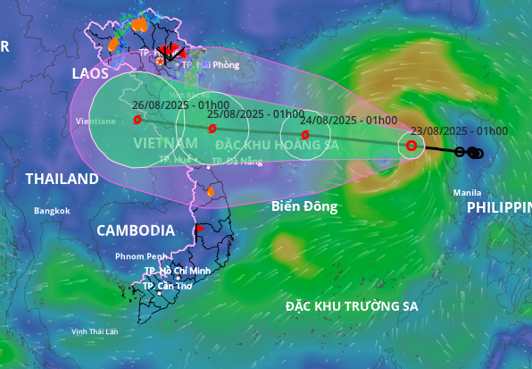 |
Projected path and area of influence of the tropical depression. Photo: Disaster Monitoring System |
Projected path and area of influence of the tropical depression. Photo: Disaster Monitoring System
The Japan Meteorological Agency predicts the tropical depression will continuously strengthen after becoming a typhoon. While near the Paracel Islands, wind speeds are estimated at 82 km/h, increasing to 126 km/h near the waters off Nghe An - Hue. The Hong Kong Observatory suggests the typhoon will reach a peak intensity of 130 km/h, with its center making landfall near Vinh (Nghe An).
Due to the tropical depression's influence, the northern South China Sea (including the Paracel Islands) is experiencing strong winds of level 6-7, expected to increase to level 8. Areas near the typhoon's center will experience levels 9-10, with gusts up to level 12, and waves of 3-5 m, increasing to 4-6 m near the center. Vessels operating in these dangerous areas are likely to be affected.
In a response meeting yesterday morning, the Ministry of Agriculture and Rural Development assessed the tropical depression would strengthen into a typhoon and intensify rapidly. On 24/8, upon reaching the Paracel Islands, the typhoon could reach level 10-11, with gusts of level 13-14, and potentially strengthen further upon entering the southern waters of the Gulf of Tonkin. Landfall is expected on 25/8.
Mai Van Khiem, Director of the National Center for Hydro-Meteorological Forecasting, assessed that, based on the current scenario, the typhoon's circulation will have a broad impact, affecting the northern and north-central coasts. The coastal area from Nghe An to Quang Tri will bear the brunt of the typhoon's force, potentially experiencing winds of level 10-11, with gusts up to level 13-14.
From the night of 24/8 to the end of 27/8, the meteorological agency forecasts very heavy rain from Thanh Hoa to Hue, with widespread rainfall totals of 150-300 mm, and some areas exceeding 600 mm.
Last night, Deputy Prime Minister Tran Hong Ha issued an official dispatch requesting coastal provinces and cities from Quang Ninh to Gia Lai, along with relevant ministries and agencies, to implement response measures to the tropical depression and its potential intensification into a typhoon. Provinces and cities are instructed to closely monitor the tropical depression's development, review vessels at sea, and take precautions against pre-typhoon thunderstorms and tornadoes. They are also to review response scenarios and proactively evacuate residents from high-risk areas prone to landslides and flash floods.
The Deputy Prime Minister also requested agencies to closely monitor and scientifically operate hydropower and irrigation reservoirs to ensure safety. Provinces are instructed to prepare materials and food supplies in key areas directly affected by rain and floods.
The Government requested the Ministry of Agriculture and Rural Development to strengthen monitoring efforts and provide regular forecast updates, particularly for locations hosting the 80th National Day celebrations.
The Ministry of National Defense was instructed to direct Military Regions 3, 4, and 5, the Ministry of Public Security, and relevant units to prepare plans and proactively deploy forces and mobile vehicles to support people in high-risk areas that may become isolated due to the typhoon's impact.
The Deputy Prime Minister also requested the Minister of Science and Technology to direct telecommunications service providers (VNPT, Viettel) to take measures to ensure communication in high-risk areas prone to isolation, maintain seamless communication between central and local authorities, between provincial and communal levels, and address potential communication disruptions during the typhoon and floods.
Since the beginning of the year, the South China Sea has experienced four typhoons, two of which affected Vietnam. The most recent, Typhoon Wipha, made landfall between Hung Yen and Ninh Binh. Although not particularly strong, it caused heavy rainfall, especially in Thanh Hoa and Nghe An provinces, resulting in two deaths from flooding and landslides, and five injuries. 687 houses were damaged or had their roofs blown off. Over 119,000 ha of rice, mainly in Ninh Binh, were flooded. Many households in mountainous areas of Nghe An had to evacuate overnight, with floodwaters reaching over a meter high in some homes.
Gia Chinh


