

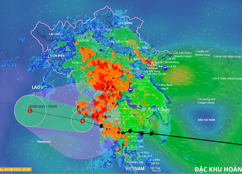
The National Center for Hydro-Meteorological Forecasting reported that at 4 a.m., the tropical depression had maximum sustained winds of 61 km/h (level 7), with gusts reaching level 9 in central Laos. In the coming hours, the tropical depression is expected to move west-northwest at a speed of 15-20 km/h and continue to weaken.
The meteorological agency recorded maximum wind gusts of level 10, reaching level 13 in Cam Nhuong (Thanh Hoa); level 15 gusts in Dien Chau (Nghe An) and level 12 gusts in Do Luong and Vinh; and level 8 gusts, reaching level 11 in Ky Anh (Ha Tinh).
Some areas further from the storm's center, such as Bach Long Vi (Hai Phong) experienced level 7 winds, gusting to level 9; Co To (Quang Ninh) had level 7 winds with gusts to level 10; and Hon Ngu (Nghe An) saw level 8 winds and level 11 gusts.
 |
Rain covers most of northern and north-central Vietnam. Photo: Disaster Monitoring System |
Rain covers most of northern and north-central Vietnam. Photo: Disaster Monitoring System
Storm surges were measured at 1.01 meters in Sam Son (Thanh Hoa), 1.66 meters in Hon Ngu (Nghe An), and 0.51 meters in Vung Ang (Ha Tinh).
The northern delta and the Thanh Hoa to Quang Tri region have received over 600 mm of rain. Rainfall from 7 p.m. on 25/8 to 3 a.m. today was recorded at 160 mm in Thuong Tin (Hanoi), 157 mm in Huong Nhuong 2 (Phu Tho), 211 mm in Son Kim 2 (Ha Tinh), 190 mm in Dong Van (Nghe An), and 171 mm in Xuan Khanh (Thanh Hoa).
Last night, Deputy Minister of Agriculture and Environment Nguyen Hoang Hiep assessed Kajiki as an unusual storm, forming directly over the East Sea and making landfall in just three days, half the usual time. The storm stalled, remaining almost stationary for two hours before landfall, creating the impression that it had dissipated.
The National Center for Hydro-Meteorological Forecasting predicts that this morning, the Gulf of Tonkin (including the special administrative-economic units of Bach Long Vi, Cat Hai, Co To, Van Don, and Hon Ngu Island) will continue to experience strong winds of level 6-7, gusting to level 8, with waves reaching 2-5 meters. Inland areas of Thanh Hoa, Nghe An, and the coastal region of Ninh Binh will also experience strong winds of level 6-7, gusting to level 9.
From now until the end of tomorrow, the midlands and northern delta, Lao Cai, Son La, and Thanh Hoa to Ha Tinh will continue to see 50-100 mm of rain, with localized areas receiving over 200 mm. There is a risk of high-intensity rainfall exceeding 100 mm in three hours.
Hanoi, Ho Chi Minh City, and Da Nang will also experience rain throughout today. Meanwhile, from now until tomorrow, upper and central Laos will receive 100-250 mm of rain, with some areas in central Laos receiving over 500 mm. This rain in Laos poses a risk of flooding and landslides in Vietnam, as some rivers in north-central Vietnam originate there.
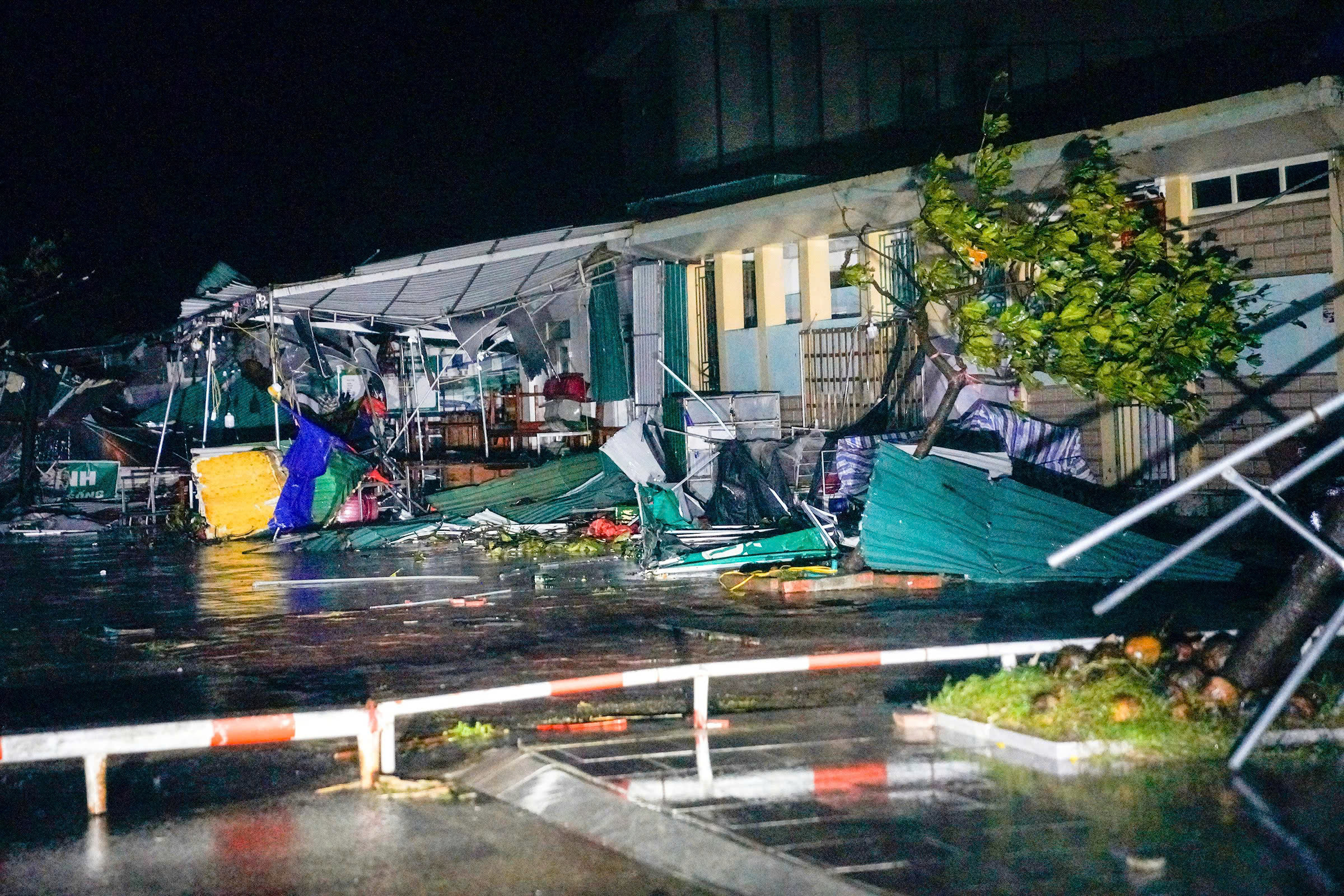 |
Coastal shops in Thien Cam lie in ruins at 7:30 p.m. on 25/8. Photo: Nguyen Dong |
Coastal shops in Thien Cam lie in ruins at 7:30 p.m. on 25/8. Photo: Nguyen Dong
Last night, the prime minister issued the third official dispatch regarding post-storm recovery and response. The dispatch requests ministers, party secretaries, and chairmen of provinces from Thanh Hoa to Quang Tri to direct local authorities to assess the specific situation in each area. They are tasked with deciding and developing plans to support residents in returning home from evacuation centers in areas deemed safe.
The dispatch also mandates the complete evacuation and relocation of residents in dangerous areas, especially those prone to deep flooding during heavy rains and areas at risk of flash floods, landslides, and providing essential needs for evacuees.
Localities are also required to deploy personnel at checkpoints to guide and assist people in safe travel. Leaders are assigned to directly oversee flood response efforts in key areas, particularly villages at risk of isolation due to floods and landslides. They must also review and implement contingency plans for electricity and telecommunications supply, ensuring uninterrupted communication from villages to higher levels.
The prime minister also requires localities to manage the safe operation of irrigation and hydropower reservoirs and dikes. They must proactively develop response plans to ensure the safety of residents in the worst-case scenario, avoiding passivity and surprise. Forces, vehicles, and equipment must be readily available in key, vulnerable areas for search and rescue operations in emergencies.
 |
High tide causes flooding on many streets in Cua Lo ward, Nghe An, on the afternoon of 25/8. Photo: Duc Hung |
High tide causes flooding on many streets in Cua Lo ward, Nghe An, on the afternoon of 25/8. Photo: Duc Hung
For households with damaged or destroyed roofs, the prime minister has requested temporary housing assistance. Repairs to schools and medical facilities should be completed by August 2025. Obstacles must be cleared, and roads cleaned to ensure a swift return to normal traffic flow after the storm.
The ministers of National Defense and Public Security are directed to instruct Military Region 4 and units stationed in the affected areas to deploy necessary forces, vehicles, and equipment to be ready to support the people in responding to and quickly overcoming the consequences of the storm and floods upon request from localities.
The minister of Science and Technology is directed to urge telecommunications service providers (VNPT, Viettel) to focus on immediately repairing damaged telecommunications systems and restoring service. The minister of Industry and Trade is directed to ensure the safety of hydropower reservoirs and immediately repair the power grid.
The ministries of Health, Construction, and Agriculture and Environment are instructed to carry out their respective duties to ensure public health, repair damaged roads, and closely monitor and provide timely warnings of further flood developments.
Gia Chinh


