The National Center for Hydro-Meteorological Forecasting reported that at 7 am on 10/7, the eye of typhoon Ba Vi was located approximately 650 km east-southeast of Taiwan (China) and about 1,000 km east-southeast of Fujian province (China).
The strongest winds reached 166 km/h, corresponding to level 14, with gusts up to level 16. Compared to yesterday, the typhoon has weakened by two levels and is no longer classified as a super typhoon. Over the next 24 hours, the typhoon is expected to continue moving northwest at a speed of about 25 km/h and tend to weaken further.
Forecasts indicate that over the next two to three days, Ba Vi will shift more northward, heading towards the coast between Fujian and Zhejiang provinces (China). The typhoon is likely to make landfall in mainland China on the night of 11/7 and early morning of 12/7, with winds of level 10-12 and gusts up to level 14. It is then expected to rapidly weaken as it moves deeper inland.
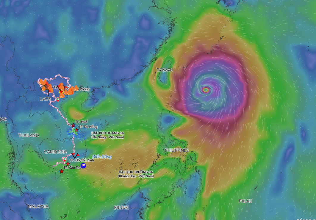 |
Location of typhoon Ba Vi on the morning of 10/7. *Photo: Disaster Monitoring System*
The Japan Meteorological Agency reported that the typhoon currently has winds of 162 km/h, which are expected to decrease to 144 km/h when it reaches northern Taiwan. The Hong Kong Observatory forecasts that the typhoon will maintain winds of 175 km/h, reducing to 140 km/h upon making landfall in mainland China.
According to the Vietnamese meteorological agency, Ba Vi will not enter the Bien Dong, but its broad circulation will still affect weather conditions at sea. Today, waters from Khanh Hoa to Vinh Long, as well as the central and southern Bien Dong, including the Truong Sa archipelago, will experience strong winds of level 6, gusting to level 7-8. The eastern North Bien Dong will also see winds gradually strengthen to level 6, gusting to level 8, with sea waves reaching two to four meters high.
The meteorological agency advises vessels operating in affected sea areas to closely monitor weather developments, proactively adjust their routes, and seek safe shelter when necessary.
Ba Vi is the third super typhoon to form in the Northwest Pacific region in 2026. The typhoon originated east of the Philippines, reaching a maximum intensity of level 16-17 before shifting northward towards Taiwan and southeastern China. All forecast models indicate that the typhoon will not enter the Bien Dong.
The National Center for Hydro-Meteorological Forecasting states that July to September marks the peak of the 2026 typhoon season. Although the number of typhoons in the Bien Dong is projected to be near the multi-year average, powerful typhoons in the Northwest Pacific can still cause strong winds, high waves, and rough seas in Vietnamese waters through their broad circulation, even if they do not directly enter the Bien Dong.
Gia Chinh