

On the evening of 24/8, Mai Van Khiem, director of the National Center for Hydro-Meteorological Forecasting, spoke to VnExpress about Typhoon Kajiki, which is approaching central Vietnam.
In Khiem's assessment, Kajiki is one of the most dangerous typhoons in recent years. On the afternoon of 23/8, it intensified to a category 11 storm, with gusts reaching category 13. It is projected to reach category 12-13, with gusts of 15-16, within the next 24 hours.
The typhoon has a wide circulation and is moving quickly over sea temperatures of up to 30 degrees Celsius. Fueled by the southwest monsoon, it has a high probability of further intensification.
 |
Mai Van Khiem discusses Typhoon Kajiki with VnExpress. Photo: Gia Chinh |
Mai Van Khiem discusses Typhoon Kajiki with VnExpress. Photo: Gia Chinh
Khiem emphasized the typhoon's potential for widespread impact. At sea, strong winds, high waves, and storm surges are expected. Inland areas face strong winds and exceptionally heavy rainfall, potentially exceeding 600 mm in some locations, leading to a very high risk of widespread flooding, flash floods, and landslides. The typhoon threatens not only coastal areas and the plains but also mountainous regions.
Khiem believes Kajiki's threat level is comparable to Typhoon Yagi in 2024 in terms of wind strength. It is at least equal to, if not stronger than, Typhoon Doksuri in 2017, which caused significant damage in Ha Tinh.
The National Center for Hydro-Meteorological Forecasting has issued a level 4 disaster risk warning, indicating a very high threat. Residents and local authorities are urged to prepare, evacuate as needed, and exercise extreme caution.
When asked about past storms similar to Kajiki, Khiem noted that while many have followed similar paths, Typhoon Doksuri in 2017 is the closest comparison in intensity, movement, and impact regarding heavy rain and strong winds.
Doksuri also formed in the East Sea, moving swiftly at an average speed of 20 km/h and strengthening as it approached the coast. It had a radius of strong winds (category 6 and above) of approximately 250 km. The storm was intense and fully developed, symmetrical from low to high altitudes. At sea, it peaked at category 13, with gusts of 15, and made landfall at category 11-12, with gusts of 14.
In 2017, Doksuri impacted the coastal provinces from Ha Tinh to northern Quang Tri (formerly Quang Binh province), bringing winds of category 11-12 and gusts of 14-15. It caused heavy rainfall across the provinces from Thanh Hoa to Quang Ngai, generally between 100-200 mm, with 200-300 mm in Ha Tinh and Quang Tri. Some areas experienced even higher rainfall: Tuyen Hoa (Quang Binh) 383 mm, Dong Hoi (Quang Binh) 347 mm, Cuu Viet (Quang Tri) 361 mm, and Ha Tinh City 336 mm. Southern areas of the northern delta, Hoa Binh, and Son La also received 50-150 mm of rain.
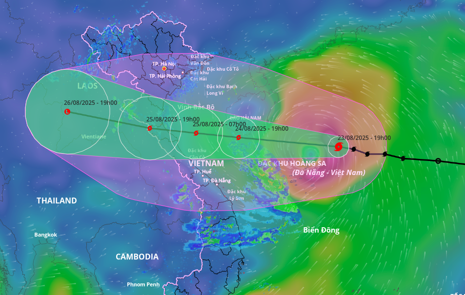 |
Projected path and area of influence for Typhoon Kajiki, evening of 24/8. Image: Disaster Monitoring System |
Projected path and area of influence for Typhoon Kajiki, evening of 24/8. Image: Disaster Monitoring System
Khiem's greatest concern is Kajiki's potential to trigger multiple hazards. At sea, winds could reach category 12-13 with gusts of 15-16, waves could reach 6-8 meters, and storm surges could add 0.5-1.2 meters to sea levels. This poses a significant danger to ships, fishing cages, aquaculture farms, and coastal embankments, including those in northern coastal provinces.
Starting tomorrow night, inland provinces from Thanh Hoa to Quang Tri can expect winds of category 7-9, with areas near the typhoon's center experiencing category 10-12 winds and gusts of 14-15. Winds of this strength could cause roof damage.
With limited preparation time, Khiem urged local authorities to quickly identify and evacuate people in vulnerable areas, such as low-lying regions, coastal areas, riverbanks, and landslide-prone areas. They should also suspend ship traffic, secure fishing cages and aquaculture farms, and halt all marine activities within the danger zone.
Local authorities should also inspect and reinforce critical infrastructure, such as dikes, embankments, and reservoirs, as a precaution.
Residents are advised to secure their homes, stock up on essential supplies, and move to safe locations as directed by authorities. Those in the coastal provinces of Ha Tinh and Quang Tri, directly in Kajiki's path, should avoid going outside during heavy rain and strong winds.
Staying informed through regular weather forecasts and warnings is crucial for timely action and safety. Khiem cautioned that the risk of flash floods and landslides will persist even after the typhoon passes.
Gia Chinh


