

Typhoon Ragasa originated on 18/9 as a tropical depression off the Philippines. Three days later, it intensified by eight categories to become a super typhoon. By the evening of 22/9, it entered the South China Sea, reaching a peak intensity of category 17 with winds of 221 km/h. Ragasa surpassed Typhoon Yagi (2024) as the strongest typhoon in the South China Sea in 70 years.
Dr. Truong Ba Kien, Deputy Director of the Center for Meteorological and Climate Research, Institute of Meteorology, Hydrology and Climate Change, highlighted several reasons for the typhoon's rapid intensification. First, the typhoon formed in the Western Pacific Ocean, moving west-northwest between the Philippines and Taiwan, over open waters without interacting with land or islands.
"The sea surface temperature in this area was a stable 29-30°C. The deep, warm water provided ample energy for the typhoon's development," Kien said.
 |
Dr. Truong Ba Kien analyzes Super Typhoon Ragasa. Photo: Gia Chinh |
Dr. Truong Ba Kien analyzes Super Typhoon Ragasa. Photo: Gia Chinh
Second, factors such as low vertical wind shear (a sudden change in wind speed or direction over a short distance) allowed for symmetrical circulation. Low-level convergence combined with significant upper-level divergence created efficient ventilation, preventing the system from becoming choked, thus strengthening the typhoon.
Regarding dynamics, Kien analyzed that the typhoon was situated within a region of large-scale cyclonic rotation and a strong converging current, accelerating convection and momentum concentration within the typhoon's core. Simultaneously, the typhoon's center was located on the southwestern edge of the subtropical high-pressure zone, creating a stable steering flow that allowed the typhoon to develop continuously without deviating or dispersing its energy.
The expert stated that during its intensification, Ragasa underwent an eyewall replacement cycle—a phenomenon where the thick cloud layer surrounding the center is replaced by a new eyewall. This resulted in a large, round eye with smaller vortices inside, further concentrating wind energy and intensifying maximum wind speeds.
"Thanks to the favorable thermodynamic and dynamic conditions mentioned above, Ragasa reached its peak intensity of category 17 precisely during its mature stage, when the typhoon's structure was most fully developed, symmetrical, and stable," Kien explained.
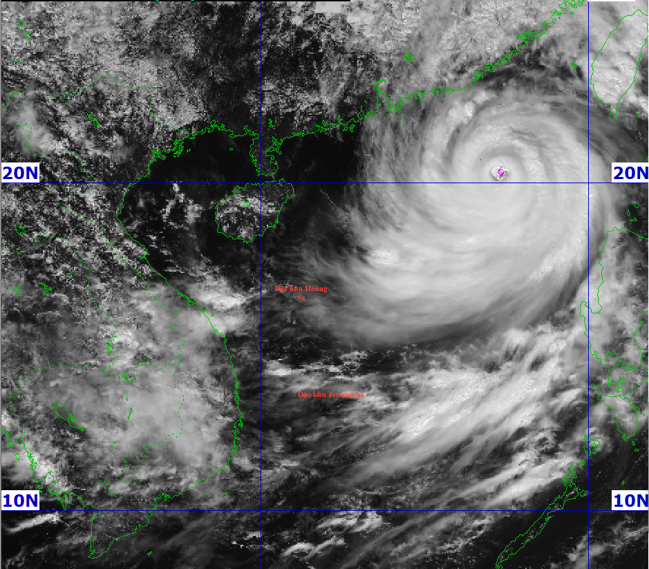 |
Satellite image of Super Typhoon Ragasa at 10 a.m. on 23/9. Photo: NCHMF |
Satellite image of Super Typhoon Ragasa at 10 a.m. on 23/9. Photo: NCHMF
After reaching peak intensity on the evening of 22/9, Ragasa maintained its strength until it began showing signs of weakening by midday 23/9. At 10 a.m., the super typhoon was in the northern South China Sea with winds of 184-221 km/h, category 16-17, gusting above category 17, and moving west-northwest at 20 km/h. This weakening began earlier than predicted by the Vietnam Meteorological Agency.
Mai Van Khiem, Director of the National Center for Hydro-Meteorological Forecasting, identified several factors contributing to Ragasa's rapid weakening, primarily two major causes. First, a continental high-pressure system with dry air and 30-40% humidity persisted to the north, moving southward.
"The entire northern part of the typhoon will be affected by this dry air. Dry swirls will penetrate the typhoon's structure, weakening it as it approaches the waters south of Guangdong province and Leizhou Island on 24/9," Khiem stated.
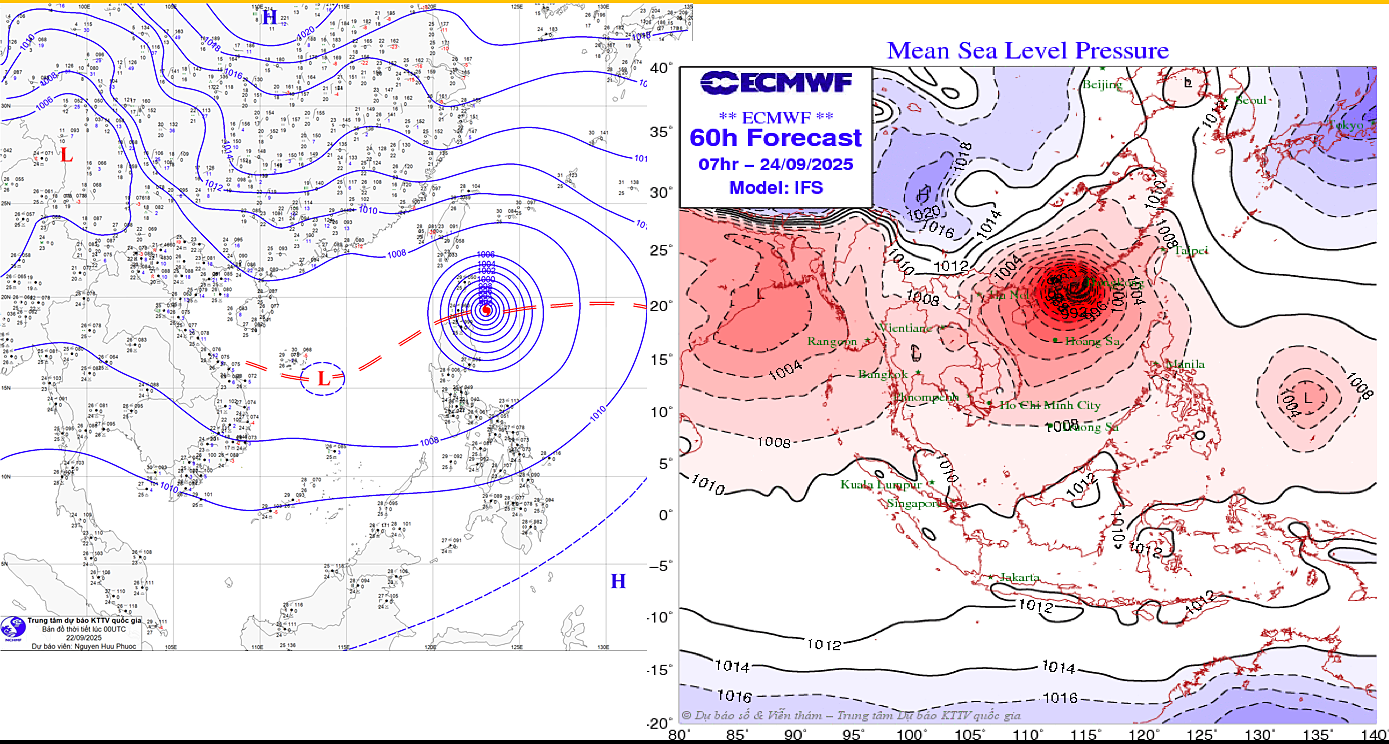 |
The continental high-pressure system (blue) encroaches on Super Typhoon Ragasa. Photo: NCHMF |
The continental high-pressure system (blue) encroaches on Super Typhoon Ragasa. Photo: NCHMF
Second, in the next two to three days, Ragasa will track further north, increasing its interaction with the terrain of mainland China. The Vietnam Meteorological Agency collaborated with Japan on an AI-powered forecasting experiment, incorporating international forecasts. "Currently, all stations agree that the typhoon will move towards the north of Leizhou Island, unlike Yagi, which tracked further south, experiencing less impact from terrain friction," Khiem explained.
Additionally, Khiem noted that the typical lifecycle of a typhoon is about 5 to 7 days, with peak intensity occurring on days three or four. Since Ragasa formed on 18/9, it is currently in its most developed stage and is expected to weaken afterward.
Dr. Truong Ba Kien further explained that as the typhoon approaches the Chinese coast, it will encounter less favorable conditions such as decreasing sea surface temperatures, reduced atmospheric heat and moisture content, increased wind shear, and interaction with dry air from the north and the Chinese coastal terrain, causing the typhoon's structure to become asymmetrical and its intensity to decrease.
However, Kien cautioned that if, after crossing the Leizhou Peninsula, the typhoon shifts southward towards the Gulf of Tonkin, where the sea is warmer with better moisture convergence, its circulation could reorganize and strengthen by one or two categories.
Gia Chinh


