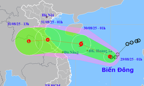
One day after entering the South China Sea, Ragasa has weakened, now a category 15-16 storm. It is expected to make landfall between Quang Ninh and Hai Phong around noon on 25/9 with winds of 8-9.
Ragasa intensified rapidly due to its formation in open waters with sea surface temperatures of 29-30°C. Its rapid weakening is attributed to encountering dry air from the north and friction with land.
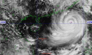
At 10 p.m. on 22/9, super typhoon Ragasa entered the South China Sea with maximum sustained winds of 221 km/h, reaching category 17 and gusts exceeding category 17. This marks the 9th storm to form in the region this year.
On the afternoon of 21/9, typhoon Ragasa, located east of Luzon Island (Philippines), intensified by three categories from this morning to a category 16 super typhoon, with gusts exceeding category 17.
This evening, Typhoon Mitag will make landfall in southern China with winds of level 8-9. The remnants of the typhoon are forecast to bring rain to northern Vietnam on September 23-24.
A tropical depression is forecast to enter the South China Sea tonight, with the potential to strengthen into a typhoon and head towards mainland China, posing no direct threat to Vietnam.
A tropical depression is forecast to intensify into a typhoon and enter the South China Sea, while another low-pressure area persists in the central South China Sea.
The tropical depression in the northeastern South China Sea has intensified, and is expected to become a typhoon Tuesday, potentially reaching a severity of category 9 (88 km/h).
A tropical depression formed in the northeastern South China Sea on the evening of 5/9 and is forecast to strengthen into Typhoon No. 7 tomorrow, bringing strong winds and high waves.
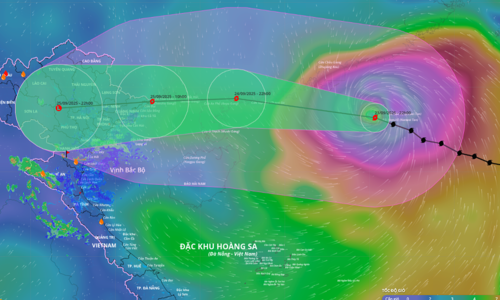
A tropical depression is expected to intensify into a typhoon near the Paracel Islands, but its strength is predicted to remain at level 8, with gusts up to level 10.