The National Center for Hydro-Meteorological Forecasting reported this morning that Tapah is located in the northern area of the South China Sea, with maximum sustained winds of 88 km/h (category 8-9), and gusts reaching category 11. The typhoon is moving west-northwest at 10 km/h.
By 4 a.m. tomorrow, Tapah is projected to be south of Guangdong province, China, with winds reaching category 10 and gusts of 13. The typhoon is then expected to turn northwest and make landfall in China, moving at 10-15 km/h.
The Japan Meteorological Agency today predicted Tapah will peak at 90 km/h before reaching Guangdong. It will then track towards Vietnam's mountainous provinces and weaken. The Hong Kong Observatory suggests the typhoon could strengthen to 110 km/h. The resulting low-pressure system may bring rain to Quang Ninh, Lang Son, Cao Bang, Thai Nguyen, Tuyen Quang, and Lao Cai provinces.
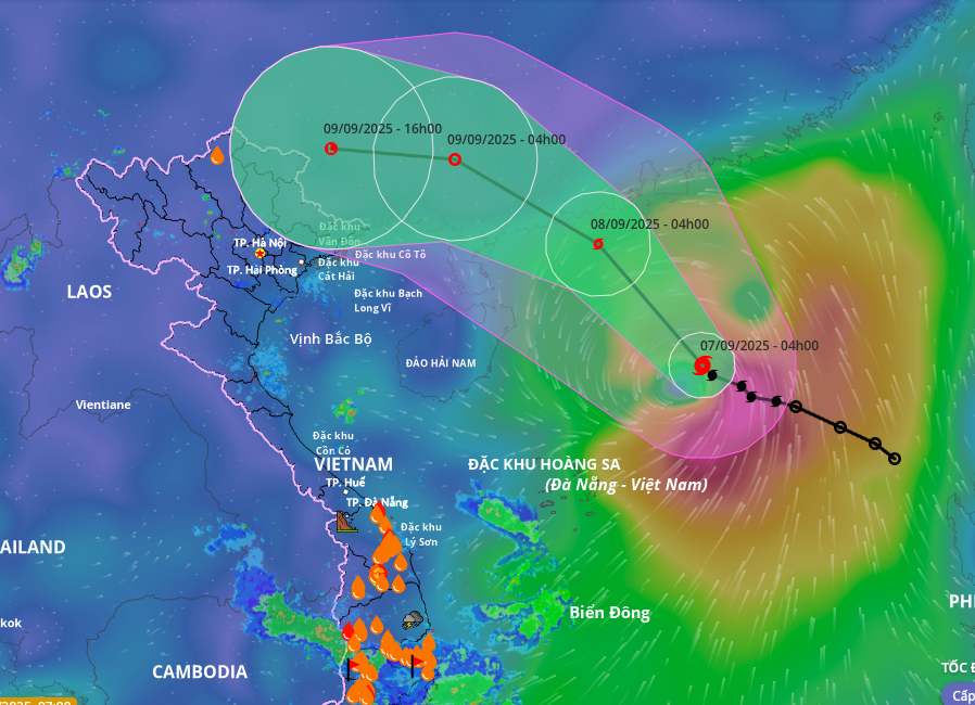 |
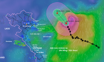
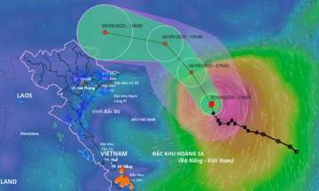
Projected path and area of influence of Typhoon Tapah. Image: Disaster Monitoring System |
Projected path and area of influence of Typhoon Tapah. Image: Disaster Monitoring System
According to Vietnam's meteorological agency, Tapah formed on the Intertropical Convergence Zone in a relatively high latitude in the northern part of the South China Sea, and its trajectory is veering north.
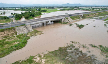
After making landfall in China, Tapah is forecast to rapidly weaken into a low-pressure area and drift westward toward Vietnam. From the afternoon and evening of September 9 to 11, the remnants of the typhoon are likely to cause widespread heavy rain in northern Vietnam, particularly in the midlands and mountainous areas of the northeast.
Due to Tapah's influence, the northern South China Sea is experiencing winds of category 7-8, increasing to category 9-10 near the typhoon's center, with gusts up to category 13. Waves are expected to reach 3-5 meters. Vessels operating in these areas are at risk.
Yesterday, the Ministry of Agriculture and Rural Development issued an urgent dispatch to coastal provinces from Quang Ninh to Dak Lak, urging them to closely monitor Tapah’s progress. They were instructed to notify vessels of the typhoon’s location, trajectory, and danger zones so they can navigate around it. They were also instructed to prepare search and rescue teams for any emergencies.
Seven typhoons have formed in the South China Sea this year. Typhoon Nongfa, the sixth typhoon, recently made landfall in Ha Tinh and northern Quang Tri with low intensity and minimal damage. Typhoon Kajiki, the fifth typhoon, hit Thanh Hoa and Ha Tinh on 25/8, resulting in 9 deaths and missing persons, injuries to 77 people, damage to over 38,600 houses (with 510 completely destroyed), and total economic losses of approximately 2,900 billion VND.
The National Center for Hydro-Meteorological Forecasting predicts that 5 to 7 more typhoons or tropical depressions will form in the South China Sea before the end of the year. Of these, 2 to 3 are expected to directly impact mainland Vietnam, primarily from the central region southward. With cold air expected to arrive early, flooding and heavy rain could be severe later this year.
Gia Chinh