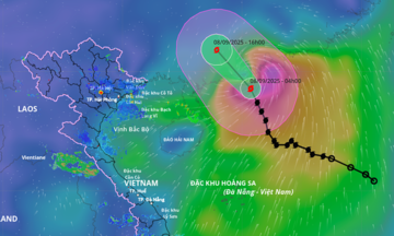
According to the National Center for Hydro-Meteorological Forecasting, at 7 p.m. on 7/9, Typhoon Tapah was located in the northern area of the South China Sea with maximum sustained winds of 102 km/h (level 9-10), with gusts reaching level 13. The typhoon was moving north-northwest at 15-20 km/h.
By 7 a.m. on 8/9, the typhoon is predicted to be near the southern coast of Guangdong, with winds reaching level 10 and gusts up to level 13. It is then expected to make landfall and weaken into a tropical depression. By that evening, the depression is forecast to be south of Guangdong, with maximum sustained winds of level 6 and gusts two levels higher.
Both the Japan Meteorological Agency and the Hong Kong Observatory also reported the typhoon had reached its peak intensity, with winds of 85-90 km/h. After passing over Guangdong, the typhoon is expected to move westwards towards the mountainous regions of northern Vietnam.
Vietnamese meteorological authorities predict widespread rain across northern Vietnam starting on the afternoon and evening of 9/9. Mountainous and midland regions are likely to experience heavy rain, with totals between 70 and 150 mm, and exceeding 300 mm in some areas. Some regions could see intense rainfall, exceeding 100 mm in three hours.
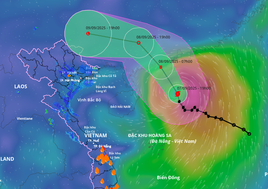 |
Projected path and area of influence of Typhoon Tapah. Image: Disaster Monitoring System |
Projected path and area of influence of Typhoon Tapah. Image: Disaster Monitoring System
In the South China Sea, the northern area can expect strong winds of level 7-8, increasing to level 9-10 near the typhoon's center, with gusts up to level 13, and waves 4-6 meters high. Vessels operating in these dangerous areas are advised to limit their activities. The outer bands of the typhoon could also cause thunderstorms, tornadoes, and strong gusts in the Gulf of Tonkin and along the northeastern coast.
From 11/9, as the tropical depression dissipates, the rain in northern Vietnam is expected to decrease. From 12/9 to 14/9, the weather is predicted to be dry and cool.
The Ministry of Agriculture and Rural Development has directed provinces in the mountainous and midland regions of northern Vietnam to closely monitor weather reports and warnings of heavy rain, flash floods, and landslides. They have also been instructed to check high-risk areas and proactively evacuate residents. Authorities will be stationed to prevent people and vehicles from crossing flooded areas or underpasses when it is unsafe. Key infrastructure will also be inspected to ensure the safety of dikes and drainage systems, and rescue plans will be prepared.
Seven typhoons have formed in the South China Sea since the beginning of the year. Most recently, Typhoon Nongfa, the 6th typhoon of the year, made landfall in Ha Tinh and northern Quang Tri with low intensity, causing minimal damage. Earlier, Typhoon Kajiki, the 5th typhoon, hit Thanh Hoa and Ha Tinh on 25/8, resulting in 9 deaths and missing persons, injuries to 77 people, damage to over 38,600 houses (with 510 collapsing), and total economic losses of about 2,900 billion VND.
The National Center for Hydro-Meteorological Forecasting predicts 5-7 more typhoons or tropical depressions in the South China Sea before the end of the year, with 2-3 directly affecting the mainland, primarily from central to southern Vietnam. Early cold fronts are expected, which could lead to complex flooding patterns later in the year.
Gia Chinh