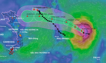
The National Center for Hydro-Meteorological Forecasting reported that this morning, the typhoon was located approximately 600 km east of Luzon Island (Philippines), with maximum sustained winds of 149 km/h (category 13), gusts reaching category 16. It is currently moving northwest at a speed of 10-15 km/h.
Tomorrow morning, the typhoon is predicted to be 240 km from Luzon Island, with maximum sustained winds of category 14-15 and gusts exceeding category 17. It will shift its course to the west-northwest, maintaining a speed of 15 km/h and continuing to strengthen.
By 1 a.m. on 23/9, the typhoon will be north of Luzon Island, with maximum sustained winds reaching category 16 and gusts exceeding category 17, maintaining its course and increasing its speed to 15-20 km/h. Ragasa will then enter the South China Sea and by 1 a.m. on 24/9, it will be approximately 140 km southeast of Hong Kong.
 |
Projected path and affected area of Typhoon Ragasa on 21/9. Photo: NCHMF |
Projected path and affected area of Typhoon Ragasa on 21/9. Photo: NCHMF
Meteorological agencies predict that on 25/9, the typhoon will pass over the Leizhou Peninsula (China) with winds at category 15, weakening to category 12 as it enters the Gulf of Tonkin.
The Japan Meteorological Agency assesses that Super Typhoon Ragasa will be at its strongest after crossing Luzon and entering the South China Sea, with winds reaching 198 km/h. The typhoon will then approach the Chinese coast before entering the Gulf of Tonkin, with winds decreasing to 108 km/h.
The Hong Kong Observatory concurs with the projected path but estimates the maximum intensity on 23/9 could reach 220 km/h. Upon reaching the Leizhou Peninsula, the typhoon is expected to maintain winds of 145 km/h.
Due to the typhoon's influence, from the afternoon of 22/9, the eastern area of the northeastern part of the South China Sea will experience strong winds of categories 6-7, later increasing to categories 8-9, with gusts reaching category 11. From the night of 22/9, wind speeds will further escalate to categories 10-13, and in areas near the typhoon's center, to categories 14-16, with gusts exceeding category 17. Wave heights will range from 4-8 meters, exceeding 10 meters near the typhoon's center. Vessels operating in this area are likely to be impacted.
The National Steering Committee for Natural Disaster Prevention and Control has instructed provinces from Quang Ninh to Lam Dong to closely monitor the typhoon's progress, issue warnings to vessels, and prepare rescue forces.
Since the beginning of the year, the South China Sea has experienced eight typhoons and two tropical depressions. Yesterday, Typhoon Mitag made landfall in China, posing no direct threat to Vietnam. Typhoon Tapah, while not directly impacting Vietnam, brought heavy rain and landslides to several northern mountainous provinces. Typhoon Nongfa hit central Vietnam at the end of August with category 8 winds, isolating many mountainous areas in Ha Tinh, Quang Tri, and Nghe An provinces.
The western North Pacific in 2024 recorded three super typhoons (maximum sustained winds of 201 km/h or higher, category 16): Yagi, Gaemi, and Krathon. Super Typhoon Yagi, which made landfall in Vietnam, caused widespread damage, including strong winds, landslides, flash floods, and inundation. Yagi resulted in 318 deaths and 26 missing persons, inflicting nearly 84,000 billion VND in economic damage to Vietnam.
From October to December, the number of typhoons and tropical depressions is forecast to be higher than the multi-year average (typically over 4 storms, with nearly 2 making landfall).
Gia Chinh