At 4 a.m., the typhoon's center was located approximately 87 miles from Quang Ninh province, 43 miles from Hai Phong city, 50 miles from Hung Yen province, and 62 miles from Ninh Binh province, according to the National Center for Hydro-Meteorological Forecasting. The typhoon packed sustained winds of 74-118 mph with gusts up to 132 mph. It was moving west-southwest at 9 mph.
The typhoon is projected to make landfall in Hung Yen province this morning, then move into Ninh Binh. As it moves inland, the typhoon is expected to weaken to 60-73 mph with gusts up to 96 mph over Hai Phong and Thanh Hoa by 4 p.m. It will then further dissipate over the Vietnam-Laos border region.
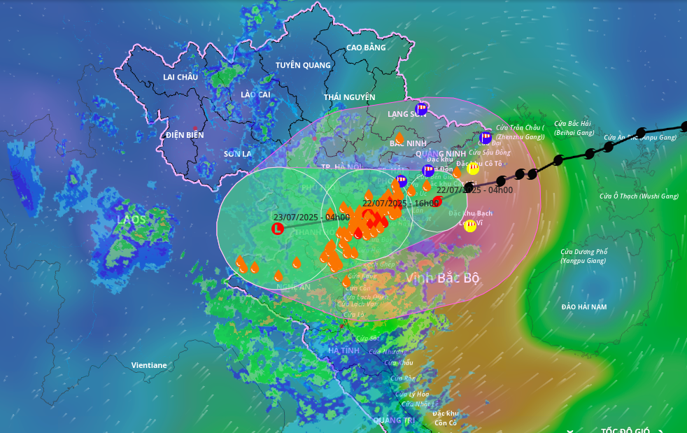 |
Projected path and affected area of Typhoon Wipha, morning of 22/7. Image: Disaster Monitoring System |
Projected path and affected area of Typhoon Wipha, morning of 22/7. Image: Disaster Monitoring System
The Japan Meteorological Agency predicts the typhoon will cross Hung Yen (formerly Thai Binh) and Ninh Binh (formerly Nam Dinh) with maximum sustained winds of 67 mph. The Hong Kong Observatory forecasts a similar path but estimates the typhoon's intensity at 56 mph.
Wind speeds of 74-118 mph with gusts up to 132 mph have been recorded in Bach Long Vi island. Co To island experienced winds of 60-73 mph with gusts up to 118 mph, while Cat Ba island (Cat Hai district) experienced winds of 39-46 mph with gusts up to 60 mph. Cua Ong recorded winds of 74-85 mph with gusts up to 132 mph, Bai Chay 60-73 mph with gusts up to 74 mph, Quang Ha 60-73 mph, Tien Yen 47-60 mph with gusts up to 74 mph, Thai Binh station 47-60 mph with gusts up to 60 mph, and Phu Lien 39-46 mph with gusts up to 60 mph.
The northern Gulf of Tonkin, including Bach Long Vi, Co To, Van Don, Cat Hai, and Hon Dau islands, is experiencing winds of 47-60 mph, increasing to 74-118 mph with gusts up to 132 mph near the typhoon's center. Wave heights are 6-13 feet, reaching 10-16 feet near the eye of the storm.
The southern Gulf of Tonkin (including Hon Ngu island) is experiencing winds of 39-46 mph, increasing to 60-73 mph with gusts up to 118 mph near the typhoon's center. Wave heights are 6-13 feet.
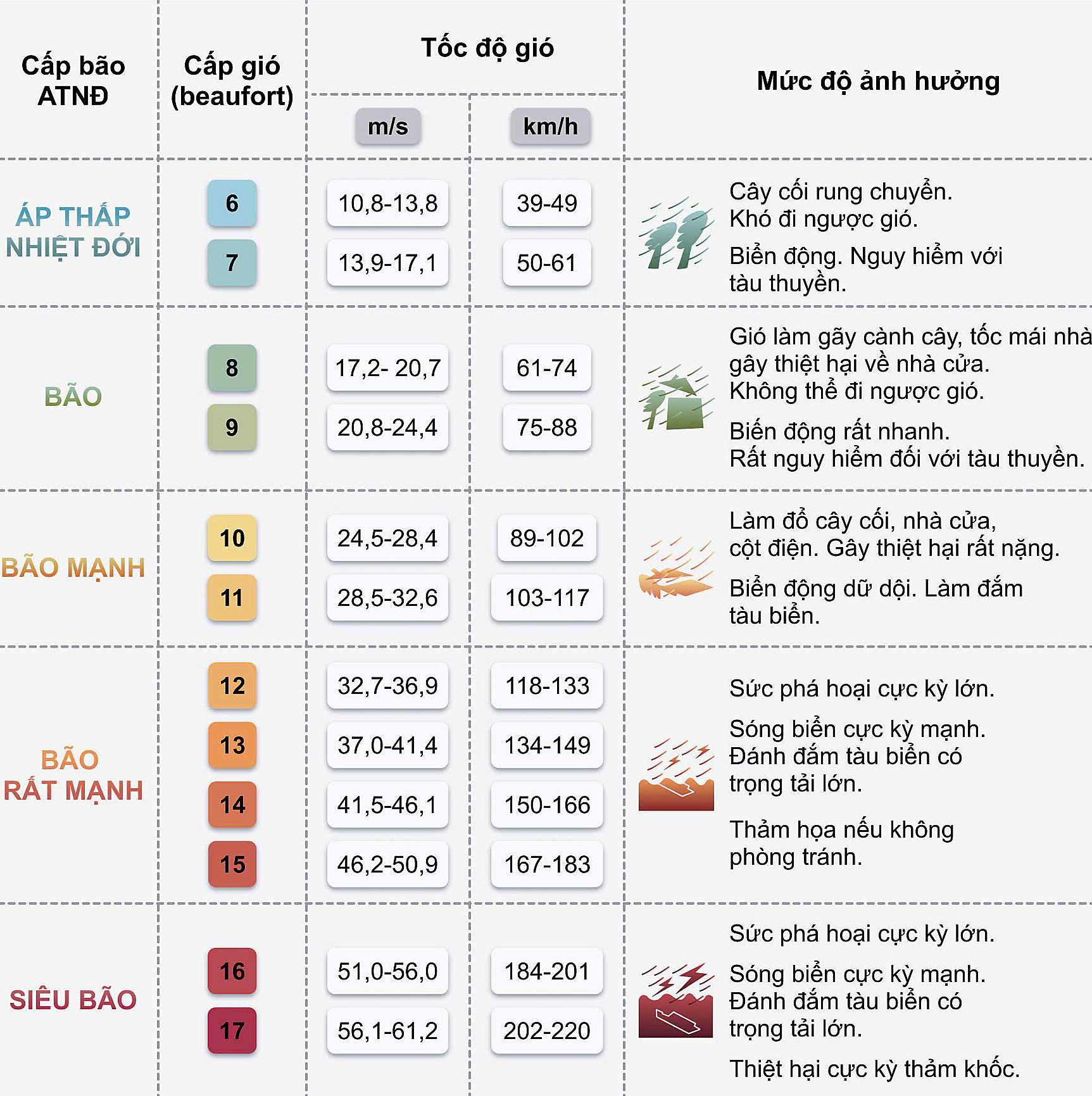 |
Wind speeds and corresponding impact warnings. Graphic: Minh Thu |
Wind speeds and corresponding impact warnings. Graphic: Minh Thu
Coastal areas from Quang Ninh to Nghe An provinces are experiencing winds of 47-60 mph, increasing to 74-118 mph with gusts up to 132 mph near the typhoon's center. Inland areas of Hai Phong, Hung Yen, Bac Ninh, Hanoi, Ninh Binh, and Thanh Hoa are experiencing winds of 39-46 mph with gusts up to 60 mph. Winds of 74-118 mph can uproot trees, down power lines, and tear off roofs, causing significant damage.
Storm surge of 1.5-3 feet is expected along the coast from Hung Yen to Quang Ninh. Water levels are predicted to reach 8-8.5 feet in Ba Lat (Hung Yen), 13-13.5 feet in Hon Dau (Hai Phong), 15-16.5 feet in Cua Ong (Quang Ninh), and 12-13 feet in Tra Co (Quang Ninh). There is a high risk of flooding in coastal areas and river estuaries this afternoon.
From this morning until 23/7, the northern delta, Thanh Hoa, and Nghe An will experience widespread rainfall of 8-12 inches, with some areas receiving over 20 inches. Other areas in northern Vietnam and Ha Tinh will receive 3-6 inches of rain, with some areas receiving over 10 inches. There is a risk of intense rainfall exceeding 6 inches in 3 hours.
Gia Chinh