The National Center for Hydro-Meteorological Forecasting reported that Typhoon Wipha entered the northern Gulf of Tonkin on 21/7. At 10 a.m., the typhoon's center was located approximately 190 km east of Quang Ninh, 310 km east of Hai Phong, 340 km east-northeast of Hung Yen, and 360 km east-northeast of Ninh Binh. Maximum sustained winds near the typhoon's center reached level 9, with gusts up to level 11.
Throughout today, the typhoon is expected to intensify to levels 10-11, with gusts reaching level 14 as it moves into the waters off Hai Phong and Thanh Hoa, maintaining this intensity in the area.
Nguyen Thanh Binh from the Remote Sensing and Numerical Weather Forecast Department of the National Center for Hydro-Meteorological Forecasting, said the typhoon made landfall in southern China yesterday evening and slowed down upon entering the Gulf of Tonkin this morning. However, in recent hours, it has accelerated again to approximately 15 km/h, moving west-northwest.
"Currently, the typhoon's clouds cover the entire northeast region, but the convective clouds causing rain remain within a narrow range, so Hanoi and the northern delta haven't experienced much rain yet," Binh stated.
As the typhoon approaches the coast, the cloud organization will stabilize, and the convective cloud area will move inland, increasing rainfall rapidly. The heaviest rain is forecast from tonight to tomorrow morning as the typhoon nears the shore. Additionally, as the typhoon clouds encounter the northeast arc, rainfall will intensify in the mountainous regions of northern and north-central Vietnam, especially the western slopes of the Truong Son mountain range.
 |
Police, militia, and youth union members assist fishermen in moving their boats ashore along Ho Xuan Huong Road (Thanh Hoa). Photo: Le Hoang |
Police, militia, and youth union members assist fishermen in moving their boats ashore along Ho Xuan Huong Road (Thanh Hoa). Photo: Le Hoang
From 21/7 to 23/7, the northeast, northern delta, Thanh Hoa, and Nghe An are expected to receive 200-350 mm of rainfall, with some areas exceeding 600 mm. Other areas in northern Vietnam and Ha Tinh will see 100-200 mm, with some areas exceeding 300 mm. There is a high risk of extreme rainfall exceeding 150 mm in three hours.
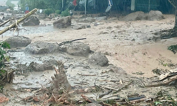
"Heavy rain can easily cause flooding in low-lying areas, landslides, and flash floods in mountainous regions. Landslides can occur even after the typhoon weakens, as the soil and rocks become saturated," Binh warned. She also noted that after the typhoon moves into Laos, northern and north-central Vietnam will continue to experience rainfall due to the influence of the intertropical convergence zone.
Furthermore, the heavy rain will cause rivers in northern Vietnam, Thanh Hoa, and Nghe An to experience a flood surge of 3-6 m from tonight to 25/7. Small rivers, the Thao River, and the upper reaches of the Ma River may reach warning levels two and three. The Lo, Da, Cau, Thuong, Luc Nam, Hoang Long rivers, and the upper reaches of the Ca River are forecast to reach warning levels one and two, with some areas exceeding warning level two. The lower reaches of the Red River and Thai Binh River will remain below warning level one; the lower reaches of the Ma and Ca rivers will fluctuate around warning level one.
Gia Chinh