At 4 p.m. on 20/7, the typhoon's center was located approximately 500 km east of Quang Ninh - Hai Phong, with maximum sustained winds reaching level 12 (133 km/h) and gusts up to level 15. The typhoon is moving westward at a speed of 20-25 km/h. The National Center for Hydro-Meteorological Forecasting predicts that on the afternoon of 21/7, the typhoon will enter the Gulf of Tonkin with an intensity of level 10-11 and gusts of level 14. On 22/7, it is expected to make landfall in the northern provinces, reaching as far south as Nghe An.
The typhoon will bring widespread heavy rain to northern Vietnam, from Thanh Hoa to Ha Tinh, starting 21/7. The northeast, the northern delta, Thanh Hoa, and Nghe An will experience continuous rain for three days, from 21/7 to 23/7, with rainfall totals between 200 and 350 mm, and exceeding 600 mm in some areas. Other regions can expect 100-200 mm of rain. Flooding is expected in many rivers, with water levels rising 3-6 m. Peak flood levels on the Thao River could reach warning level two or three; the Lo, Cau, Thuong, and Luc Nam rivers are predicted to reach warning level one, two, and above warning level two.
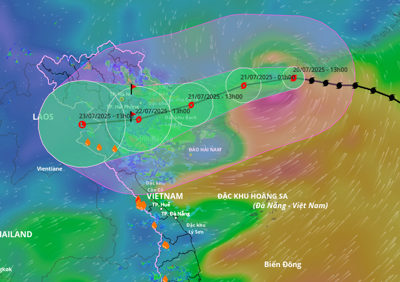 |
Projected path and area of influence of Typhoon Wipha, afternoon of 20/7. Photo: *Disaster Monitoring System* |
In an online meeting with 1,700 communes and wards on the morning of 20/7, Deputy Prime Minister Tran Hong Ha instructed relevant agencies to accurately assess the scale, intensity, and affected areas of the typhoon. Local authorities were directed to review their disaster response capabilities following recent administrative mergers, ensuring unified civil defense leadership and effective coordination among forces.
Coastal localities have informed, accounted for, and guided 54,300 vessels with over 227,000 workers to take proactive measures to avoid the typhoon. The total area of aquaculture at risk from Quang Ninh to Nghe An is nearly 149,000 ha, including over 20,000 cages and 3,700 watchtowers.
Ninh Binh province plans to implement a sea ban starting at 7 a.m. on 21/7, evacuating residents from vulnerable dike areas before noon the same day, while also draining inland fields to protect agricultural production. The provincial Military Command has deployed 100% of its personnel and suspended all leave from the morning of 21/7, ensuring readiness for the typhoon's landfall. Following recent mergers, the province now includes several key areas like Hai Thinh commune, Con Tron, the Hoang Long River region, and the southwestern part of the province.
Hung Yen province initiated a sea ban at 6 p.m. on 20/7. The province has 1,132 vessels with over 3,200 workers, most of which have been safely moored. The province also has over 1,100 aquaculture ponds and nearly 1,200 watchtowers with over 2,800 workers along the coast. Authorities have contacted all vessels and implemented evacuation plans for residents, especially workers on watchtowers and boats, to be completed before 5 p.m. on 21/7. The mooring of all vessels must be completed by 10 a.m. on the same day.
Hung Yen province has also instructed irrigation companies to fully open drainage gates to protect rice paddies, crops, residential areas, and industrial zones. They are also ensuring clear waterways, operating pumping stations, and preparing rescue forces and evacuation plans as needed.
Gia Chinh