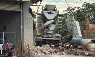
The deluge began around 5:30 h, quickly overwhelming drainage systems. In Cam Pha ward, floodwaters reached one meter, spilling into residential homes. Many vehicles stalled, forcing drivers to abandon them mid-street.
 |
Heavy rain from 5:30 h in the morning caused water to rise and flood homes in Cam Pha ward. *Photo: Pham Hung*
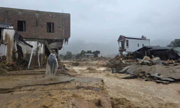
Areas like Hoanh Bo and Mong Duong also saw homes deluged with water, accompanied by mud and rocks. The flooding coincided with peak commuter hours, disrupting traffic as residents headed to work and students to school. The rain eased around 8:30 h, and water began to recede from the streets.
 |
Many oto stalled on To Hieu street, Cam Pha ward, on 19/5. *Photo: Pham Hung*
This recent event follows earlier heavy rainfall on 17-18/5, which caused prolonged flooding in Ha Long, Mong Cai, and Dam Ha. Rivers such as Ka Long, Ha Coi, and Tai Chi swelled, cutting off several inter-commune roads.
 |
Rainwater accompanied by soil and rocks flooded homes in Quang Ninh, on 19/5. *Photo: Pham Hung*
The National Center for Hydro-Meteorological Forecasting attributes the heavy rainfall from the night of 19/5 to the night of 20/5 to a moist southeast wind interacting with a wind convergence zone originating from Upper Laos at 5,000 m. This weather pattern is expected to bring moderate to heavy rain and thunderstorms across Northern Vietnam, Thanh Hoa, and Nghe An. Rainfall is generally predicted to be 40-80 mm, with some localized areas potentially receiving over 250 mm.
Rain is forecast to continue on 21/5, though with reduced intensity, typically ranging from 20-40 mm, but still reaching over 150 mm in isolated spots. The meteorological agency has issued warnings for potential flooding in low-lying areas, flash floods, and landslides in mountainous regions.
Le Tan