The National Center for Hydro-Meteorological Forecasting reported that at 4h today, storm Koto's eye was about 310 km northwest of Song Tu Tay island. It sustained maximum winds of 102 km/h, reaching categories 9-10, with gusts up to category 13, and was moving northwest at 5-10 km/h.
The storm's influence is bringing strong winds of categories 7-10, with gusts of categories 12-13, to the northwestern part of the central South China Sea, generating waves 3-8 m high. Offshore areas from Gia Lai to Khanh Hoa are experiencing winds of categories 6-8, with gusts of categories 9-10, and waves 4-6 m high. All vessels operating in these hazardous areas are likely to be affected.
Prime Minister Pham Minh Chinh signed a dispatch urging ministries, sectors, and provincial authorities to proactively respond at the highest level. The directive emphasizes closely monitoring developments and taking early, far-reaching actions to ensure public safety and minimize damage. Ministers and provincial People's Committee chairpersons are accountable to the Government for the effectiveness of these response efforts.
According to the Border Guard Command, provinces and cities from Da Nang to Ca Mau have informed, accounted for, and guided 50,732 vessels with 281,689 people about storm Koto's developments to ensure proactive prevention. Currently, no vessels are in the dangerous zone. Localities from Da Nang to Dak Lak have lowered reservoir water levels, creating flood control capacity for downstream areas.
The forecast indicates that by 4h tomorrow, the storm will be in the northwestern part of the central South China Sea, approximately 330 km east of the eastern coastal area of Gia Lai - Dak Lak province. It is expected to maintain its intensity while turning north, with its speed decreasing to 3-5 km/h. By 4h on 1/12, the storm will be in the same region, about 300 km east of Gia Lai - Dak Lak's eastern coast, with winds still at category 9, gusts up to category 12, and moving west at 3 km/h. By 4h on 2/12, it will be about 230 km east of the eastern coastal area of Gia Lai - Dak Lak, with winds reducing to categories 8-9, gusts up to category 12, and moving west-southwest at 3-5 km/h.
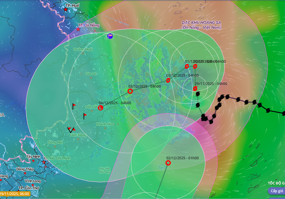 |
Forecasted path and affected area of storm Koto. *Photo: Disaster Monitoring System*
The Japan Meteorological Agency reported the storm's strength at 90 km/h, expecting it to maintain this intensity until reaching the Gia Lai - Dak Lak coastal area before weakening into a tropical depression. The Hong Kong Observatory, however, estimated the storm's current strength at 105 km/h, predicting it will decrease to 65 km/h before approaching the Gia Lai - Dak Lak coast.
Storm Koto originated from a tropical depression east of central Philippines, intensified into a storm, and entered the South China Sea on the evening of 25/11, becoming the 15th storm in the region this year. The year 2025 has seen the highest number of storms and tropical depressions in the past 30 years. Natural disasters, primarily typhoons and floods, have resulted in 409 fatalities, 727 injuries, and economic losses exceeding 85 trillion VND. Meanwhile, another tropical depression is active off the coast of Malaysia. Meteorological agencies forecast this tropical depression will enter the South China Sea today, becoming the 21st cyclone in the region this year.
Gia Chinh