The National Center for Hydro-Meteorological Forecasting reported that at 13h on 4/8, the tropical depression's center was located in the southeastern part of the northern South China Sea. It had maximum wind speeds of 49 km/h, force 6, gusting to force 8, and was moving northwest at 5-10 km/h.
By 1h on 5/8, the tropical depression is forecast to remain in the southeastern northern South China Sea, maintaining its intensity and moving slowly eastward. By 13h on the same day, the system will turn east-southeast at about 10 km/h, heading towards the north of Luzon Island, Philippines, and weakening into a low-pressure area.
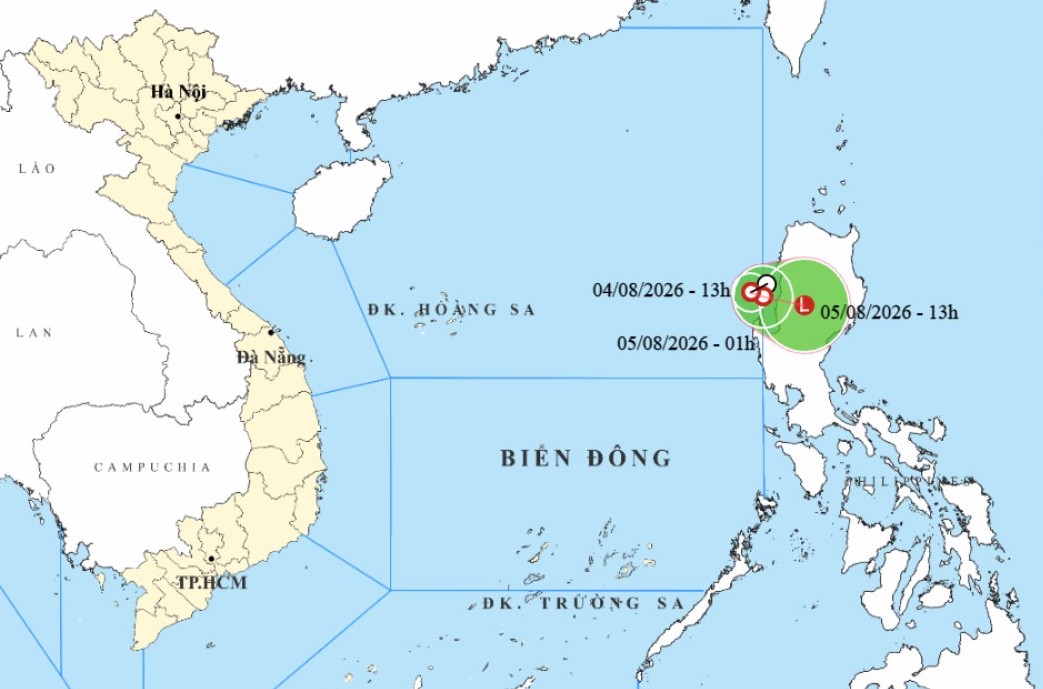 |
Tropical depression forms in the South China Sea. *Photo: NCHMF*. |
On the afternoon and night of 4/8, the southeastern northern South China Sea is expected to experience strong winds of force 6, gusting to force 8, and waves 2-3 m high. The meteorological agency confirmed the tropical depression will not affect Vietnam's coastal areas or mainland.
Vessels operating in the danger zone, specifically between latitudes 16 and 18 and east of longitude 119, are likely to face thunderstorms, whirlwinds, strong winds, and high waves.
Since the beginning of the year, the South China Sea has experienced two storms, Maysak and Noul, in addition to two tropical depressions. Storm Maysak, in early July, caused no human casualties but damaged 96 homes, with roofs blown off. Thirteen boats and rafts were either drifted or sank, and approximately 1,100 ha of aquaculture were affected, leading to total damages of about 20 billion VND.
Meanwhile, Super Typhoon Dolphin is active in the northwestern Pacific. By 4/8, the typhoon maintained maximum winds near its center of about 162 km/h, equivalent to force 14 on Vietnam's typhoon scale, with gusts above force 17. The typhoon is forecast to move towards southeastern China and not enter the South China Sea. However, its wide circulation will intensify the southwest monsoon in the South China Sea.
Gia Chinh