Typhoon Koto, the 15th storm to enter the Bien Dong this year, has weakened into a tropical depression. The National Center for Hydro-Meteorological Forecasting reported that the storm gradually lost energy after six days of forming from a tropical low-pressure area east of the Philippines.
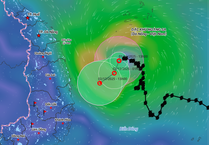
As of 1 PM today, the tropical depression was located in the northwestern part of the central Bien Dong. It had maximum wind speeds of 61 km/h, corresponding to level 7, with gusts up to level 9, and showed minimal movement.
The forecast indicates that by 1 AM tomorrow, the tropical depression will be approximately 200 km east of the coast of Gia Lai and Dak Lak provinces. Its wind speeds are expected to drop to level 6, with gusts up to level 8. It will move south-southwest at 5 km/h before further weakening into a low-pressure area.
Dangerous sea conditions persist in the northwestern part of the central Bien Dong and off the coast of Gia Lai and Dak Lak. Winds will reach level 6-7, with gusts up to level 9, and waves are expected to be two to four meters high. Vessels operating in these hazardous areas face potential risks.
Due to the combined effects of Typhoon Koto's circulation and cold air from the north, the eastern parts of provinces from Quang Ngai to Dak Lak and Khanh Hoa will experience heavy rainfall. From tomorrow night until the end of 3/12, these areas are forecast to receive 70-120 mm of rain, with some places exceeding 180 mm.
The storm has already caused damage and casualties. According to the Department of Dyke Management and Natural Disaster Prevention, strong winds and high waves from Typhoon Koto sank a vessel approximately 300 meters off Binh Thien beach in Khanh Hoa province, resulting in one death and two missing persons. In Lam Dong province, one person died when their coracle was capsized by waves. Additionally, 17 cages and 26 pens for aquaculture were damaged, and 200 meters of coastal embankment in Ham Tien 1 neighborhood suffered erosion.
In response to the storm, the Prime Minister issued an official dispatch. Dak Lak province implemented a sea ban starting at 6 AM on 26/11, while Khanh Hoa and Lam Dong provinces imposed bans at 7 AM on 28/11. Provinces from Da Nang to Dak Lak lowered reservoir water levels to accommodate potential floods, creating a flood control capacity for downstream areas. By 5 AM on 26/11, the total remaining flood reception capacity reached 320.83 million cubic meters.
 |
Typhoon Koto weakens to a tropical depression at sea. Photo: Natural disaster monitoring system
Koto originated as a tropical low-pressure area in the central Philippines on the evening of 25/11. Hours later, it entered the Bien Dong, becoming the 15th storm in the region. This marks a record-breaking season for the number of storms and tropical depressions over the past 30 years.
Two days after entering the Bien Dong, when it was 190 km from Song Tu Tay island, the typhoon reached its peak intensity at level 12, with gusts up to level 15. At that time, Vietnam's meteorological agency presented two possible paths for the storm. The scenario with an 80% probability predicted that when the storm was approximately 500 km off the coast of Gia Lai and Khanh Hoa, it would change direction northward, weaken into a tropical depression, then into a low-pressure area, and drift towards the South Central Coast.
The typhoon indeed followed this predicted scenario, continuously changing direction. Hoang Phuc Lam, Deputy Director of the National Center for Hydro-Meteorological Forecasting, explained that the subtropical high pressure system was the primary factor influencing the storm's path. In recent days, this high-pressure system began to weaken, reducing its steering influence on the storm. Furthermore, as the storm moved westward, it moved further away from the high-pressure system, causing it to shift northward.
Looking ahead, meteorological agencies anticipate the potential for one to two storms or tropical depressions to form in the Bien Dong during December 2025.