The National Center for Hydro-Meteorological Forecasting reported that at 4 a.m. on 25/7, typhoon Noul was located in the northeastern North East Sea, approximately 580 km southeast of Hong Kong (China). It had maximum sustained winds of 117 km/h, reaching level 10-11, with gusts up to level 13, and was moving west-northwest at about 20 km/h.
By 4 a.m. on 26/7, the typhoon is forecast to be in the coastal waters of Guangdong province. Its maximum sustained winds are expected to intensify to 133 km/h, level 12, with gusts up to level 14, maintaining its direction but increasing its speed to 20-25 km/h.
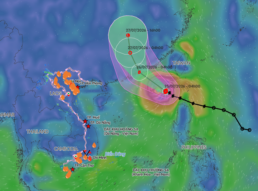 |
Forecast track and impact area of typhoon Noul. *Photo: Disaster Monitoring System*
Following landfall, Noul is projected to turn north-northwest, moving at 15-20 km/h, and gradually weaken into a tropical depression as it moves inland over Guangdong province. By the afternoon of 27/7, it will further dissipate into a low-pressure area over Hunan province, China.
International meteorological agencies offer varying predictions for Noul's peak intensity. The Japan Meteorological Agency forecasts the typhoon could reach 126 km/h before making landfall, while the Hong Kong Observatory suggests its maximum intensity might increase to 140 km/h.
Meteorological agencies confirm that typhoon Noul's primary trajectory is west-northwest, with over an 80% chance of making landfall in Guangdong province. It is unlikely to directly affect Vietnam's mainland.
From 25/7, the northeastern North East Sea will experience strong winds of level 6-7 and waves 4-6 m high. Near the typhoon's eye, winds will intensify to level 10-11, later increasing to level 11-12, with gusts up to level 14, and waves 5-7 m high, leading to very rough seas. Vessels operating in this hazardous zone face potential impacts from thunderstorms, squalls, strong winds, and high waves.
So far this year, the East Sea has recorded one tropical depression and two typhoons: Maysak and Noul. Typhoon Maysak, in early July, caused no human casualties but damaged 96 roofs, swept away or sank 13 boats and rafts, and affected about 1,100 ha of aquaculture. Total estimated damages were approximately 20 billion VND.
This year's typhoon season is expected to see a number of typhoons and tropical depressions in the East Sea similar to or lower than the multi-year average. However, their intensity and trajectory could be unpredictable. The July-September period is considered the peak of the typhoon season, while extreme heavy rains, flash floods, and landslides remain significant risks in Vietnam's Northern Mountains and Central regions.
By Gia Chinh