At 4 a.m., the National Center for Hydro-Meteorological Forecasting reported that Typhoon Wipha had maximum sustained winds of 117 km/h, reaching level 11 and gusting to level 14. It was located in the northern part of the East Sea, 830 km east of Quang Ninh - Hai Phong, and moving west-northwest at 20-25 km/h.
By 4 a.m. on 21/7, the typhoon is expected to strengthen to levels 11-12, with gusts up to level 15, as it approaches the northeastern part of the Leizhou Peninsula (China). After crossing the peninsula, it is predicted to weaken slightly to levels 10-11, with gusts up to level 14, by 4 a.m. on 22/7, when it reaches the waters off Quang Ninh - Ninh Binh.
At a speed of 15 km/h, the typhoon will then move into the waters off Quang Ninh - Hai Phong, further into the North Vietnam Delta, and Thanh Hoa, before weakening into a tropical depression.
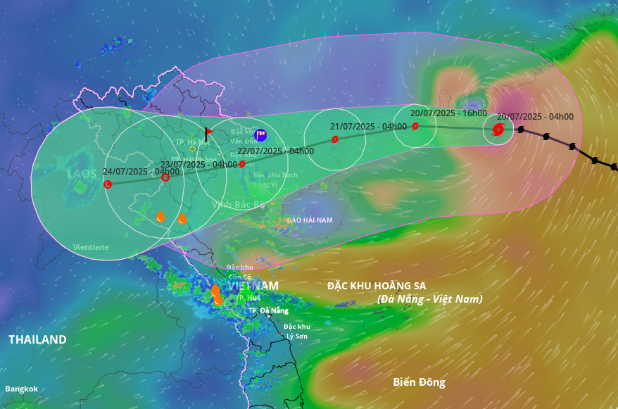 |
Projected path and affected area of Typhoon Wipha, morning of 20/7. Photo: Disaster Monitoring System |
Projected path and affected area of Typhoon Wipha, morning of 20/7. Photo: Disaster Monitoring System
This morning, the Japan Meteorological Agency forecast that the typhoon will cross the Leizhou Peninsula and then veer towards northern Vietnam. As it approaches the northern mainland, the typhoon is expected to maintain its intensity at 108 km/h, rather than weakening as previously predicted. Similarly, the Hong Kong Observatory estimates that the typhoon will maintain winds of around 120 km/h when off the coast of Quang Ninh - Hai Phong.
Due to the typhoon's influence, winds in the northern part of the East Sea will gradually increase from levels 8 to 12, with gusts up to level 15, and waves will reach 5-7 m. Starting tonight, in the northern Gulf of Tonkin (including Bach Long Vi, Co To, and Cat Hai special economic zones), winds will gradually increase from level 6 to 11, with gusts up to level 14, and waves will reach 2-4 m, and 3-5 m near the typhoon's center.
From 21/7, the southern Gulf of Tonkin will experience increasing winds from levels 6 to 9, with gusts up to level 11, and waves of 2-4 m. Vessels operating in these dangerous areas are all likely to be affected.
The coastal areas of Hai Phong - Quang Ninh are forecast to experience storm surges of 0.5-0.8 m, which, combined with high tides, will create a total water level of 4.1 m (at Hon Dau, Hai Phong City) to 5 m (at Bai Chay, Quang Ninh Province), causing flooding in low-lying coastal areas and river mouths during midday and afternoon on 22/7.
From the evening and night of 21/7, inland areas from Quang Ninh to Thanh Hoa will see winds gradually increasing to levels 7-9, gusting to levels 10-11; further inland, winds will reach levels 6-7, gusting to levels 8-9; and near the typhoon's center, winds will reach levels 10-11, gusting to level 14.
From 21-23/7, northern and north-central Vietnam are likely to experience heavy rain, with widespread rainfall totals of 100-200 mm, and over 300 mm in some areas. The northeast, North Vietnam Delta, Thanh Hoa, and Nghe An will see 200-350 mm of rain, and over 600 mm in some areas. Meteorological agencies are warning of the risk of heavy downpours exceeding 150 mm/3h.
Gia Chinh