The National Center for Hydro-Meteorological Forecasting (NCHMF) reported that by 7 am tomorrow, the tropical depression will be in the southwestern part of the southern East Sea, with winds at level 7, gusting to level 9, and moving east-northeast at 15 km/h.
By 7 am on 1/12, the tropical depression is expected to be in the northeastern part of the southern East Sea, with wind speeds decreasing to level 6, gusting to level 8.
The Japan Meteorological Agency (JMA) indicated the tropical depression currently has winds of 54 km/h and is forecast to strengthen into a storm within the coming hours. The US Naval Observatory (USNO) shares a similar assessment, expecting it to intensify into a storm.
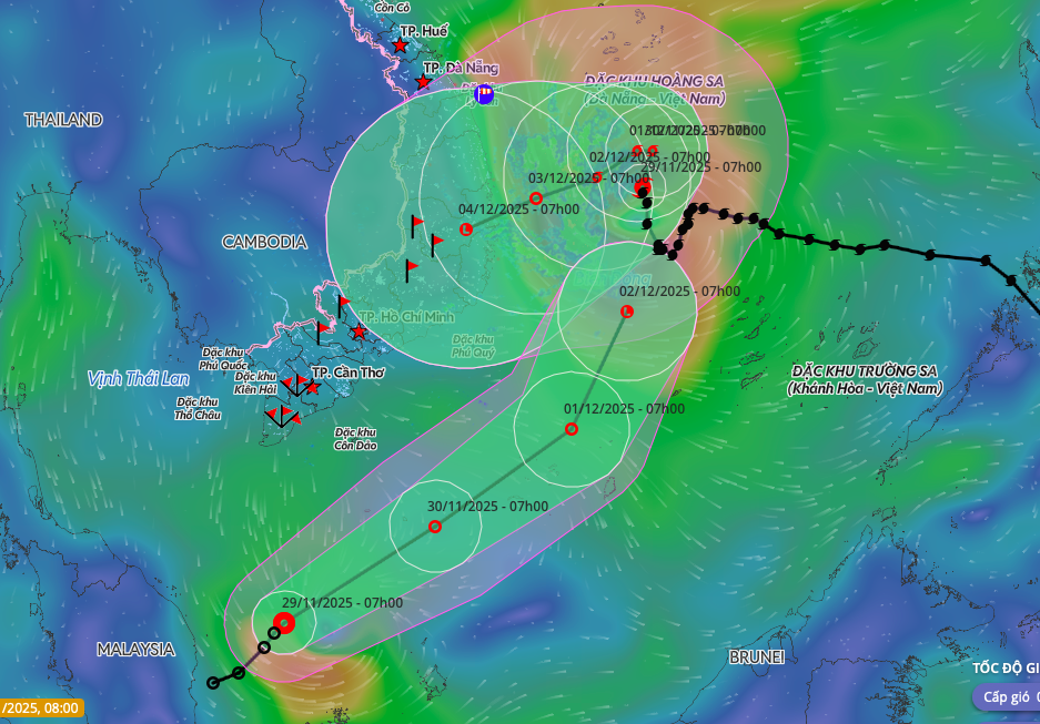 |
Two tropical cyclones appearing simultaneously in the East Sea. Photo: Disaster Monitoring System
According to Mai Van Khiem, Director of the National Center for Hydro-Meteorological Forecasting, the tropical depression originated from the remnants of Typhoon Senyar, moving from the Indian Ocean, through Malaysia, and into the northwestern Pacific Ocean. This trajectory, where a depression forms near the equator and shifts eastward, is extremely rare, "perhaps unprecedented", he stated, citing meteorological records from 1951 to the present, which show most low-latitude depressions moving westward.
Khiem anticipates that within the next 24 hours, the tropical depression will weaken and dissipate over the eastern part of the southern East Sea. It is expected to cause strong winds of levels 6-7, gusting to level 9, and sea waves 2,5-4 m high, without affecting the Southern region mainland.
Concurrently, Typhoon Koto is located approximately 320 km northwest of Song Tu Tay island, with intensity at levels 9-10, gusting to level 13. Over the next 24 hours, the typhoon is forecast to continue moving north. From 1/12, it will change direction to the west, then a day later shift west-southwest, before moving distinctly southward and gradually weakening.
Meteorological agencies predict that Typhoon Koto will likely weaken into a tropical depression, or even a low-pressure area, before reaching the South Central Coast. The storm is expected to bring strong winds of levels 6-10 and sea waves 4-6 m high to the sea area from Gia Lai to Khanh Hoa.
Inland areas from Hue to Khanh Hoa are forecast to experience rainfall totaling 70-150 mm from 2-3/12.
On the afternoon of 28/11, the National Steering Committee for Civil Defense issued an official dispatch urging provinces and cities from Da Nang to An Giang to closely monitor developments, notify vessels to avoid dangerous areas, and prepare rescue forces as needed.
To date, the East Sea has recorded 15 storms and 6 tropical depressions, the highest number in 30 years, surpassing 2017. Storms and floods since the beginning of the year have resulted in 409 fatalities and caused over 85.000 ty dong in damages.
Gia Chinh