The National Center for Hydro-Meteorological Forecasting reported that the typhoon has been internationally named Co May. At 7 p.m. today, the typhoon's center was in the northeast of the East Sea, with maximum sustained winds of 74 km/h, category 8, gusting to category 10. It's moving west-southwest at 15 km/h.
The tropical depression intensified into a typhoon earlier than predicted by Vietnamese meteorological agencies. This is because the system was located on the intertropical convergence zone, with ample moisture and warm sea surface temperatures, providing favorable conditions for strengthening.
By 7 a.m. tomorrow, the typhoon is forecast to reach category 8-9, with gusts up to category 11, over the northeastern area of the East Sea. It will move south-southwest at 10-15 km/h and may intensify further. By 7 p.m., it's expected to reach category 9, gusting to category 11, over the northeastern part of the East Sea, then shift to a south-southeast direction, slowing to 5-10 km/h.
In the following hours, the typhoon is projected to move towards the northern part of Luzon island in the Philippines and weaken into a tropical depression.
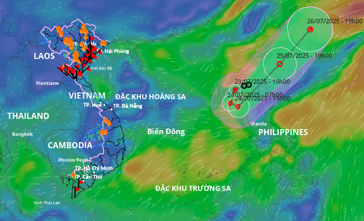 |
Projected path of Typhoon Co May on the evening of 23/7. Image: Disaster Monitoring System |
Projected path of Typhoon Co May on the evening of 23/7. Image: Disaster Monitoring System
The Japan Meteorological Agency predicts the typhoon will not intensify beyond 72 km/h, instead turning back towards the northern part of Luzon island and weakening. The Hong Kong Observatory suggests maximum winds could reach 85 km/h. Both agencies agree that the typhoon won't directly impact Vietnam's mainland.
The Ministry of Agriculture and Rural Development issued an official dispatch this afternoon, requesting coastal provinces from Quang Ninh to Dak Lak closely monitor the tropical depression's development into a typhoon. They are to inform vessels of the danger zone and prepare rescue forces for deployment if needed.
Four typhoons have formed in the East Sea since the beginning of the year, two of which affected Vietnam. The most recent, Typhoon Wipha, made landfall between Hung Yen and Ninh Binh yesterday afternoon, with maximum sustained winds of category 10, gusting to category 14, recorded at the Tien Yen station (Quang Ninh).
Despite its moderate intensity, the typhoon brought heavy rain, particularly to Thanh Hoa and Nghe An provinces. Rainfall totals over three days, from 7 p.m. on 20/7 to 7 a.m. today, reached 487 mm in Sam Son (Thanh Hoa), 390 mm in Muong Long (Nghe An), 338 mm in Phu Le (Ninh Binh), and 205 mm in Da Coc (Hung Yen).
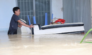
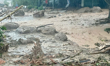
The heavy rainfall led to two deaths in Nghe An due to flash floods and landslides, with five people injured. 687 houses were damaged or lost their roofs. Over 119,000 hectares of rice paddies, primarily in Ninh Binh, were flooded. Many households in the mountainous areas of Nghe An had to evacuate overnight, with floodwaters reaching a meter high in some homes.
Meteorological agencies forecast around seven more typhoons in the East Sea between now and October, three of which are expected to affect the mainland.
Gia Chinh