The National Center for Hydro-Meteorological Forecasting reported that at 4h today, typhoon Koto was in the northwestern part of the central South China Sea. It had maximum sustained winds of 88 km/h, category 9, gusting to category 11, and was moving north-northeast at 3 km/h. The typhoon has maintained category 9 strength since yesterday morning, following an erratic and constantly changing path.
By 4h tomorrow, the typhoon is expected to be in the northwestern part of the central South China Sea, about 340 km east of the eastern coast of Gia Lai - Dak Lak province. It is forecast to maintain category 9 strength, gusting to category 11, and move north at 3 km/h.
Further weakening is anticipated by 4h on 2/12, when the typhoon will be approximately 230 km east of the eastern coast of Gia Lai - Dak Lak provinces. Winds are expected to decrease to category 8, gusting to category 10, and the typhoon will shift west-southwest at 3-5 km/h.
By 4h on 3/12, when about 120 km east of the eastern coast of Gia Lai - Dak Lak provinces, typhoon Koto is expected to weaken into a tropical depression.
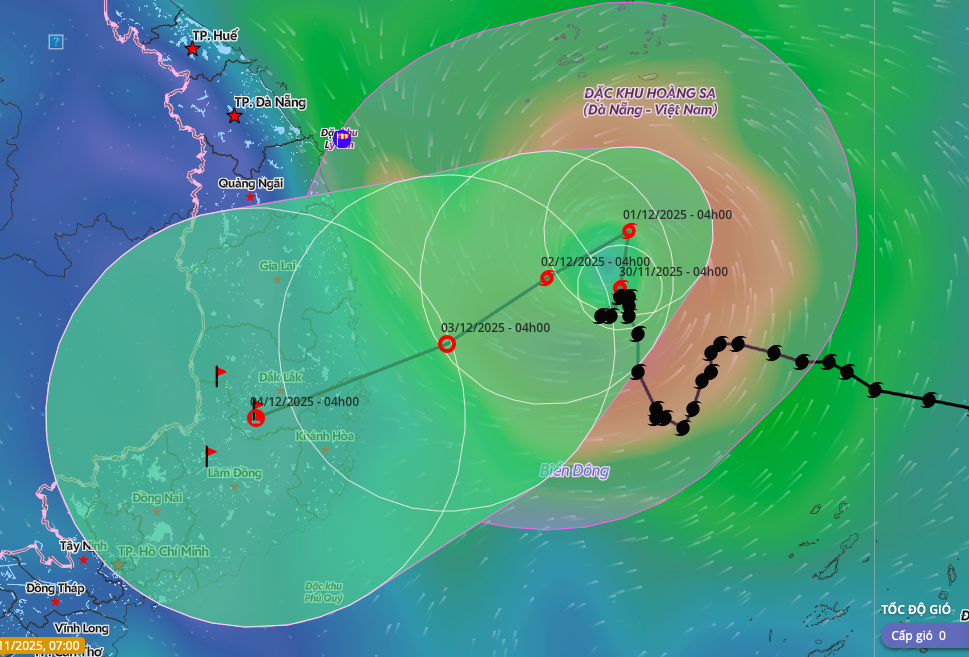 |
Forecast track and impact zone of typhoon Koto. *Photo: Disaster Monitoring System*
Other meteorological agencies also predict Koto's weakening. Japan's meteorological agency reported the typhoon currently has winds of 90 km/h, expected to decrease to 72 km/h tomorrow as it changes direction. The Hong Kong observatory believes the typhoon will weaken into a tropical depression off the coast of Gia Lai - Dak Lak.
Due to the typhoon's influence, the northwestern part of the central South China Sea is experiencing strong winds of category 7-9, gusting to category 11. Sea waves are 3-7 m high. Vessels operating in these dangerous areas are likely to be affected.
Prime Minister Pham Minh Chinh has signed an official dispatch, urging ministries, agencies, and provincial authorities to proactively respond at the highest level. They are to closely monitor developments and act early, with the goal of ensuring public safety and minimizing damage. Ministers and chairpersons of provincial People's Committees will be held accountable to the government for the effectiveness of their response.
The Border Guard Command reported that as of 6h30 today, provinces from Quang Tri to An Giang have informed and guided 66,843 vessels with 335,340 people about the typhoon and tropical depression developments for proactive prevention. Currently, no vessels are in the danger zone. Localities from Da Nang to Dak Lak have lowered reservoir water levels, creating flood control capacity for downstream areas.
Koto originated as a tropical depression east of central Philippines, intensified into a typhoon, and entered the South China Sea on the evening of 25/11, becoming the 15th typhoon in this sea area. So far this year, the South China Sea has recorded 15 typhoons and 6 tropical depressions, marking the highest level in 30 years, surpassing 2017.
Storms and floods since the beginning of the year have caused 409 deaths, injured 727 people, and resulted in economic damage exceeding 85 trillion VND. The number of typhoons and tropical depressions recorded this year marks the highest in 30 years.
Gia Chinh