The National Center for Hydro-Meteorological Forecasting said the typhoon is moving northwest at 20 km/h. By 7 a.m. tomorrow, it is expected to intensify to a category 10-11 storm, with gusts of up to category 13, over the northern part of the South China Sea, about 600 km from the Leizhou Peninsula (China), and will shift its direction to the west-northwest at a speed of 20 km/h.
By 7 a.m. on 21/7, the typhoon will reach category 11-12, with gusts up to category 14, when it is east of the Leizhou Peninsula. It will maintain its speed but shift westward into the Gulf of Tonkin. By 7 a.m. on 22/7, the typhoon will weaken to category 9, with gusts up to category 12, while in the Gulf of Tonkin, before changing direction to the southwest and making landfall.
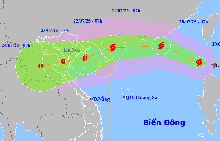 |
Forecast track and affected area of Typhoon Wipha, morning of 19/7. Photo: NCHMF |
Forecast track and affected area of Typhoon Wipha, morning of 19/7. Photo: NCHMF
The Japan Meteorological Agency predicts that the typhoon will reach its peak intensity tonight and tomorrow, with winds of 108 km/h. It will move north of the Leizhou Peninsula and along the coast of China before turning towards Vietnam. The Hong Kong Observatory predicts that the typhoon will reach its maximum intensity with winds of 130 km/h, weakening to 90 km/h when entering the Gulf of Tonkin, before making landfall in the Quang Ninh - Hai Phong area.
Due to the typhoon's influence, winds in the northeastern part of the South China Sea will gradually increase to levels 6-7, reaching levels 8-9 near the typhoon's center, and later increasing to 10-11 with gusts up to 13. Waves will be 4-6 m high. Ships operating in this area are likely to be affected.
During a regular meeting of the Steering Committee for Storm and Flood Prevention on 19/7, the Ministry of Agriculture and Rural Development noted that Typhoon Wipha's track is similar to that of Typhoon Yagi. While it may not be as strong, it is expected to bring heavy rain to northern Vietnam.
With 137 seriously damaged reservoirs and 47 reservoirs currently under construction in the region, and water storage levels at an average of 59-85% of design capacity, the Ministry has requested that units carefully calculate flood discharge plans to ensure the safety of dams and "avoid a repeat of the situation at Thac Ba Hydropower Plant last year."
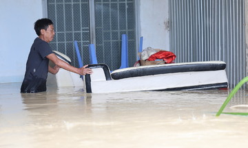
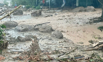
Since the beginning of the year, the South China Sea has experienced three typhoons. Typhoon Danas did not affect the mainland. Typhoon Wutip in June did not make landfall but caused heavy rain from 11/6 to 13/6 in north-central Vietnam. This period of heavy rain and flooding resulted in 11 fatalities in Quang Tri and Hue City, flooded over 3,500 houses, and affected 88,000 hectares of crops. Many traffic routes experienced landslides and flooding; flights from Da Nang were delayed or canceled; and the Miss Vietnam final had to be postponed due to rising floodwaters on the Perfume River.
Gia Chinh