On the afternoon of 28/11, the National Center for Hydro-Meteorological Forecasting announced that a tropical depression was moving from an area near the equator, east of Malaysia, northeastward at approximately 15 km/h. Currently, wind speeds are at level 6-7, gusting to level 9, and it is forecast to enter the East Sea tonight or tomorrow morning. By 19:00 tomorrow, the center of the cyclone is expected to be in the southwestern part of the southern East Sea, with wind speeds increasing to level 7, gusting to level 9.
According to Mai Van Khiem, Director of the National Center for Hydro-Meteorological Forecasting, this cyclone originated from the remnants of Typhoon Senyar, which moved from the Indian Ocean, across Malaysia, to the northwestern Pacific Ocean. Since 1951, agencies have recorded some depressions forming below 5 degrees north latitude; however, most moved westward. A depression originating near the equator and then veering eastward, like the current system, is "very rare, perhaps even unprecedented."
Concurrently, Typhoon Koto is active in the East Sea, located about 200 km northwest of Song Tu Tay island, with wind speeds at level 10, gusting to level 13, and moving slowly at 3-5 km/h toward the west-northwest. The tropical depression does not affect Typhoon Koto's path.
Forecasts indicate that by tomorrow evening, the typhoon will be in the western part of the central East Sea, approximately 305 km from Song Tu Tay, with wind speeds remaining at level 9-10, gusting to level 13. By the evening of 30/11, the typhoon is expected to continue moving north, weakening to level 9, gusting to level 12, and will be about 320 km off the eastern coast of Gia Lai.
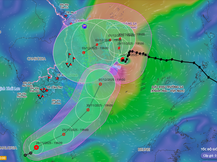 |
Two potential tropical cyclones in the East Sea. Photo: Disaster Monitoring System |
Different meteorological stations offer varying forecasts for Typhoon Koto’s intensity. Japan predicts the typhoon will have winds of 82 km/h, potentially increasing to 90 km/h by 30/11. In contrast, Hong Kong assesses the typhoon's current winds at 105 km/h, expecting them to gradually decrease to about 65 km/h as it approaches land, with a tendency to weaken before reaching the central region.
Regarding the tropical depression near the East Sea, the Japanese station no longer anticipates it strengthening into a typhoon, as previously thought. The system is likely to remain at depression level and weaken over the sea.
According to the domestic meteorological agency’s assessment, the probability of this cyclone directly affecting the Southern region is low. Its circulation will primarily cause strong winds in the southwestern East Sea, including the western area of the Truong Sa archipelago. Sea waves are forecast to be 2,5-4 m high, with winds at level 6-7, gusting to level 8.
On the afternoon of 29/11, the National Steering Committee for Civil Defense issued an urgent dispatch, instructing provinces from Da Nang to An Giang to closely monitor developments, notify vessels to avoid dangerous areas, and prepare rescue forces as needed.
To date, the East Sea has recorded 15 typhoons and five tropical depressions, the highest level in 30 years, comparable to 2017. Floods and storms since the beginning of the year have resulted in 409 fatalities and caused over 85,000 billion VND in damages.
Gia Chinh