The National Center for Hydro-Meteorological Forecasting announced that from 15-16/6, the northern region will receive heavy rainfall, concentrated in the midland and mountainous areas. Rainfall amounts are expected to be 30-50 mm daily, with some locations potentially exceeding 120 mm. Continuous thunderstorms over several days will lead to lower temperatures, meaning the North is unlikely to experience a heatwave next week.
Maximum temperatures in this area are generally forecast to stay below 35 degrees C. Around 20/6, rain is expected to gradually decrease, and temperatures will begin to rise again.
 |
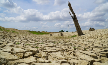
The northern region will see widespread rain next week. Photo: Ngoc Thanh
Accuweather, an American weather service, predicts that Hanoi's temperature tomorrow will drop by 4-5 degrees compared to today, settling between 26-34 degrees C, then further decreasing to 26-30 degrees C. High-altitude areas above 1,500 m, such as Sa Pa (Lao Cai), will see temperatures ranging from 19-23 degrees C next week.
In the Central region, a widespread heatwave will persist from Thanh Hoa to Da Nang on 15/6, extending to the eastern parts of Quang Ngai, Gia Lai, and Dak Lak provinces. Maximum temperatures are forecast to be 35-37 degrees C.
From 16-18/6, the heatwave's scope will narrow, primarily affecting the Central Coast, from southern Quang Tri to the eastern Dak Lak area, with temperatures continuing to range from 35-37 degrees C.
Forecasts indicate that around 19/6, the western hot low-pressure area will redevelop, leading to an increase in the intensity of the heatwave across the Central region.
Meanwhile, the Central Highlands and Southern region will be influenced by a moderate to weak southwest monsoon. The weather will generally be sunny during the day, with showers and thunderstorms appearing in the afternoon and evening. Some localized areas may experience heavy rain, accompanied by risks of whirlwinds, lightning, and strong wind gusts.
By Gia Chinh
>> See detailed 7-day weather forecast.